
Bendigo is a city in Victoria, Australia, located near the geographical centre of the state and approximately 150 kilometres (93 mi) north west of Melbourne, the state capital. As of 2019, Bendigo had an urban population of 100,991, making it Australia's 19th largest city, fourth-largest inland city and the fourth-most populous city in Victoria. It is the administrative centre of the City of Greater Bendigo, which encompasses outlying towns spanning an area of approximately 3,000 km2 and over 111,000 people. Residents of the city are known as "Bendigonians".

Castlemaine is a small city in Victoria, Australia, in the Goldfields region about 120 kilometres northwest by road from Melbourne and about 40 kilometres from the major provincial centre of Bendigo. It is the administrative and economic centre of the Shire of Mount Alexander. The population at the 2016 Census was 6,757. Castlemaine was named by the chief goldfield commissioner, Captain W. Wright, in honour of his Irish uncle, Viscount Castlemaine.

The City of Greater Bendigo is a local government area in Victoria, Australia, located in the central part of the state. It covers an area of 3,000 square kilometres (1,200 sq mi) and, in June 2018, had a population of 116,045. It includes the city of Bendigo and the towns of Axedale, Elmore, Heathcote, Marong, Raywood and Strathfieldsaye. It was formed in 1994 from the amalgamation of the former City of Bendigo with the Borough of Eaglehawk, Shire of Strathfieldsaye, Shire of Huntly, Rural City of Marong and parts of the Shire of McIvor. It is the state’s third largest economy base and is considered a service and infrastructure centre for north central Victoria. The city is surrounded by 40,000 hectares of regional, state and national parkland.

The Shire of Macedon Ranges is a region in Central Victoria, Australia, best known for its expansive native forests, iconic geographical attraction Hanging Rock, and thriving artisan food and wine industries. The region covers an area of 1,748 square kilometres (675 sq mi). It is located in between the cities of Bendigo and Melbourne. In June 2018 the shire had a population of 49,388. It includes the towns of Gisborne, Kyneton, Lancefield, Macedon, Malmsbury, Mount Macedon, New Gisborne, Riddells Creek, Romsey and Woodend.
Olinda is a town in the Victorian Dandenongs, with a population of 1,738 as of the 2016 census. Located 36 km east of Melbourne, and within the local government area of the Shire of Yarra Ranges. It is a popular weekend destination for tourists, with a variety of restaurants and cafes. The town is home to the National Rhododendron Garden and R.J. Hamer Arboretum.

Deer Park is a suburb of Melbourne, Victoria, Australia, 17 km west of Melbourne's Central Business District, located within the City of Brimbank local government area. Deer Park recorded a population of 18,126 at the 2016 Census.

Riddells Creek railway station is located on the Bendigo line in Victoria, Australia. It serves the town of Riddells Creek.

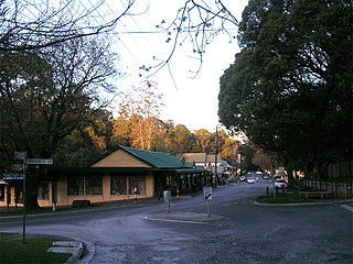
Riddells Creek is a town in Victoria, Australia, located in the Shire of Macedon Ranges. It is located in between the cities of Bendigo and Melbourne. Riddells Creek is also the name of the main watercourse which flows through the township, and which is a tributary of Jacksons Creek to the south. The town is served by Riddells Creek railway station on the Bendigo line. At the 2016 census, Riddells Creek had a population of 3167.

Strathfieldsaye is a suburb of the Greater City of Bendigo in Victoria, Australia. It is located 9 kilometres (5.6 mi) south-east of the Bendigo CBD.

Golden Square is a suburb of Bendigo in Victoria, Australia. Its local government area is the City of Greater Bendigo. At the 2016 Census, Golden Square had a population of 8,820.

The Bendigo Advertiser is the daily (Monday–Saturday) newspaper for Bendigo, Victoria and its surrounding region. The Bendigo Advertiser is published by Australian Community Media with a circulation area of over 140,000 residents.

Lancefield is a town in the Shire of Macedon Ranges local government area in Victoria, Australia 69 kilometres (43 mi) north of the state capital, Melbourne and had a population of 2,357 at the 2011 census.

Serpentine is a town in north west Victoria, Australia. Located on the Loddon Valley Highway, the town is 201 kilometres north west of the state capital, Melbourne and 51 kilometres north west of the regional centre, Bendigo. Serpentine is in the Shire of Loddon local government area and, including the surrounding state suburb, had a population of 192 at the 2016 census.

Taradale is a small town in Victoria, Australia. It is located beside the Calder Highway between Melbourne and Bendigo. Its local government area is the Shire of Mount Alexander. At the 2016 census, Taradale had a population of 448.
The Shire of Strathfieldsaye was a local government area immediately to the east and southeast of the regional city of Bendigo, Victoria, Australia, and included the eastern suburbs of Bendigo's metropolitan area. The shire covered an area of 601.34 square kilometres (232.2 sq mi), and existed from 1861 until 1994.
The O'Keefe Rail Trail is a 50-kilometre (31 mi) rail trail connecting Bendigo with Heathcote. The sandy gravel trail runs along a former branch line on the Melbourne-Sydney rail line. It previously ran 17 km (11 mi) from Bendigo to Axedale but works completed in 2015 extended the route to Heathcote

During the Australian gold rushes, significant numbers of workers relocated to areas in which gold had been discovered. Gold was found several times in Australia before 1851, but there were only gold rushes from 1851 onwards, mainly because the colonial government of New South Wales had previously suppressed news of gold finds which it believed would reduce the workforce and destabilise the economy.
Nerrina is a suburb of Ballarat, Victoria, Australia on the north-eastern rural-urban fringe of the city, 4 kilometres (2.5 mi) east of the Central Business District. The population at the 2016 census was 962.

Bendigo is a settlement and historic area in Central Otago, in the southern South Island of New Zealand. It is located some 20 kilometres to the north of Cromwell, to the east of the head of Lake Dunstan, on the banks of the Bendigo Creek, a small tributary of the Clutha River.
The Heathcote Railway line was a railway line linking Bendigo and Heathcote Junction. It was opened in 1888, and, by 1890 it was fully operational. It was partially closed in 1958 and fully closed in 1968.

