Jackass Flat, Victoria

Last updated
Jackass Flat
Bendigo,  Victoria
Australia Victoria Bendigo City location map.svg
Red pog.svg
Jackass Flat
Coordinates 36°43′0″S144°17′0″E / 36.71667°S 144.28333°E / -36.71667; 144.28333 Coordinates: 36°43′0″S144°17′0″E / 36.71667°S 144.28333°E / -36.71667; 144.28333
Population1,141 (2016 census) [1]
Postcode(s) 3551
Location6.5 km (4 mi) N of Bendigo
LGA(s) City of Greater Bendigo
State electorate(s) Bendigo East
Federal Division(s) Bendigo

Jackass Flat is a suburb of the city of Bendigo in central Victoria, Australia. Jackass Flat is in the City of Greater Bendigo, 6.5 kilometres (4.0 mi) north of the Bendigo central business district.

Bendigo City in Victoria, Australia

Bendigo is a city in Victoria, Australia, located near the geographical centre of the state and approximately 150 kilometres (93 mi) north west of the state capital, Melbourne. As of June 2016, Bendigo had an urban population of 95,587, making it the fourth largest inland city in Australia and fourth most populous city in the state. It is the administrative centre for the City of Greater Bendigo which encompasses both the urban area and outlying towns spanning an area of approximately 3,000 square kilometres and over 111,000 people.

City of Greater Bendigo Local government area in Victoria, Australia

The City of Greater Bendigo is a local government area in Victoria, Australia, located in the central part of the state. It covers an area of 3,048 square kilometres (1,177 sq mi) and, at the 2016 Census, had a population of 110,477. It includes the city of Bendigo and the towns of Axedale, Elmore, Heathcote, Marong, Raywood and Strathfieldsaye. It was formed in 1994 from the amalgamation of the former City of Bendigo with the Borough of Eaglehawk, Shire of Strathfieldsaye, Shire of Huntly, Rural City of Marong and parts of the Shire of McIvor.

Contents

History

At the 2006 census, Jackass Flat had a population of 224. [2] At the 2016 census, Jackass Flat had a population of 1,141. [3]

Ecology

Jackass Flat Nature Conservation Reserve, a 73.4 hectares (181 acres) reserve was established in 1980. [4] It contains the rare Star-hair ( Astrotricha linearis ) and Shrub Violet ( Hybanthus floribundus ). [5]

Jackass Flat Nature Conservation Reserve Protected area in Victoria, Australia

Jackass Flat Nature Conservation Reserve is a 73.4 hectares reserve, located in Jackass Flat, a northern suburb of Bendigo in Victoria, Australia. The reserve was established in 1980 and is managed by Parks Victoria.

<i>Astrotricha linearis</i> species of plant

Astrotricha linearis, commonly known as known as the narrow-leaf star-hair, is a plant species in the family Araliaceae. The species is endemic to south-east Australia. Plants grow to 1.5 metres high and have linear leaves that are 20 to 65 mm long and 1 to 1.5 mm wide. Flowers appear between October and December in the species native range.

Related Research Articles

Local government areas of the Northern Territory Wikimedia list article

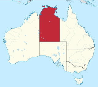
The Northern Territory is a federal Australian territory in the central and central northern regions of Australia. It is the third largest Australian federal division with an area of 1,349,129 square kilometres (520,902 sq mi) but the least populous with 228,833 inhabitants as at the 2016 Census. The Northern Territory is divided administratively into 17 Local government areas (LGAs) generally known as Councils who are responsible for providing local government services.

Kurunjang Suburb of Melbourne, Victoria, Australia

Kurunjang is a suburb of Melbourne, Victoria, Australia, 40 km west of Melbourne's Central Business District, located within the City of Melton local government area. Kurunjang recorded a population of 10,070 at the 2016 Census.

Waitchie, Victoria Town in Victoria, Australia

Waitchie is a locality in Victoria, Australia, located approximately 44 km from Swan Hill, Victoria. At the 2006 census, Waitchie had a population of 118, decreasing to 48 at the 2016 census.

Welshpool, Victoria Town in Victoria, Australia

Welshpool is a town in the South Gippsland region of Victoria, Australia. At the 2016 census, Welshpool had a population of 331.

Maiden Gully, Victoria Suburb of Bendigo, Victoria, Australia

Maiden Gully is a suburb of the regional city of Bendigo in central Victoria, Australia, located 7 kilometres (4.3 mi) west of the central business district along Calder Highway. At the 2016 census, Maiden Gully had a population of 4,992.

Epsom, Victoria Suburb of Bendigo, Victoria, Australia

Epsom is a suburb of the city of Bendigo in central Victoria, Australia. Epsom is in the City of Greater Bendigo, 7 kilometres (4.3 mi) north of the Bendigo central business district. At the 2016 census, Epsom had a population of 4,325.

Nerrina, Victoria Suburb of Ballarat, Victoria, Australia

Nerrina is a suburb of Ballarat, Victoria, Australia on the north-eastern rural-urban fringe of the city, 4 kilometres (2.5 mi) east of the Central Business District. The population at the 2016 census was 962.

Longlea, Victoria Suburb of Bendigo, Victoria, Australia

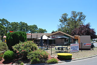
Longlea is a suburb of the city of Bendigo in central Victoria, Australia. Longlea is in the City of Greater Bendigo, 14 kilometres (8.7 mi) East of the Bendigo central business district and approximately 150 kilometres (93 mi) North-West from the Victorian Capital of Melbourne.

Bessiebelle Town in Victoria, Australia

Bessiebelle is a locality in western Victoria, Australia. The locality is in the Shire of Moyne local government area, in what is commonly known as the Western District. Besiebelle is in the County of Normanby cadastral division, approximately 311 kilometres (193 mi) west of the state capital, Melbourne, on the Eumeralla River adjacent to the Mount Eccles National Park.

North Bendigo, Victoria Suburb of Bendigo, Victoria, Australia

North Bendigo is a suburb of the city of Bendigo in central Victoria, Australia. North Bendigo is in the City of Greater Bendigo, 2.4 kilometres (1.5 mi) north of the Bendigo central business district. At the 2011 census, North Bendigo had a population of 3,953.

Huntly, Victoria Town in Victoria, Australia

Huntly is a town in northern Bendigo, Victoria, Australia in the City of Greater Bendigo local government area, 169 kilometres north of the state capital, Melbourne. At the 2016 census, Huntly had a population of 2,379.

Ravenswood, Victoria Town in Victoria, Australia

Ravenswood is a locality in north central Victoria, Australia. The locality is in the City of Greater Bendigo local government area, 136 kilometres (85 mi) north of the state capital, Melbourne.

Knowsley, Victoria Town in Victoria, Australia

Knowsley is a locality in north central Victoria, Australia. The locality is in the City of Greater Bendigo local government area, 134 kilometres (83 mi) north of the state capital, Melbourne.

East Bendigo Suburb of Bendigo, Victoria, Australia

East Bendigo is an inner suburb of the regional city of Bendigo in north central Victoria, Australia, 2 kilometres (1.2 mi) north east of the Bendigo city centre.

Spring Gully, Victoria Suburb of Bendigo, Victoria, Australia

Spring Gully is a suburb of the regional city of Bendigo in north central Victoria, Australia, 5 kilometres (3.1 mi) south of the Bendigo city centre.

Strathdale Suburb of Bendigo, Victoria, Australia

Strathdale is a suburb of the regional city of Bendigo in north central Victoria, Australia, 3 kilometres (1.9 mi) east of the Bendigo city centre.

Ironbark, Victoria Suburb of Bendigo, Victoria, Australia

Ironbark is a suburb of the regional city of Bendigo in north central Victoria, Australia, 2 kilometres (1.2 mi) north west of the Bendigo city centre.

Junortoun, Victoria Suburb of Bendigo, Victoria, Australia

Junortoun is a suburb of Bendigo, Victoria, Australia. The suburb is located 6 kilometres (3.7 mi) east of the Bendigo city centre along the McIvor Highway. At the 2016 census, Junortoun had a population of approximately 3,200.

References

  1. Australian Bureau of Statistics (27 June 2017). "Jackass Flat (State Suburb)". 2016 Census QuickStats. Retrieved 16 March 2018. Blue pencil.svg
  2. Australian Bureau of Statistics (25 October 2007). "Jackass Flat (State Suburb)". 2006 Census QuickStats. Retrieved 20 April 2012.
  3. Australian Bureau of Statistics (27 June 2017). "Jackass Flat". 2016 Census QuickStats. Retrieved 3 August 2017. Blue pencil.svg
  4. "Jackass Flat N.C.R". Parks Victoria. Retrieved 29 October 2014.
  5. "Experience Bendigo Outdoors - City Map" (PDF). Bendigo Tourism. Retrieved 29 October 2014.