
Kotagiri is a hill station and a taluk in the Nilgiris district of the Indian state, Tamil Nadu. The Nilgiri hills have been the traditional home of the "Kota" tribes. The name 'Kota-giri' itself means 'mountains of the kotas'. Kotagiri was known in the past as 'Kota-keri' or 'Kota-gherry', the 'street of Kotas'. The town has developed around numerous knolls and valleys. It is one of the largest hill stations in the Nilgiri Mountains. Located at an average elevation of 1,950 m (6,400 ft), Kotagiri is quietly tucked away in the Nilgiris and used to be one of the summer resorts of Madras Presidency. The town was discovered in the year 1819 by John Sullivan when he came to a village called Dhimbatty to the north of Kotagiri. Kotagiri enjoys the third coldest climate next to Ooty and Kodaikanal in South India.

Dindigul is a city in the Indian state of Tamil Nadu. It is the administrative headquarters of the Dindigul district.Dindigul City is Located in the Southwest Region of Tamil Nadu. Dindigul is an ancient settlement region and has been ruled at different times by the Cheras, Early Pandyas, Cholas, Pallava dynasty, later Pandyas, Madurai Sultanate, Vijayanagara Empire, Madurai Nayak Dynasty, Chanda Sahib, and British. It is the 11th-largest urban agglomeration in the state. Dindigul has a number of historical monuments, the Dindigul Fort being the most prominent.Dindigul is located 420 km (260 mi) southwest from the state capital, Chennai, 100 km (62 mi) away from Tiruchirappalli,66 km (41 mi) away from Madurai and 72 km (45 mi) away from Karur. The city is known for its Famous Locks and its Authentic Thalappakatti Biryani.

Madurai district is one of the 38 districts of the state of Tamil Nadu in southeastern India. The city of Madurai serves as the district headquarters. It houses the famous Sri Meenakshi Sundareshwarar temple and is situated on the banks of the river Vaigai. Thiruparankundram is one of the major tourist place in the district. As of 2011, the district had a population of 3,038,252 with a sex-ratio of 990 females for every 1,000 males. Aside from the city of Madurai, the larger towns are Melur, Vadipatti, Thirumangalam, Thirupparankundram, Peraiyur, and Usilampatti.
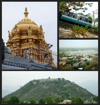
Palani or Pazhani or "Pallhani" is a town in Dindigul district of Tamil Nadu state in India. It is located about 54 kilometres (34 mi) west of Dindigul, 106 kilometres (66 mi) south-east of Coimbatore, 122 kilometres (76 mi) north-west of Madurai, 67 kilometres (42 mi) from Kodaikanal. The Palani Murugan Temple or Arulmigu Dhandayuthapani Swamy Temple, dedicated to Murugan is situated on a hill overlooking the town. The temple is visited by more than 7 million pilgrims each year. As of 2011, the town had a population of 70,467 and the Taluk had a population of 292,301 which makes it the second largest town in the district after Dindigul.

Dindigul District is one of the 38 districts in the state of Tamil Nadu in India. Dindigul District is the largest district in Tamil Nadu by area. The district was carved out of Madurai District in 1985. It has an area of 6266.64 km2 and comprises 3 revenue divisions, 10 taluks, and 14 panchayat unions. The district is located in Southwest of Tamil Nadu. The district is bound by Madurai district in the south,Tiruppur district in the northwest, Karur district in the north, Tiruchirappalli district in the northeast, Theni district in the Southwest and Idukki district of Kerala to the west. As of 2011, the district had a population of 2,159,775 with a sex-ratio of 998 females for every 1,000 males.
Alapakkam is a census town in Chengalpattu district in the state of Tamil Nadu, India. The Alapakkam Census Town has population of 9,404 of which 4,702 are males while 4,702 are females as per report released by Census India 2011.
Kariapatti is a town Panchayat city in district of Virudhunagar district, Tamil Nadu. The Kariapatti Town Panchayat has population of 18,984 of which 9,439 are males while 9,545 are females as per report released by Census India 2011. The Kariapatti city is divided into 15 wards for which elections are held every 5 years.
Kilpennathur is a Panchayat Town in Tiruvanamalai district in the Indian state of Tamil Nadu. Kilpennathur is one of the taluks of Tiruvannamalai district and an assembly constituency of Tamil Nadu. The MLA of Kilpennathur assembly constituency is DMK party Mr. K. Pichandi. Vettavalam is the most populous town panchayat in this taluk. Kilpennathur is located a 12.25 degrees latitude and 79.224 degrees longitude. Nearest towns are Avalurpet, Vettavalam, Gingee and Tiruvannamalai, and Chennai is about 177 km away.
Komaralingam is a town located in the Tiruppur district of Tamil Nadu, India. It is located at a distance of 8 km from Madathukulam, 16 km from Udumalaipettai, 22 km from Palani, 85 km from Coimbatore and 79 km from Tiruppur.
Madathukulam is Border to Dindigul District in Tirupur district in the Indian state of Tamil Nadu.

Muthur is a panchayat town in Vellakovil block which comes under Kangeyam taluk in Tirupur district, Tamil Nadu, India.
Neikkarapatti is a panchayat town in Dindigul district in the Indian state of Tamil Nadu.
Sendarapatti, also known as Senthalai, is a panchayat town in Salem district in the Indian state of Tamil Nadu.

Thenthiruperai is a panchayat town in Thoothukudi district in the Indian state of Tamil Nadu, 11 km from Tiruvaikuntam and 30 km from Thoothukudi. The village hosts one of the nine Nava Tirupathi temples. It also hosts one of the Navakailasams, Then Thiruperai Sri Kailasanathar Temple, the seventh in the series.
Thevur is a Town Panchayat city in Salem district, Tamil Nadu.
Vedasanthoor is a panchayat town in Dindigul district Located at Indian state of Tamil Nadu. Vedasanthoor town is 21 km (13 mi) from Dindigul city, 25 km (16 mi) from Oddanchatram town, and 82 km (51 mi) from Madurai.
Vettavalam is a first grade panchayat town in Tiruvanamalai district in the Indian state of Tamil Nadu.
Ottapidaram is a small town in Thoothukudi district and headquarters of Ottapidaram taluk.
Andipatti taluk is a taluk of Theni district of the Indian state of Tamil Nadu. The headquarters of the taluk is the town of Andipatti.
Thandikudi is a Panchayat in Kodaikanal Circle of Dindigul District in the Indian state of Tamil Nadu. 35 km from Kodaikanal at an altitude of about 3705 feet above sea level in the foothills of the Western Ghats and Palani Hills. Vathalakundu is a forested area.
