
Namakkal is a special grade municipality and the headquarters of Namakkal district in the Indian state of Tamil Nadu. It is the first ISO 14001-2004 certified municipality in Asia for environmental management, specifically the provision and maintenance of water supply, solid waste and sewage management, town planning, lighting and other social services. Namakkal is known as the Egg City due to its large egg production and Transport city.

Karur is a city in the Indian state of Tamil Nadu. Karur is the administrative headquarters of Karur district. It is located on the banks of River Amaravathi, Kaveri and Noyyal. Karur is well known for the export of Home Textile products to USA, UK, Australia, Europe and many more countries. It is situated at about 395 kilometers southwest of the state capital Chennai, 75 km from Tiruchirappalli, 120 km away from Coimbatore, 295 km away from Bengaluru and 300 km away from Kochi.

Rajapalayam is a town in the Indian state of Tamil Nadu. It is the largest municipality in the Virudhunagar district. Rajapalayam is located on the Madurai to Quilon National Highway at a distance of 562 km south of the state capital Chennai. The economy is primarily industrial with several mills for spinning and weaving. The town is known for its mango and the Rajapalayam breed of dogs.

Dindigul, also spelt Thindukkal, is a city in the Indian state of Tamil Nadu. It is the administrative headquarters of the Dindigul district. Dindigul is located 420 km (260 mi) southwest from the state capital, Chennai, 100 km (62 mi) away from Tiruchirappalli, 66 km (41 mi) away from Madurai and 72 km away from the Tex City of Karur. The city is known for its locks and biryani. Parts of Dindigul Districts like Palani, Oddanchatram, Vedasandur, Nilakottai, Kodaikanal, Natham, Athoor.
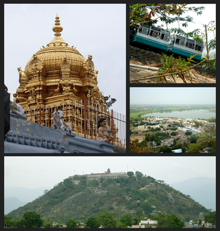
Palani (Tamil:[paɻani] or Palnias in British records, is a town and a taluk headquarters in Dindigul district of the western part of Tamil Nadu state in India. It is located about 106 kilometres south-east of Coimbatore and 122 kilometres north-west of Madurai, 67 kilometres from Kodaikanal. The Palani Murugan Temple or Arulmigu Dhandayuthapani Swamy Temple, dedicated to Murugan is situated on a hill overlooking the town. The temple is visited by more than 7 million pilgrims each year. As of 2011, the town had a population of 292301 which makes it the second largest town in the district after Dindigul.

Dindigul District is one of the 38 districts in the state of Tamil Nadu in India. Dindigul District is the second largest district in Tamil Nadu by area after Thiruvannamalai District. The district was carved out of Madurai District in 1985. It has an area of 6266.64 km2 and comprises 3 revenue divisions, 10 taluks, and 14 panchayat unions. The district is bound by Tiruppur district in the northwest, Karur district in the north, Tiruchirappalli district in the northeast, Madurai and Theni districts in the south, and Idukki district of Kerala to the west. As of 2011, the district had a population of 2,159,775 with a sex-ratio of 998 females for every 1,000 males.

Aravakurichi is a panchayat town and a Taluk headquarters in Karur district in the state of Tamil Nadu, India. Aravakurichi is well known in Tamil Nadu as a major market for Moringa oleifera vegetable. Aravakurichi is the headquarters of Aravakurichi taluk which consists of 40 revenue Villages.

Batlagundu is a town in Nilakottai block in Dindigul district in the Madurai Region state of Tamil Nadu, India. The name Vetrilaikkundru later transformed and changed to Vathalagundu. The town is the major gateway to Kodaikanal. Subramaniya Siva was a writer, Indian Freedom Fighter, and activist born in Batlagundu. Batlagundu is the fifth-largest town in the Dindigul district. The town is located in such a way connecting three main districts of South Tamil Nadu. Batlagundu has most of the voters in Nilakottai Constituency.

Oddanchatram is a town in Dindigul district in the Indian state of Tamil Nadu. Oddanchatram is a region in the southwest of Tamil Nadu. The Town was carved out of Madurai District in 1985. Oddanchatram is also famous for vegetable and cattle market. As of 2011, the town had a population of 30,064. It is known as vegetable city of Tamil Nadu. Oddanchatram vegetable market is the largest supplying of vegetables in Tamilnadu and Kerala. Agriculture is the major economic support for the town.
Kaveripattinam is a town in Krishnagiri district in the northern part of Tamil Nadu.It is a revenue block in the Krishnagiri district of Tamil Nadu, India. It has a total of 36 panchayat villages.

Lalgudi is a town in Tiruchirapalli district in the Indian state of Tamil Nadu. The town of Lalgudi heads the Lalgudi taluk, Lalgudi division, Lalgudi Educational District, Lalgudi DSP and Lalgudi Constituency.
Mallur is a village or town council (panchayat) in the Salem district, which is located in the Indian state of Tamil Nadu.

Manapparai is a town and a municipality in Tiruchirappalli district in the Indian state of Tamil Nadu. Manapparai Town is Located at 38 km Away From Trichy. Manapparai is the headquarters of the Manapparai Taluk. Manapparai is famous for murukku and cattle market. As of 2011, the town had a population of 40,510.
Vedasanthoor is a panchayat town in Dindigul district Located at Indian state of Tamil Nadu. Vedasanthoor town is 21 km (13 mi) from Dindigul city, 25 km (16 mi) from Oddanchatram town, and 82 km (51 mi) from Madurai.
Paramathi Velur, a town in Paramathi-Velur taluk, Namakkal District, Tamil Nadu, India is situated just off the Srinagar - Kanyakumari National Highway 44 (India). This town is also called as Paramathi Velur, with STD Code 04268 & Postal code 638182.

Pallapatti is one of three municipalities of Karur district in Tamil Nadu, India. The history of Pallapatti dates back 600 years. It is accessible from the NH 44 connecting Dindigul and Karur and is located 46 km (29 mi) from Dindigul and 35 km (22 mi) from Karur, which can be reached through Aravakurichi town. Pallapatti is a Muslim-majority town that emphasizes passing traditional and cultural values across generations. There are several mosques, a church and a temple. The Nankanji River flows through Pallapatti.

Sengottai is a town in the Tenkasi district, of Tamil Nadu, India. It is the gateway to southern Tamil Nadu and Kerala. Spread over an area of 2.68 km2 with a population of over 26,823, the economy of the town and Sengottai Taluk revolves around the cultivation of rice,coconut,Mango,clove and pepper. Sengottai is well known in Tamil Nadu as a major market of Dosa kal. This town has lot of Black smith shops.

Sendamangalam also known as Senthamangalam Taluka is a town panchayat in the Indian state of Tamil Nadu is situated in Namakkal District.
Mongupethanpatty is a small village, located near Eriyodu in Vedasandur taluk, Dindigul District, Tamil Nadu, India.
Poovaipalayam, also called "Sithakkaattur" is a village in Dindigul district, Tamil Nadu, India. It is 8 km from the nearest town, Vedasandur, and 22 km from the district headquarters, Dindigul. The villagers are primarily farmers who grow drumsticks, onion, chili peppers, gooseberry, tomato, eggplants, tobacco, and lentils. The villagers belong to the Kongu Vellala Gounder community. Poovaipalayam is under Oddancatram taluk and in the same constituency.

