Ayalon Valley

Last updated
Ayalon Valley, as seen from Gezer EmekAyalon.jpg
Ayalon Valley, as seen from Gezer
Train passes Ayalon Valley, Israel Ayalon valley railway viaduct.jpg
Train passes Ayalon Valley, Israel

The Ayalon Valley (Hebrew : אַיָּלוֹן or איילון, ʾAyyālōn), also written Aijalon and Ajalon, is a valley in the lowland of the Shephelah in Israel.

Contents

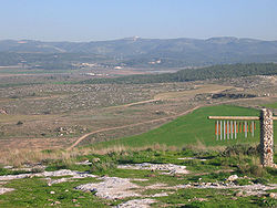
The Ayalon Valley has been an important route connecting the coastal plain and Jerusalem for generations. Due to its location, several battles were fought in its vicinity. The Hebrew Bible gives the valley its name from Ayalon, a city that the Tribe of Dan possessed before their migration to the north. In the modern period, ancient Ayalon was identified with the former village of Yalo at the base of the Bethoron pass, which preserved the ancient, biblical name. [1]

Today, the Ayalon Valley is home to several kibbutzim and moshavim , including Sha'alvim, Mishmar Ayalon, Nahshon, and Kfar Bin Nun. The valley is also home to Canada Park, a national park, the Yad La-Shiryon (Armored Corps Museum), Mini Israel, the Latrun Monastery and Emmaus Nicopolis, an archeological site commonly identified with Emmaus of the New Testament.

History

In the Tell el-Amarna letters, written during the last twelve years of Pharaoh Akhenaten and the first regnal year of Tutankhamun (14th century BCE), Abdi-Heba speaks of the destruction of the "city of Ajalon" by the invaders, [2] and describes himself as "afflicted, greatly afflicted" by the calamities that had come on the land, urging the king of Egypt to hasten to his help. This event may have been connected to an attack of the Amorites, before the arrival of the Israelites under Joshua. But since the valley stretches as far to the west as to a point halfway between Sha'alvim and Latrun, the city referenced in these letters may have been any settlement in the valley.

Ajalon is mentioned in the accounts of an invasion of Canaan by the Egyptian king Sheshonk I of Egypt in the 10th century BCE. [3]

Joshua's battle

The Valley of Ayalon was first mentioned in the Book of Joshua as where Joshua defeated five Amorite kings. Following his midnight march to rescue the city of Gibeon from the coalition led by the King of Jebus (Jerusalem), Joshua pursued the coalition eastward, down through the descent of Beth-horon, and then southward across the Valley of Ajalon. To allow the Israelites to complete the rout before nightfall, Joshua asked the Lord to lengthen the day by uttering the command: "Sun, stand thou still on Gibeon; and thou, Moon, in the valley of Aijalon". Joshua 10:11–14 records that God cooperated with Joshua's request.

Tribe of Dan

Following the conquest, the city of Ajalon was apportioned to the Tribe of Dan (Joshua 19:42) and was designated as one of the Levitical cities given to the Kohathites (Joshua 21:24 and 1 Chronicles 6:69). In spite of Joshua's initial victory in the Valley of Ajalon, the Amorites continued to live in the city of Ajalon (Judges 1:34–35). Constant Philistine pressure to control the valleys of the Shephelah forced the tribe of Dan to retreat westward, reducing the extent of their territory. Eventually, the Danites abandoned their initial inheritance in the Aijalon area and moved to the extreme northern part of Israel, settling in the city of Laish, which they renamed Dan (Judges 18).

The location was also the site of a great victory over the Philistines by King Saul and his son Jonathan. After a daring attack by Jonathan on the Philistine garrison at Michmash, they pursued the Philistines to Aijalon, a distance of fifteen miles (1 Samuel 14:31). In later years, Aijalon was inhabited by Ephraimites and Benjamites (1 Chronicles 6:69 and 1 Chronicles 8:13).

After the kingdom divided, Ajalon became the boundary between the kingdoms of Judah and Israel. Rehoboam, the first king of Judah, fortified the city of Aijalon, supplying officers, weapons and food provisions (2 Chronicles 11:5–12).

Identification

Ajalon's identification with Yalo was made by Edward Robinson during his travels in Palestine in 1838. Using the works of Jerome and Eusebius of Caesarea, who describe Aijalon as being two Roman miles from Nicopolis, while also drawing upon descriptions of Aijalon in the Old Testament and noting the philological similarities between the Arabic name and its Hebrew root, Robinson concluded that the Yalo was indeed Aijalon. [4]

Sites

Canada Park, [5] Yad La-Shiryon, [6] the International Center for the Study of Bird Migration [7] and the Latrun Monastery [8] are located in the Ayalon Valley.

Tel Aviv-Jerusalem railway bridge, Ayalon Valley Modiin-Jerusalem Railway Bridge6 02.jpg
Tel Aviv–Jerusalem railway bridge, Ayalon Valley

See also

Related Research Articles

<span class="mw-page-title-main">Zorah</span> Ancient town mentioned in the Bible

Zorah or Tzorah, was a biblical town in the Judaean Foothills. It has been identified with the former village of Sar'a, now often referred to as Tel Tzora.

<span class="mw-page-title-main">Latrun</span> Hilltop in the West Bank

Latrun is a strategic hilltop in the Latrun salient in the Ayalon Valley, and a depopulated Palestinian village. It overlooks the road between Tel Aviv and Jerusalem, 25 kilometers west of Jerusalem and 14 kilometers southeast of Ramla. It was the site of fierce fighting during the 1948 war. During the period of 1949–1967, it was occupied by Jordan at the edge of a no man's land between the armistice lines. In the 1967 war, it was occupied by Israel.

<span class="mw-page-title-main">Gibeon (ancient city)</span> Ancient city north of Jerusalem mentioned in the Bible

Gibeon was a Canaanite and later an Israelite city, which was located north of Jerusalem. According to Joshua 11:19, the pre-Israelite-conquest inhabitants, the Gibeonites, were Hivites; according to 2 Samuel 21:2, they were Amorites. The remains of Gibeon are located in the southern portion of the Palestinian village of al-Jib.

<span class="mw-page-title-main">Shephelah</span> Lowland region in south-central Israel

The Shephelah or Shfela, lit. "lowlands", is a transitional region of soft-sloping rolling hills in south-central Israel stretching over 10–15 km (6.2–9.3 mi) between the Judaean Mountains and the Coastal Plain. The different use of the term "Judean Plain", as either defining just the Coastal Plain segment stretching along the Judaean Mountains, or also including, or only referring to, the Shfela, often creates grave confusion.

<span class="mw-page-title-main">Israel Finkelstein</span> Israeli archaeologist

Israel Finkelstein is an Israeli archaeologist, professor emeritus at Tel Aviv University and the head of the School of Archaeology and Maritime Cultures at the University of Haifa. Finkelstein is active in the archaeology of the Levant and is an applicant of archaeological data in reconstructing biblical history. He is also known for applying the exact and life sciences in archaeological and historical reconstruction. Finkelstein is the current excavator of Megiddo, a key site for the study of the Bronze and Iron Ages in the Levant.

<span class="mw-page-title-main">Emmaus</span> Small village near Jerusalem

Emmaus is a town mentioned in the Gospel of Luke of the New Testament. Luke reports that Jesus appeared, after his death and resurrection, before two of his disciples while they were walking on the road to Emmaus.

<span class="mw-page-title-main">Bethoron</span> Biblical town

Bethoron, also Beth-Horon, was the name of two adjacent ancient towns strategically located on the Gibeon–Aijalon road, guarding the "ascent of Beth-Horon". The towns are mentioned in the Hebrew Bible and in other ancient sources: Upper Bethoron appears in Joshua 16:5 and Lower Bethoron in Joshua 16:3 and 1 Chronicles 7:24 and I Maccabees 3:16.

<span class="mw-page-title-main">Gath (city)</span> Ancient city and archaeological site

Gath or Gat was one of the five cities of the Philistine pentapolis during the Iron Age. It was located in northeastern Philistia, close to the border with Judah. Gath is often mentioned in the Hebrew Bible and its existence is confirmed by Egyptian inscriptions. Already of significance during the Bronze Age, the city is believed to be mentioned in the El-Amarna letters as Gimti/Gintu, ruled by the two Shuwardata and 'Abdi-Ashtarti. Another Gath, known as Ginti-kirmil also appears in the Amarna letters.

<span class="mw-page-title-main">Canada Park</span> National park in the Occupied West Bank

Canada Park is an Israeli national park stretching over 7,000 dunams (7km2), and extending from No man's land into the West Bank. The park is located north of Highway 1, and is situated near the Ayalon Valley, between the Latrun Interchange and Sha'ar HaGai.

<span class="mw-page-title-main">Keilah</span> Biblical settlement

Keilah, meaning Citadel, was a city in the lowlands of Judah. It is now a ruin, known as Kh. Qeila, near the modern village of Qila, 7 miles (11 km) east of Beit Gubrin, and about 3 kilometres (1.9 mi) west of Kharas.

<span class="mw-page-title-main">Sha'alvim</span> Kibbutz in central Israel

Sha'alvim is a religious kibbutz in central Israel and one of only two affiliated with Poalei Agudat Yisrael. Located near the city of Modi'in-Maccabim-Re'ut, it falls under the jurisdiction of Gezer Regional Council. In 2021 it had a population of 1,886.

<span class="mw-page-title-main">Imwas</span> Village in Ramle, Mandatory Palestine

Imwas or Emmaus, known in classical times as Nicopolis, was a Palestinian village located 12 kilometres (7.5 mi) southeast of the city of Ramla and 26 kilometres (16 mi) from Jerusalem in the Latrun salient of the West Bank. It is traditionally identified with the biblical Emmaus.

Mishmar Ayalon is a moshav in central Israel. Located between Latrun and Ramla on the old Jerusalem-Tel Aviv road, it falls under the jurisdiction of Gezer Regional Council. In 2021 it had a population of 573.

<span class="mw-page-title-main">Yalo</span> Village in Ramle, Mandatory Palestine

Yalo was a Palestinian Arab village located 13 kilometres southeast of Ramla. Identified by Edward Robinson as the ancient Canaanite and Israelite city of Aijalon. During the Middle Ages, it was the site of a Crusader castle, Castrum Arnaldi.

<span class="mw-page-title-main">Salbit</span> Place in Ramle, Mandatory Palestine

Salbit was a Palestinian Arab village located 12 kilometers (7.5 mi) southeast of al-Ramla. Salbit was depopulated during the 1948 Arab–Israeli War after a military assault by Israeli forces. The Israeli locality of Shaalvim was established on the former village's lands in 1951.

Moresheth-Gath, also Moreshet-Gat, was a town of the tribe of Judah in ancient Israel mentioned in the Bible. It was located in the Shephelah region between Lachish and Achzib.

<span class="mw-page-title-main">Latrun Interchange</span>

Latrun Interchange is a key road interchange of Israel, located in the Latrun Salient in the Israeli occupied West Bank. It lies on the route between Jerusalem and Tel Aviv, at the intersection of Highway 1 and Highway 3.

<span class="mw-page-title-main">Jarmuth</span> Archaeological ruin south of Beit Shemesh

Jarmuth, Hebrew: Yarmut (יַרְמוּת), was the name of two cities in the land of Canaan.

<span class="mw-page-title-main">Joshua 9</span> Book of Joshua, chapter 9

Joshua 9 is the ninth chapter of the Book of Joshua in the Hebrew Bible or in the Old Testament of the Christian Bible. According to Jewish tradition the book was attributed to the Joshua, with additions by the high priests Eleazar and Phinehas, but modern scholars view it as part of the Deuteronomistic History, which spans the books of Deuteronomy to 2 Kings, attributed to nationalistic and devotedly Yahwistic writers during the time of the reformer Judean king Josiah in 7th century BC. This chapter focuses on the deception by the people of Gibeon to avoid annihilation by having a treaty with the people of Israel under the leadership of Joshua, a part of a section comprising Joshua 5:13–12:24 about the conquest of Canaan.

References

  1. J. D. Douglas; Merrill C. Tenney (3 May 2011). Zondervan Illustrated Bible Dictionary. Harper Collins. p. 45. ISBN   978-0-310-49235-1.
  2. Claude Reignier Conder (1894). The Tell Amarna Tablets (2nd ed.).
  3. Frank Clancy (1999). "Shishak/Shoshenq's Travels". Journal for the Study of the Old Testament. 24 (3): 3–23. doi:10.1177/030908929902408601. S2CID   170437101.
  4. Robinson and Smith, 1860, p. 253-254.
  5. "Ayalon Canada Park - Biblical and Modern Israel".
  6. "אתר יד לשריון - חיל השריון מאז ועד היום".
  7. "Israel: The Bird's Eye View". Archived from the original on 2014-04-19. Retrieved 2014-04-18.
  8. "HOLY WINE - Domain de Latroune Wine". www.holy-wine.com. Archived from the original on 30 November 2022. Retrieved 2023-03-18.

Bibliography

31°50′25″N35°01′21″E / 31.84028°N 35.02250°E / 31.84028; 35.02250