Babice nad Svitavou | |
|---|---|
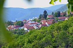 View of Babice nad Svitavou | |
 Flag  Coat of arms | |
 Babice nad Svitavou Location in the Czech Republic | |
| Coordinates: 49°17′0″N16°41′46″E / 49.28333°N 16.69611°E | |
| Country | |
| Region | South Moravian |
| District | Brno-Country |
| First mentioned | 1365 |
| Area | |
• Total | 17.42 km2 (6.73 sq mi) |
| Elevation | 420 m (1,380 ft) |
| Population (2025-01-01) [1] | |
• Total | 1,462 |
| • Density | 84/km2 (220/sq mi) |
| Time zone | UTC+1 (CET) |
| • Summer (DST) | UTC+2 (CEST) |
| Postal code | 664 01 |
| Website | www |
Babice nad Svitavou is a municipality and village in Brno-Country District in the South Moravian Region of the Czech Republic. It has about 1,500 inhabitants. It lies on the Svitava River.