Prace, Czech Republic

Last updated
Prace
Mohyla miru 1.jpg
Cairn of Peace Monument
Prace flag.svg
Znak obce Prace v2.svg
Relief Map of Czech Republic.png
Red pog.svg
Prace
Location in the Czech Republic
Coordinates: 49°8′28″N16°45′55″E / 49.14111°N 16.76528°E / 49.14111; 16.76528
CountryFlag of the Czech Republic.svg  Czech Republic
Region South Moravian
District Brno-Country
First mentioned1274
Area
  Total4.71 km2 (1.82 sq mi)
Elevation
245 m (804 ft)
Population
 (2023-01-01) [1]
  Total957
  Density200/km2 (530/sq mi)
Time zone UTC+1 (CET)
  Summer (DST) UTC+2 (CEST)
Postal code
664 58
Website www.praceubrna.cz

Prace (German : Pratzen) is a municipality and village in Brno-Country District in the South Moravian Region of the Czech Republic. It has about 1,000 inhabitants.

Contents

Geography

Prace is located about 12 kilometres (7 mi) southeast of Brno. It lies in the Dyje–Svratka Valley. The highest point is the hill Pracký kopec at 325 m (1,066 ft) above sea level.

History

The first written mention of Prace is from 1274. [2]

The pivotal action in the Battle of Austerlitz was fought over a nearby elevated area called Pracký kopec.

Demographics

Historical population
YearPop.±%
1869589    
1880842+43.0%
1890837−0.6%
1900845+1.0%
1910873+3.3%
YearPop.±%
1921895+2.5%
1930966+7.9%
1950866−10.4%
1961931+7.5%
1970884−5.0%
YearPop.±%
1980832−5.9%
1991785−5.6%
2001847+7.9%
2011884+4.4%
2021911+3.1%
Source: Censuses [3] [4]

Transport

There are no railways or major roads passing through the municipality.

Sights

Church of the Exaltation of the Holy Cross Prace, kostel (0039).jpg
Church of the Exaltation of the Holy Cross

The main landmark of Prace is the Church of the Exaltation of the Holy Cross. It was originally a Baroque church, rebuilt in the Neoclassical style. [5]

The Cairn of Peace Memorial in Prace memorializes those killed in the Battle of Austerlitz. It is an architecturally valuable Gesamtkunstwerk , built in the Art Nouveau style in 1910–1912. The monument symbolizes an ancient Slavic burial mound and consists of a four-sided truncated pyramid with a height of 26 metres (85 ft). [6]

A cultural monument is the mass grave of about 800 Russian soldiers who died in the Battle of Austerlitz. [7]

Related Research Articles

<span class="mw-page-title-main">Újezd u Brna</span> Town in South Moravian, Czech Republic

Újezd u Brna is a town in Brno-Country District in the South Moravian Region of the Czech Republic. It has about 3,400 inhabitants.

<span class="mw-page-title-main">Valy (Pardubice District)</span> Municipality in Pardubice, Czech Republic

Valy is a municipality and village in Pardubice District in the Pardubice Region of the Czech Republic. It has about 500 inhabitants.

<span class="mw-page-title-main">Říčany (Brno-Country District)</span> Municipality in South Moravian, Czech Republic

Říčany is a municipality and village in Brno-Country District in the South Moravian Region of the Czech Republic. It has about 2,100 inhabitants.

<span class="mw-page-title-main">Domašov nad Bystřicí</span> Municipality in Olomouc, Czech Republic

Domašov nad Bystřicí is a municipality and village in Olomouc District in the Olomouc Region of the Czech Republic. It has about 500 inhabitants.

<span class="mw-page-title-main">Těšany</span> Municipality in South Moravian, Czech Republic

Těšany is a municipality and village in Brno-Country District in the South Moravian Region of the Czech Republic. It has about 1,300 inhabitants.

<span class="mw-page-title-main">Brno-Country District</span> District in South Moravian, Czech Republic

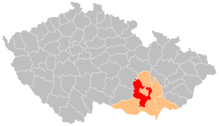
Brno-Country District is a district in the South Moravian Region of the Czech Republic. Its capital is the city of Brno. The most populated town of the district is Kuřim. The district is made up of 187 municipalities, which is the highest number within all districts of the Czech Republic.

<span class="mw-page-title-main">Tvarožná (Brno-Country District)</span> Municipality in South Moravian, Czech Republic

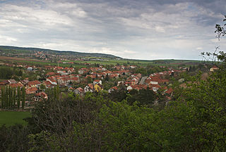
Tvarožná is a municipality and village in Brno-Country District in the South Moravian Region of the Czech Republic. It has about 1,300 inhabitants.

<span class="mw-page-title-main">Boleradice</span> Market town in South Moravian, Czech Republic

Boleradice is a market town in Břeclav District in the South Moravian Region of the Czech Republic. It has about 900 inhabitants.

<span class="mw-page-title-main">Bulhary (Břeclav District)</span> Municipality in South Moravian, Czech Republic

Bulhary is a municipality and village in Břeclav District in the South Moravian Region of the Czech Republic. It has about 700 inhabitants. Bulhary is partly located within the Lednice–Valtice Cultural Landscape, a UNESCO World Heritage Site.

<span class="mw-page-title-main">Konstantinovy Lázně</span> Municipality in Plzeň, Czech Republic

Konstantinovy Lázně is a spa municipality and village in Tachov District in the Plzeň Region of the Czech Republic. It has about 900 inhabitants.

<span class="mw-page-title-main">Lysice</span> Market town in South Moravian, Czech Republic

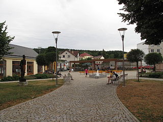
Lysice is a market town in Blansko District in the South Moravian Region of the Czech Republic. It has about 1,900 inhabitants.

<span class="mw-page-title-main">Nosislav</span> Market town in South Moravian, Czech Republic

Nosislav is a market town in Brno-Country District in the South Moravian Region of the Czech Republic. It has about 1,400 inhabitants.

<span class="mw-page-title-main">Ořechov (Brno-Country District)</span> Municipality in South Moravian, Czech Republic

Ořechov is a municipality and village in Brno-Country District in the South Moravian Region of the Czech Republic. It has about 2,900 inhabitants.

<span class="mw-page-title-main">Předklášteří</span> Municipality in South Moravian, Czech Republic

Předklášteří is a municipality and village in Brno-Country District in the South Moravian Region of the Czech Republic. It has about 1,400 inhabitants.

<span class="mw-page-title-main">Sokolnice</span> Municipality in South Moravian, Czech Republic

Sokolnice is a municipality and village in Brno-Country District in the South Moravian Region of the Czech Republic. It has about 2,300 inhabitants.

<span class="mw-page-title-main">Vranovice (Brno-Country District)</span> Municipality in South Moravian, Czech Republic

Vranovice is a municipality and village in Brno-Country District in the South Moravian Region of the Czech Republic. It has about 2,400 inhabitants.

<span class="mw-page-title-main">Bohdalice-Pavlovice</span> Municipality in South Moravian, Czech Republic

Bohdalice-Pavlovice is a municipality in Vyškov District in the South Moravian Region of the Czech Republic. It has about 900 inhabitants.

<span class="mw-page-title-main">Brankovice</span> Market town in South Moravian, Czech Republic

Brankovice is a market town in Vyškov District in the South Moravian Region of the Czech Republic. It has about 900 inhabitants.

<span class="mw-page-title-main">Hvězdlice</span> Market town in South Moravian, Czech Republic

Hvězdlice is a market town in Vyškov District in the South Moravian Region of the Czech Republic. It has about 600 inhabitants.

<span class="mw-page-title-main">Křenovice (Vyškov District)</span> Municipality in South Moravian, Czech Republic

Křenovice is a municipality and village in Vyškov District in the South Moravian Region of the Czech Republic. It has about 2,000 inhabitants.

References

  1. "Population of Municipalities – 1 January 2023". Czech Statistical Office. 2023-05-23.
  2. "Historie a současnost obce" (in Czech). Obec Prace. Retrieved 2021-11-12.
  3. "Historický lexikon obcí České republiky 1869–2011 – Okres Brno-venkov" (in Czech). Czech Statistical Office. 2015-12-21. pp. 9–10.
  4. "Population Census 2021: Population by sex". Public Database. Czech Statistical Office. 2021-03-27.
  5. "Kostel Povýšení sv. Kříže" (in Czech). National Heritage Institute. Retrieved 2024-04-17.
  6. "Pomník Mohyla míru" (in Czech). National Heritage Institute. Retrieved 2024-04-17.
  7. "Hromadný hrob z bitvy u Slavkova" (in Czech). National Heritage Institute. Retrieved 2024-04-17.