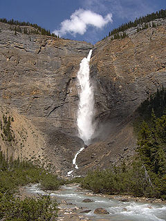
Takakkaw Falls is a waterfall located in Yoho National Park, near Field, British Columbia in Canada. The falls have a total height of 373 metres (1,224 ft), making it the 2nd tallest waterfall in Canada. The main drop of the waterfall has a height of 254 metres (833 ft).

Skógar, literally forests, is a small Icelandic village with a population of roughly 25 located at the south of the Eyjafjallajökull glacier, in the municipality of Rangárþing eystra.

Uvas Canyon County Park is a 1,147-acre (464 ha) natural park located in upper Uvas Canyon on the eastern side of the Santa Cruz Mountains, west of Morgan Hill, California. The park has several small waterfalls, some of which flow perennially, that feed into tributaries confluent with Uvas Creek. The park is part of the Santa Clara County Parks System, and facilitates picnics, hiking and overnight camping. It is one of the few parks in the area that allows dogs in the campgrounds.
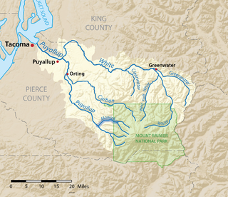
The Mowich River is a river in the U.S. state of Washington. Its watershed drains a portion of the western side of Mount Rainier, part of the Cascade Range. The river has two main headwater branches, the South Mowich River and the North Mowich River. The South Mowich is significantly larger and sometimes considered the main river. The Mowich and its tributaries drain several of Mount Rainier's glaciers. The upper portion of its watershed is contained within Mount Rainier National Park. The river flows into the Puyallup River in the foothills west of Mount Rainier.
Green Lake Falls is a large, very difficult to access waterfall located a short distance below the outlet of remote Green Lake, in North Cascades National Park, Whatcom County, Washington. It is 979 feet (298 m) high & averages 150 feet (46 m) wide and flows year-round. It has several tiers, including a 300 foot slide and a 500 foot plunge.
Shoestring Falls is a waterfall, about 1,000 feet (300 m) high, fed by an unnamed stream coming from Malachite Glacier in the Alpine Lakes Wilderness Area, King County, Washington. It is 20 feet (6.1 m) in breadth and flows year-round, but is at peak flow May to July. It drops down the mountainside in five distinct tiers, with the two main tiers totaling about 700 feet (210 m). It is at 47.63127°N 121.31881°W.
Blum Basin Falls is a waterfall in Whatcom County, in the U.S. state of Washington. It is located in North Cascades National Park on the headwaters of Blum Creek, a tributary of the Baker River. Fed by two small retreating glaciers and several snowfields on the southern side of Mount Blum, the waterfall is formed by the largest meltwater stream that feeds the mainstem of Blum Creek. The falls tumble 1,680 feet (510 m) down a high glacial headwall several miles within the national park in two distinct stages; the first is a series of slides over rounded rock, above the tree line, and the second is a series of near-vertical plunges to the forested valley below. Although most of the falls is clearly visible, parts of it are obscured by tall pines that grow at its base. There is no trail leading to the waterfall.
There are four prominent waterfalls in the basin of a short tributary of Sulphide Creek, on the southeast flanc of 9,127-foot (2,781m) Mount Shuksan in North Cascades National Park, Washington. Seahpo Peak Falls and Cloudcap Falls, the taller two of the three, are located on separate streams that converge and plunge over Rockflow Canyon Falls. The unnamed outlet stream from these waterfalls flows into Sulphide Creek, which flows into the Baker River. Another waterfall is Jagged Ridge Falls, on a tributary of the unnamed stream.
Berdeen Falls is a series of three waterfalls located in Whatcom County, Washington. The 850-foot (260 m) falls are on a stretch of Bacon Creek downstream of Berdeen Lake.The drops include a 400-foot (120 m) horsetail, a 200-foot (61 m) bedrock slide, and a 250-foot (76 m) plunge waterfall.
Blum Creek is a small glacial tributary of the Baker River in Washington State, in the United States. It is sourced from the Hagan Glacier and another unnamed glacier on the north face of Mount Blum, and flows approximately 1.5 miles (2.4 km) from there to its mouth at the Baker River. Hagan Glacier is located below Mount Blum and the creek is also fed by runoff from the Blum Lakes, a set of six lakes south of Bacon Peak. The creek joins the Baker River two drainages downstream of Sulphide Creek, another Baker River glacial tributary. Blum Creek forms the waterfall Blum Basin Falls as it tumbles down a 1,680-foot (510 m) glacial cliff. The creek's watershed is an overwintering location for the local Rocky mountain goats.

Akuliarusiarsuup Kuua is a river and valley of the same name in the Qeqqata municipality in central-western Greenland. Its source is the meltwater outflow from Russell Glacier, an outflow of the Greenland ice sheet. The river is a tributary of Qinnguata Kuussua, the main river in the Kangerlussuaq area. For most of its run, the river flows very slowly through the sandur basin of the valley, forming meanders amongst large fields of glacial silt quicksand. The climate is polar continental, with the area receiving very little rainfall.
Big Heart Falls is a waterfall on the outlet stream of Big Heart Lake, which eventually flows into the Skykomish River, in King County, Washington. It is located between the outlet of Big Heart Lake and the inlet of Delta Lake. The falls are said to drop approximately 1,268 feet (386 m).

Eagle Creek is a tributary of the Columbia River in Multnomah and Hood River counties in the U.S. state of Oregon. It cuts through a narrow canyon in its 3,200 feet (980 m) descent to the Columbia River Gorge and is known for its concentration of 13 waterfalls in about 5 miles (8.0 km) distance. Eight major falls are on Eagle Creek and the East Fork Eagle Creek itself, while five are on its tributaries.
There are multiple waterfalls in the basin of the North Fork Cascade River, a river in the North Cascades of Washington that drains to the Cascade River. Many of these are taller than the more famous waterfalls in North America, but do not receive much attention due to their remoteness.
Whinnimic Falls is a waterfall in the headwaters of Lemah Creek in the Alpine Lakes Wilderness Area. It is set in a narrow valley below Lemah Mountain. The falls are one of two in the valley, the other being the smaller Upper Lemah Valley Falls. Whinnimic Falls plunges about 350 feet (110 m) off a vertical cliff, onto a valley floor dotted with ponds and grassy meadows. The stream heads in two tarns and the remains of a small glacier.

Sulphide Creek is a 2.5-mile (4.0 km) glacial tributary of the Baker River in Whatcom County in the U.S. state of Washington, draining a steep and narrow canyon on the southeast flank of Mount Shuksan, inside North Cascades National Park. Although called a creek, it is river-like due to its high volume. The creek is fed by the "massive" Sulphide and Crystal glaciers above Sulphide Lake and it runs east collecting several small tributaries before flowing into the Baker River at elevation 869 feet (265 m). There are several very tall waterfalls occurring on the creek and its tributaries, the largest of which is Sulphide Creek Falls.
Bacon Creek is a glacial stream in Whatcom County, Washington. It originates in a glacier on the southwest face of Bacon Peak, flows into a small tarn, then flows over the Berdeen Falls. At the base of the waterfall, the creek turns southeast and joins the Skagit River near and discharges into the Skagit River near Marblemount.

Ahern Glacier is in Glacier National Park in the U.S. state of Montana. The glacier was named after George Patrick Ahern. Ahern Glacier is situated on a ridge between Ipasha Peak to the north and Ahern Peak to the south at an elevation between 8,800 feet (2,700 m) and 8,000 feet (2,400 m) above sea level, immediately east of the Continental Divide. Meltwater from the glacier feeds Ahern Glacier Falls, a waterfall which descends an estimated 1,680 feet (510 m) in one sheer drop to a talus slope below en route to Helen Lake. Between 1966 and 2005, Ahern Glacier lost 13 percent of its surface area.
Green Lake Glacier is in North Cascades National Park in the U.S. state of Washington and is immediately northeast of Bacon Peak. Green Lake Glacier descends from a ridge extending from the east of Bacon Peak. The glacier forms two tongues descending to the north of the ridge from 6,600 to 5,500 ft. The ridge is an arête which separates Green Lake Glacier from Diobsud Creek Glacier to the south. Meltwater from the glacier spills over Bacon Lake Falls en route to Green Lake.
Green Lake is located in North Cascades National Park, in the U. S. state of Washington. Situated 1.5 mi (2.4 km) northeast of Bacon Peak, Green Lake receives some runoff from Green Lake Glacier which empties into the lake after plunging 375 ft (114 m) over Bacon Lake Falls. Another series of waterfalls lie below Green Lake and are known as Green Lake Falls which drop another 979 ft (298 m).


