
Uvas Canyon County Park is a 1,147-acre (464 ha) natural park located in upper Uvas Canyon on the eastern side of the Santa Cruz Mountains, west of Morgan Hill, California. The park has several small waterfalls, some of which flow perennially, that feed into tributaries confluent with Uvas Creek. The park is part of the Santa Clara County Parks System, and facilitates picnics, hiking and overnight camping. It is one of the few parks in the area that allows dogs in the campgrounds.
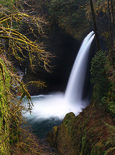
Metlako Falls is a waterfall on Eagle Creek in the Columbia River Gorge National Scenic Area in Hood River County, Oregon, United States. It is the furthest downstream of the major waterfalls on Eagle Creek. Like upstream Punch Bowl Falls, Metlako is also in the form of a punchbowl. The falls is 101 feet (31 m) tall, though people have measured it anywhere from 100 feet (30 m) to 150 feet (46 m) tall. It is the upstream limit for salmon spawning in Eagle Creek.

Bridal Veil Falls is a 1,328-foot (405 m) waterfall that flows from Lake Serene directly to the South Fork Skykomish River on the creek of the same name in the U.S. state of Washington. It is a perennial 150-foot (46 m) wide drop with four tiers, two of which are clearly visible. It is at 47.78950°N 121.56924°W.
Shoestring Falls is a waterfall, about 1,000 feet (300 m) high, fed by an unnamed stream coming from Malachite Glacier in the Alpine Lakes Wilderness Area, King County, Washington. It is 20 feet (6.1 m) in breadth and flows year-round, but is at peak flow May to July. It drops down the mountainside in five distinct tiers, with the two main tiers totaling about 700 feet (210 m). It is at 47.63127°N 121.31881°W.

Shellburg Falls is a waterfall that measures 100 feet (30 m) high and has an average breadth of 10 feet (3.0 m) in the watershed of Stout Creek. It is in the Santiam State Forest in Oregon, on a small stream named Shellburg Creek, which relies on rainfall to flow. The falls flow over an overhanging Basalt ledge. It is about 500 feet (150 m) upstream from Lower Shellburg Falls.
There are four prominent waterfalls in the basin of a short tributary of Sulphide Creek, on the southeast flanc of 9,127-foot (2,781m) Mount Shuksan in North Cascades National Park, Washington. Seahpo Peak Falls and Cloudcap Falls, the taller two of the three, are located on separate streams that converge and plunge over Rockflow Canyon Falls. The unnamed outlet stream from these waterfalls flows into Sulphide Creek, which flows into the Baker River. Another waterfall is Jagged Ridge Falls, on a tributary of the unnamed stream.
Wy'east Falls is a waterfall on a small tributary of Eagle Creek in Hood River County, Oregon, U.S.
Walupt Creek Falls is a relatively obscure, but massive waterfall on Walupt Creek, a large tributary of the Cispus River in Lewis County, Washington, at an elevation of 3,500 feet (1,100 m).
The falls cascade 221 feet (67 m) down a bedrock cliff in two tiers, with an average breadth of 204 feet (62 m), a maximum breadth of 267 feet (81 m) and an average flow of over 150 cubic feet (4.2 m3) per second. The creek begins the drop by falling down a 10 feet (3.0 m) cascade, then impacts a large, bell-shaped dome and spreads into a wide fan, dropping 200 feet (61 m). The final drop is a gently sloping slide that flows directly into the Cispus River. The feeder river, Walupt Creek, is sourced directly from Walupt Lake which provides a consistent flow throughout the year. The drainage basin of the river is also fairly large.
Comet Falls is a tall waterfall located on Van Trump Creek in Pierce County, Washington. The falls are thought to be the best in the Mount Rainier region.

Christine Falls is a waterfall on Van Trump Creek in Pierce County, Washington. The falls are 69 feet (21 m) feet high and are best known for the Christine Falls Bridge spanning the lower drop. The upper drop is 32 feet (9.8 m) high and is almost impossible to film in tandem with the oft-photographed 37-foot (11 m) lower tier. The lower tier is probably one of the most commonly photographed locations in the Mount Rainier area.
Big Heart Falls is a waterfall on the outlet stream of Big Heart Lake, which eventually flows into the Skykomish River, in King County, Washington. It is located between the outlet of Big Heart Lake and the inlet of Delta Lake. The falls are said to drop approximately 1,268 feet (386 m).

Kautz Creek is a tributary of the Nisqually River, flowing from the Kautz Glacier, with its watershed in the Mount Rainier National Park of Washington. It drains southwest from Mount Rainier for about 6 miles (9.7 km) before it joins the Nisqually River near Mount Rainier Highway. It is notable for being a severe flooding hazard due to the volume of summer glacier melt and its frequently changing course. The 400-foot (120 m) Kautz Creek Falls on the headwaters of the creek was formed by the retreat of the Kautz Glacier in the past 50 years.

Eagle Creek is a tributary of the Columbia River in Multnomah and Hood River counties in the U.S. state of Oregon. It cuts through a narrow canyon in its 3,200 feet (980 m) descent to the Columbia River Gorge and is known for its concentration of 13 waterfalls in about 5 miles (8.0 km) distance. Eight major falls are on Eagle Creek and the East Fork Eagle Creek itself, while five are on its tributaries.
There are multiple waterfalls in the basin of the North Fork Cascade River, a river in the North Cascades of Washington that drains to the Cascade River. Many of these are taller than the more famous waterfalls in North America, but do not receive much attention due to their remoteness.
Sydney Falls, more commonly called Kotsuck Creek Falls or Kotsuck Falls, is a waterfall in the Mount Rainier National Park in the U.S. state of Washington.
The Paradise River is known for having a total of 8 major waterfalls.

There are at least 120 named waterfalls in Montana.
A waterfall is a place where flowing water rapidly drops in elevation as it flows over a steep region or a cliff. Waterfalls are most commonly formed when a river is young.
The Koma Kulshan Project is a 13.3 MW run-of-the-river hydroelectric generation facility on the slopes of Mount Baker, a stratovolcano in Washington state's North Cascades. The project commenced commercial operation in October 1990, and is owned by a Covanta Energy–Atlantic Power joint venture. It supplies Puget Sound Energy via a Power Supply Agreement (PSA) contract. Its single turbine is a Pelton wheel supplied by Sulzer Escher Wyss.


