
Mount Baker, also known as Koma Kulshan or simply Kulshan, is a 10,781 ft (3,286 m) active glacier-covered andesitic stratovolcano in the Cascade Volcanic Arc and the North Cascades of Washington in the United States. Mount Baker has the second-most thermally active crater in the Cascade Range after Mount St. Helens. About 30 miles (48 km) due east of the city of Bellingham, Whatcom County, Mount Baker is the youngest volcano in the Mount Baker volcanic field. While volcanism has persisted here for some 1.5 million years, the current volcanic cone is likely no more than 140,000 years old, and possibly no older than 80–90,000 years. Older volcanic edifices have mostly eroded away due to glaciation.

Bellingham is the most populous city in, and county seat of Whatcom County in the U.S. state of Washington. It lies 21 miles (34 km) south of the U.S.–Canada border and in between Vancouver, British Columbia and Seattle.

Whatcom County is a county located in the northwestern corner of the U.S. state of Washington, bordered by the Lower Mainland of British Columbia to the north, Okanogan County to the east, Skagit County to the south, San Juan County across Rosario Strait to the southwest, and the Strait of Georgia to the west. Its county seat and largest population center is the coastal city of Bellingham, comprising the Bellingham, WA Metropolitan Statistical Area, and as of the 2020 census, the county's population was 226,847.

Sumas is a city in Whatcom County, Washington, United States. It had a population of 1,307 as of the 2010 census. Sumas is located adjacent to the Canada–U.S. border and borders the city of Abbotsford, British Columbia. The Sumas-Huntingdon port of entry at the north end of State Route 9 operates 24 hours a day. Sumas shares Nooksack Valley School District with the cities of Nooksack and Everson. It is the northernmost settlement on Washington State Route 9.
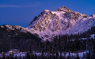
Mount Shuksan is a glaciated massif in the North Cascades National Park. Shuksan rises in Whatcom County, Washington immediately to the east of Mount Baker, and 11.6 miles (18.7 km) south of the Canada–US border. The mountain's name Shuksan is derived from the Lummi word [šéqsən], said to mean "high peak". The highest point on the mountain is a three-sided peak known as Summit Pyramid.

The Nooksack River is a river in western Whatcom County of the northwestern U.S. state of Washington, draining extensive valley systems within the North Cascades around Mount Shuksan, Mount Baker and the Twin Sisters, and a portion of Fraser Lowland south of the Canada–United States border.
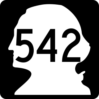
State Route 542 (SR 542) is a 57.24-mile-long (92.12 km) state highway in the U.S. state of Washington, serving Mount Baker in Whatcom County. SR 542 travels east as the Mount Baker Highway from an interchange with Interstate 5 (I-5) in Bellingham through the Nooksack River valley to the Mt. Baker Ski Area at Austin Pass. It serves as the main highway to Mount Baker and the communities of Deming, Kendall, and Maple Falls along the Nooksack River. The highway was constructed in 1893 by Whatcom County as a wagon road between Bellingham and Maple Falls and was added to the state highway system as a branch of State Road 1 in 1925. The branch was transferred to Primary State Highway 1 (PSH 1) during its creation in 1937 and became SR 542 during the 1964 highway renumbering.

Mount Baker Wilderness is a 119,989-acre (48,558 ha) wilderness area within the Mount Baker-Snoqualmie National Forest in the western Cascade Range of northern Washington state. Its eastern border is shared with the boundary of the Stephen Mather Wilderness and North Cascades National Park for a distance of 40 miles. The wilderness extends from State Route 20 north to the Canada–US border. On the west, it is bounded by the foothills of the Puget Sound lowlands.

The historical Winchester Lookout, located in the North Cascades in the U.S. state of Washington, provides views of the Northern Picket Range, Mount Baker, Mount Shuksan, Mount Larrabee, and Canadian peaks. The steep snowfields usually require an ice-axe well into July. The Twin Lakes road may not be passable to the trailhead which will add 2 miles (3.2 km) to the hike. Volunteers from the Mount Baker Club maintain the lookout with 2 work parties per year.

The Black Buttes, also known historically as the Sawtooth Rocks, make up an extinct stratovolcano in the Cascade Volcanic Arc in Whatcom County, Washington, United States. Glacially eroded remnants of this volcano rise above the Deming Glacier, part of the glacier system of the nearby volcano, Mount Baker. There are three major peaks — Colfax, Lincoln, and Seward — all of which can be climbed.

State Route 544 is a state highway in northern Whatcom County, Washington, United States. It runs east–west for 9 miles (14 km) near the Canadian border, connecting SR 539 near Lynden to Everson and a junction with SR 9 in Nooksack.

Twin Sisters Mountain, commonly called the Twin Sisters, is a mountain in the U.S. state of Washington. Part of the Cascade Range, it lies just southwest of Mount Baker. Of its two main peaks, South Twin is higher, with a summit elevation above 7,004 feet (2,135 m). The summit of North Twin is above 6,644 feet (2,025 m). There are several glaciers on the northeast slopes of Twin Sisters Mountain.
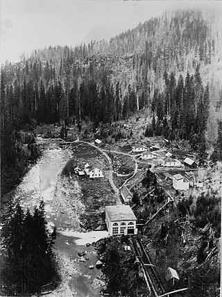
The 1500-kilowatt capacity Nooksack Falls Hydroelectric Power Plant was constructed at Nooksack Falls on the Nooksack River in 1906 by Stone & Webster, which is the second oldest operating facility in western Washington. The plant operated for over 90 years and ceased operation in 1997 due to a fire which destroyed the generator. The generator was replaced in 2003 and the plant resumed operations.
The history of Bellingham, Washington, as it is now known, begins with the settling of Whatcom County in the mid-to-late 19th century.
The Ski to Sea Race (S2S), widely known as the Ski to Sea, is a seven-legged, 93-mile (150 km) long, multi-event competition held on the Sunday of Memorial Day weekend in Whatcom County. The race starts on the ski slopes of Mount Baker Ski Area, and ends at Marine Park in Fairhaven, on the shore of Bellingham Bay. The seven legs of the race are: cross-country skiing, downhill skiing or snowboarding, running, road biking, canoeing, cyclo-cross biking, and finally kayaking. The Ski to Sea Race is managed by Whatcom Events, with a race committee that includes a race director, an operations assistant, one or two chairmen to oversee each event, a volunteer coordinator along with nearly 900 volunteers.
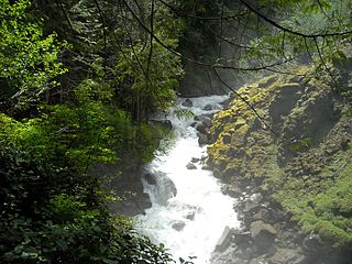
Wells Creek is a swift creek in Whatcom County, Washington. It is a tributary of the Nooksack River, joining the river just below Nooksack Falls. It is best known for having six major waterfalls along its course. Wells Creek was named for Hamilton C. Wells who prospected the area in the 1880s and 1890s.
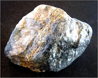
The Mount Baker gold rush occurred in Whatcom County, Washington, United States, upon the discovery of the Lone Jack Mine. The Mount Baker area was flooded with prospectors which led to the staking of many claims both patented and unpatented. The most notable mines staked soon after the Lone Jack are the Boundary Red Mountain Mine, Garget Mine, Gold Basin Mine, Silver Tip Mine, and the Evergreen Mine.
The Boundary Red Mountain Mine of Whatcom County, Washington, United States, consists of six patented lode claims survey in 1902 and patented under patent number 39545. The gold mine was discovered in 1898 and its last production year was 1946. The property is privately owned. The lode claims include Rocky draw lode, Klondike lode, Mountain Boy Lode, Glacier Lode, Climax lode, & Climax Ext No. 1 lode. Located in Whatcom County, Washington, U.S.A., the mine is approximately ½ mile south of the Canada–US border. It is within close approximation of another gold mine, the Lone Jack Mine, which shuttered operations in 1924 and later reopened in 1991.

Hannegan Peak is a 6,191-foot elevation (1,887 m) mountain summit located in the Skagit Range, which is a subset of the North Cascades in Whatcom County of Washington state. It is situated immediately north of Hannegan Pass, and 2.2 mi (3.5 km) north of Ruth Mountain in the Mount Baker Wilderness, which is managed by Mount Baker-Snoqualmie National Forest. Banning Austin and R.M. Lyle made the first ascent of Hannegan Peak in 1893 while surveying for a possible road across the Cascades over Hannegan Pass to Whatcom Pass. This peak was named in association with Hannegan Pass, which in turn was named for Tom Hannegan, State Road Commissioner at that time. Although no road was built, a four-mile trail leads hikers to the pass, and another one-mile path leads to the summit. Peaks which can be seen from the summit include Mount Shuksan, Ruth Mountain, Mineral Mountain, Mount Baker, Mount Sefrit, Mount Larrabee, Granite Mountain, Mount Chardonnay, Mount Rexford, the Picket Range, and many more.

Bearpaw Mountain is a 6,091-foot (1,857-metre) mountain summit located in Whatcom County of Washington state. It is situated less than four miles south of the Canada–United States border, on land managed by Mount Baker-Snoqualmie National Forest. The nearest higher neighbor is Church Mountain, 1.8 miles (2.9 km) to the southwest, and Mount Baker rises 11.8 miles (19.0 km) to the south. Precipitation runoff from the mountain drains to the Nooksack River via Canyon Creek. Topographic relief is significant as the north aspect rises 3,100 feet (945 m) above Canyon Creek in approximately 1.5 mile. Bearpaw Mountain houses Bearpaw Mountain Lake, 650 ft elevated fishing lake.

