
Mount Baker, also known as Koma Kulshan or simply Kulshan, is a 10,781 ft (3,286 m) active glacier-covered andesitic stratovolcano in the Cascade Volcanic Arc and the North Cascades of Washington in the United States. Mount Baker has the second-most thermally active crater in the Cascade Range after Mount St. Helens. About 30 miles (48 km) due east of the city of Bellingham, Whatcom County, Mount Baker is the youngest volcano in the Mount Baker volcanic field. While volcanism has persisted here for some 1.5 million years, the current volcanic cone is likely no more than 140,000 years old, and possibly no older than 80–90,000 years. Older volcanic edifices have mostly eroded away due to glaciation.
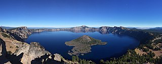
Crater Lake National Park is an American national park located in southern Oregon. Established in 1902, Crater Lake is the fifth-oldest national park in the United States and the only national park in Oregon. The park encompasses the caldera of Crater Lake, a remnant of Mount Mazama, a destroyed volcano, and the surrounding hills and forests.

Mount Adams, known by some Native American tribes as Pahto or Klickitat, is a potentially active stratovolcano in the Cascade Range. Although Adams has not erupted in more than 1,000 years, it is not considered extinct. It is the second-highest mountain in Washington, after Mount Rainier.
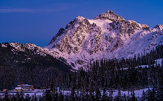
Mount Shuksan is a glaciated massif in the North Cascades National Park. Shuksan rises in Whatcom County, Washington immediately to the east of Mount Baker, and 11.6 miles (18.7 km) south of the Canada–US border. The mountain's name Shuksan is derived from the Lummi word [šéqsən], said to mean "high peak". The highest point on the mountain is a three-sided peak known as Summit Pyramid.

The Nooksack River is a river in western Whatcom County of the northwestern U.S. state of Washington, draining extensive valley systems within the North Cascades around Mount Shuksan, Mount Baker and the Twin Sisters, and a portion of Fraser Lowland south of the Canada–United States border.

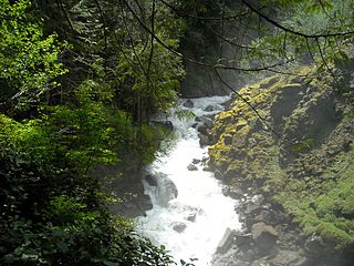
Nooksack Falls is a waterfall along the North Fork of the Nooksack River in Whatcom County, Washington. The water flows through a narrow valley and drops freely 88 feet into a deep rocky river canyon. The falls are viewable from the forested cover near the cliffs edge. The falls are a short 2/3 of a mile drive off the Mount Baker Highway, Washington. The falls were featured in the hunting scene of the movie The Deer Hunter.

Barr Creek Falls, is a waterfall located in the Rogue River Canyon within the Prospect State Scenic Viewpoint in Jackson County, in the U.S. state of Oregon. The waterfall is located at the south end of Barr Creek as it plunges into the Rogue River over a carved cliff surrounded by walls of petrified volcanic ash as a consequence of the Mount Mazama eruption. The waterfall has also been called Bear Creek Falls. The waterfall gets its name from the creek which was called "Barr" for the presence of a fence that prevented cattle from straying out of the local Red Blanket Ranch and that ran adjacent to the creek.

Bhandardara is a holiday resort village near Igatpuri, in the western ghats of India. The village is located in the Akole tehsil, Ahmednagar district of the state of Maharashtra, about 185 kilometers (115 mi) from Mumbai and 155 kilometers (96 mi) from Ahmednagar.

The Great Smoky Mountains National Park is a United States National Park located in a region of the Appalachian Mountains referred to as the Great Smoky Mountains, in a portion of east-central Tennessee and southwest North Carolina. With over 150 hiking trails extending for more than 850 miles (1,370 km), within its boundaries, including a seventy-mile segment of the Appalachian Trail, hiking is the most popular activity in the national park.

Mill Creek Falls, is a waterfall located in the Rogue River Canyon within the Prospect State Scenic Viewpoint in Jackson County, in the U.S. state of Oregon. The waterfall is located at the south end of Mill Creek as it plunges into the Rogue River over a carved cliff surrounded by walls of petrified volcanic ash consequence of Mount Mazama eruption.

Cayoosh Creek is a northeast-flowing tributary of the Seton River in the Canadian province of British Columbia. The name Cayoosh Creek remains on the bridge-sign crossing the stream on BC Highway 99 and continues in use locally to refer to the final reaches of the Seton River, formerly Seton Creek, which prior to the renaming ending at the confluence with Cayoosh Creek. The creek is the namesake of Cayoosh Creek Indian Reserve No. 1, one of the main Indian reserves of the Cayoose Creek Indian Band, which lies adjacent to what was renamed the Seton River without local consultation.
Blum Basin Falls is a waterfall in Whatcom County, in the U.S. state of Washington. It is located in North Cascades National Park on the headwaters of Blum Creek, a tributary of the Baker River. Fed by two small retreating glaciers and several snowfields on the southern side of Mount Blum, the waterfall is formed by the largest meltwater stream that feeds the mainstem of Blum Creek. The falls tumble 1,680 feet (510 m) down a high glacial headwall several miles within the national park in two distinct stages; the first is a series of slides over rounded rock, above the tree line, and the second is a series of near-vertical plunges to the forested valley below. Although most of the falls is clearly visible, parts of it are obscured by tall pines that grow at its base. There is no trail leading to the waterfall.
Wells Creek is a swift creek in Whatcom County, Washington. It is a tributary of the Nooksack River, joining the river just below Nooksack Falls. It is best known for having six major waterfalls along its course. Wells Creek was named for Hamilton C. Wells who prospected the area in the 1880s and 1890s.
Mazama Falls, also referred to more simply as Wells Creek Falls, is a waterfall on Wells Creek in the U.S. state of Washington. At nearly 500 feet (150 m) high, it is said to be the largest waterfall in the Wells Creek watershed.
The valley of the West Fork Foss River contains a fair amount of waterfalls. The river heads in a series of large lakes: Big Heart Lake, Angeline Lake, and Otter Lake- which form spectacular waterfalls as they plunge down to Delta Lake. On the valley walls downstream of Delta Lake, are found even more waterfalls.

Havasu Creek is a stream in the U.S. state of Arizona associated with the Havasupai people. It is a tributary to the Colorado River, which it enters in the Grand Canyon.

Wells Gray Provincial Park is a large wilderness park located in east-central British Columbia, Canada. The park protects most of the southern, and highest, regions of the Cariboo Mountains and covers 5,415 square kilometres. It is British Columbia's fifth largest provincial park, after Tweedsmuir, Tatshenshini, Spatsizi and Northern Rocky Mountains.

The Mount Adams Recreation Area is a 21,000-acre (8,500 ha) recreation area in the U.S. state of Washington managed by the Yakama Nation Tribal Forestry Program. The area encompasses an ecologically complex and geologically active landscape. The region features the most rugged side of Mount Adams, including canyons and the Great Gap section of the Mount Adams circumnavigation route, a three-mile trail-less section over two great canyons and many difficult glacial creeks. At 12,276 feet (3,742 m), Mount Adams is one of the major Cascade mountains. The recreation area is on the east side of the mountain and is part of the Yakama Indian Reservation and includes the popular Bird Creek Meadows area.

Mazama was a small steamboat driven by twin propellers that operated on upper Klamath Lake starting in 1909. Mazama was, reportedly, the only craft ever to navigate the Wood River, a tributary of upper Klamath Lake. For a few years, until the construction of a rail line, Mazama was an important link in transportation system linking Fort Klamath to Klamath Falls.

