
Oxfordshire is a ceremonial county in South East England. The county is bordered by Northamptonshire and Warwickshire to the north, Buckinghamshire to the east, Berkshire to the south, and Wiltshire and Gloucestershire to the west. The city of Oxford is the largest settlement and county town.

Henley-on-Thames is a town and civil parish on the River Thames in Oxfordshire, England, 9 miles (14 km) northeast of Reading, 7 miles (11 km) west of Maidenhead, 23 miles (37 km) southeast of Oxford and 37 miles (60 km) west of London, near the tripoint of Oxfordshire, Berkshire and Buckinghamshire. The population at the 2021 Census was 12,186.

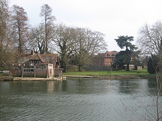
Greys Court is a Tudor country house and gardens in the southern Chiltern Hills at Rotherfield Greys, near Henley-on-Thames in the county of Oxfordshire, England. Now owned by the National Trust, it is located at grid reference SU725834, and is open to the public.
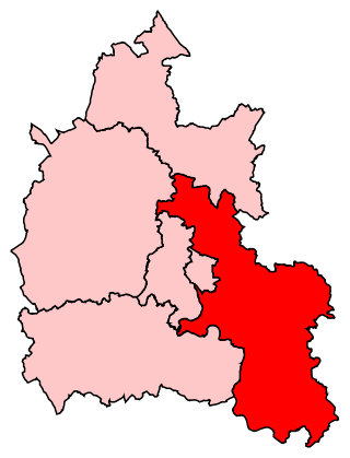
Henley is a constituency in Oxfordshire represented in the House of Commons of the UK Parliament since 2008 by John Howell, a Member of Parliament from the Conservative Party.

Nettlebed is a village and civil parish in Oxfordshire in the Chiltern Hills about 4+1⁄2 miles (7 km) northwest of Henley-on-Thames and 6 miles (10 km) southeast of Wallingford. The parish includes the hamlet of Crocker End, about 1⁄2 mile (800 m) east of the village. The 2011 Census recorded a parish population of 727.

Pishill is a village and former civil parish, now in the parish of Pishill with Stonor, in the South Oxfordshire district, in the county of Oxfordshire, England. It is about 5 miles (8 km) north of Henley-on-Thames, in the Stonor valley in the Chiltern Hills about 430 feet (130 m) above sea level. In 1921 the parish had a population of 147.

Rotherfield Greys is a village and civil parish in the Chiltern Hills in South Oxfordshire. It is 2 miles (3 km) west of Henley-on-Thames and just over 1 mile (1.6 km) east of Rotherfield Peppard. It is linked by a near-straight minor road to Henley.

Rotherfield Peppard is a village and civil parish in the Chiltern Hills in South Oxfordshire. It is centred 3 miles (5 km) west of Henley-on-Thames, 4+1⁄2 miles (7 km) north of Reading, Berkshire and 1 mile (1.6 km) southwest of Rotherfield Greys. The 2011 Census recorded the parish population as 1,649. The area includes Peppard Hill, which is 1⁄2 mile (800 m) west of the centre of the village and adjoins Sonning Common. Peppard Common is public woodland and meadow in between in a ravine. The far east of the parish is a golf course and the far west is Kingwood Common which is also wooded common land. In 1951, Elizabeth Goudge (1900–1984), novelist and winner of the Newberry Award for Best Children's Book, moved to Rotherfield Peppard, where she lived until her death. A blue plaque, unveiled in 2008, identifies her home.

Bix is a village in the civil parish of Bix and Assendon in South Oxfordshire, about 2.5 miles (4 km) northwest of Henley-on-Thames. The village is about 130 metres (430 ft) above sea level in the Chiltern Hills.

North Stoke is a small village beside the River Thames in the civil parish of Crowmarsh, in the South Oxfordshire district, in the county of Oxfordshire, England, 2 miles (3.2 km) south of the market town of Wallingford. Its 'Church of St Mary' is a Grade I listed building. In 1931 the parish had a population of 190. On 1 April 1932 the parish was abolished to form Crowmarsh.
Mongewell is a village in the civil parish of Crowmarsh in the South Oxfordshire district, in Oxfordshire, England, about 1 mile (1.6 km) south of Wallingford. Mongewell is on the east bank of the Thames, linked with the west bank at Winterbrook by Winterbrook Bridge. The earthwork Grim's Ditch, now part of The Ridgeway long-distance footpath, passes through the northern part of it and is a scheduled ancient monument. It has a church called St John the Baptist's Church.

Harpsden is a rural and semi-rural village and civil parish immediately south of Henley-on-Thames in South Oxfordshire, Oxfordshire, England. Its scattered centre is set 0.5 miles (0.80 km) from the east border which is the River Thames, marking a short boundary with Berkshire. The parish extends 5 miles (8.0 km) inland and borders Rotherfield Peppard to the west, that is, next to its main sections of woodland in the southern extreme of the Chiltern Hills including an SSSI area of ancient woodland. The village has neither a railway station nor shops, but has the main road from Reading to Henley, both of which have grown substantially since World War II into centres of trade, education and general meeting places, such as by their increased number of cafés and restaurants.

Burcot is a hamlet in the civil parish of Clifton Hampden, in the South Oxfordshire district, in the county of Oxfordshire, England. It is on the left bank of the River Thames. In 1931 the parish had a population of 187.

Admiral of the Fleet Richard James Meade, 4th Earl of Clanwilliam, styled Lord Gillford until 1879, was a Royal Navy officer. As a junior officer, he served at the Battle of Escape Creek and at the Battle of Fatshan Creek during the campaign against Chinese pirates. He also took part in the Battle of Canton, where he was severely wounded, during the Second Opium War.

Stonor is a mostly cultivated and wooded village and former civil parish, now in the parish of Pishill with Stonor, in the South Oxfordshire, district, in the county of Oxfordshire, England. It takes up part of the Stonor valley in the Chiltern Hills which rises to 120 meters above sea level within this south-east part of the civil parish, it is centred 3.8 miles (6.1 km) north of Henley-on-Thames. Stonor House close to the village centre has been the home of the Stonor family for more than eight centuries. The house and park are open to the public at certain times of the year. The house has a 12th-century private chapel built of flint and stone, with an early brick tower. There are also signs of a prehistoric stone circle in the park, which gives the place name its etymology.

Grafton is a hamlet and former civil parish, now in the parish of Grafton and Radcot, in the West Oxfordshire district, in the county of Oxfordshire, England. It is in the Thames Valley, about 3+1⁄2 miles (5.6 km) north of Faringdon. Grafton Lock is on the River Thames about 1 mile (1.6 km) south of the hamlet. In 1931 the parish had a population of 54.
Highmoor is a village and civil parish in the Chiltern Hills in Oxfordshire, about 4 miles (6.4 km) west of Henley-on-Thames. The parish includes the hamlet of Satwell. The Grade II Listed Church of England parish church of Saint Paul at Highmoor Cross was designed by the architect Joseph Morris of Reading and built by Robert Owthwaite of Henley-on-Thames in 1859 as a chapel of ease by the vicar of Rotherfield Peppard to cater for the wider rural population of the parish. Highmoor later became a separate parish but the church was closed by a pastoral order in June 2012 as a result of a dwindling congregation. The church was then put up for sale by the Diocese of Oxford.

Nether Worton is a hamlet in the civil parish of Worton, in the West Oxfordshire district, in the county of Oxfordshire, England. It is about 6+1⁄2 miles (10.5 km) south of Banbury and 7 miles (11 km) east of Chipping Norton. In 1931 the parish had a population of 42. On 1 April 1932 the parish was abolished and merged with Over Worton to form "Worton".
Vera Naomi Smith, also known as Vera Paul, was an English botanist and naturalist. She is noted for her discovery of the ghost orchid in 1931. In 1980, Paul received an OBE for her services to conservation.

