Badger Creek (Houston County, Minnesota)

Last updated

Badger Creek
USA Minnesota relief location map.svg
Red pog.svg
Mouth of Badger Creek
Location
Country United States
State Minnesota
County Houston County
Physical characteristics
Source 
  coordinates 43°39′37″N91°30′43″W / 43.6602778°N 91.5119444°W / 43.6602778; -91.5119444
Mouth  
  coordinates
43°44′15″N91°33′19″W / 43.7374667°N 91.5551426°W / 43.7374667; -91.5551426
Basin features
River system South Fork Root River
Tributaries 
  rightSwede Bottom Creek

Badger Creek is a stream in Houston County, in the U.S. state of Minnesota. It is a tributary of the South Fork Root River, which it meets east of Houston, Minnesota. [1] Badger Creek was named for the badgers once common in the area. [2]

Contents

Habitat

According to the Minnesota Department of Natural Resources, the following fish species are present in Badger Creek: Brown trout, brook trout, white sucker, creek chub, southern redbelly dace, northern redbelly dace, blacknose dace, longnose dace, bluntnose minnow, fathead minnow, common shiner, bigmouth shiner, central stoneroller, black bullhead, burbot, green sunfish, orange spotted sunfish, Johnny darter, fantail darter, central mudminnow, and brook stickleback. Habitat improvement was completed in 1970 in the upper reaches of the Badger Crek. [3]

See also

Related Research Articles

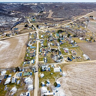
Grey Eagle Township is a township in Todd County, Minnesota, United States. The population was 663 according to a 2000 census and was 556 at the time of the 2020 Census.

<span class="mw-page-title-main">Cold Lake Provincial Park</span> Provincial park in Alberta, Canada

Cold Lake Provincial Park is a provincial park in northeastern Alberta, Canada.

<span class="mw-page-title-main">Fauna of West Virginia</span> Native animals of West Virginia

The life zones of West Virginia allow for a diversity of habitats for fauna, varying from large lowland farming valleys bordered with forest and meadow to highland ridge flats and heavy forestland, some with rocky ridge-line peaks. The "Mountain State" harbors at least 56 species and subspecies of mammals. The state has more than 300 types of birds and more than 100 species of fish.

<span class="mw-page-title-main">Medomak River</span> River in the United States

The Medomak River, historically known as the Muscongus River, is a 40-mile-long (64 km) river in Maine. From its source in Liberty, the river winds 32 miles (51 km) south to the head of its tidal river estuary in Waldoboro, then about 8 miles (13 km) south to Bremen. The river flows through Hockomock Channel into the head of Muscongus Bay. Medomak is Abenaki for "place (river) of many alewives".

<span class="mw-page-title-main">Money Creek (Root River tributary)</span> River in Minnesota, United States

Money Creek is a stream in Houston and Winona counties, in the U.S. state of Minnesota. It is a tributary of the Root River. Money Creek was so named when a passerby's money blew into the creek and was lost.

Rush Creek is a stream in Fillmore and Winona counties, in the U.S. state of Minnesota. It is a tributary of the Root River, which it joins in Rushford, Minnesota.

Camp Creek is a stream in Fillmore County, in the U.S. state of Minnesota. It is a tributary of the South Branch Root River. Camp Creek was named from the fact pioneer settlers camped upon its banks.

<span class="mw-page-title-main">Crooked Creek (Houston County, Minnesota)</span> River in Minnesota, United States

Crooked Creek is a stream in Houston County, in the U.S. state of Minnesota. Crooked Creek was so named on account of its irregular course.

<span class="mw-page-title-main">Raven River</span> River in Alberta, Canada

The Raven River or South Raven River is a major tributary of the Red Deer River located in Central-Western Alberta, Canada. The river is located in both the Clearwater County and Red Deer County.

<span class="mw-page-title-main">Detroit Lake (Minnesota)</span> Lake in Minnesota

Detroit Lake is a lake, locally known as Big Detroit and Little Detroit, has two distinct basins that are separated by a shallow gravel bar. At 3,067 acres, Detroit Lake is the largest lake within the Pelican River Watershed District and lies entirely within the city of Detroit Lakes, Minnesota municipal boundaries.

References

  1. U.S. Geological Survey Geographic Names Information System: Badger Creek
  2. Upham, Warren (1920). Minnesota Geographic Names: Their Origin and Historic Significance. Minnesota Historical Society. p.  241.
  3. "Houston County". Minnesota DNR. Retrieved March 25, 2021.