Pine Creek (Rush Creek tributary)

Last updated
Pine Creek
Pine Creek.jpg
Section of Pine Creek
Winona Trout Streams.jpg
main section of Pine Creek showing tributaries
USA Minnesota relief location map.svg
Red pog.svg
Mouth of Pine Creek
Location
Countries United States
StatesMinnesota
Counties Winona, Fillmore
Physical characteristics
Source 
  location St. Charles Township, Winona County, Minnesota
  coordinates 43°56′40″N91°54′18″W / 43.944427925898594°N 91.9049168509712°W / 43.944427925898594; -91.9049168509712
Mouth Rush Creek
  location
Rushford, Minnesota
  coordinates
43°50′52″N91°47′52″W / 43.8477416°N 91.7976499°W / 43.8477416; -91.7976499 Coordinates: 43°50′52″N91°47′52″W / 43.8477416°N 91.7976499°W / 43.8477416; -91.7976499
Basin features
River system Root River
Tributaries 
  leftHemminingway Creek, Coolrdige Creek
BridgesSchool Section Road and Rt. 25 bridges

Pine Creek is a stream in Fillmore and Winona counties, in the U.S. state of Minnesota. [1] It is a tributary of the Rush Creek, which is a tributary of the Root River. It joins the Rush Creek in the extreme north of Rushford, Minnesota. Tributaries of Pine Creek are Cooledge Creek and Hemmingway Creek. [2] [1]

Contents

Habitat

Pine Creek meanders through rural farmland in southern Winona and northern Filmore Counties. According to the Minnesota Department of Natural resources, the species of fish present include brown trout, brook trout, white sucker, northern hog sucker, creek chub, longnose dace, blacknose dace, fantail darter, slimy sculpin, mottled sculpin, and brook stickleback. [3] [4]

Rush Creek suffered severe flooding in the Southeast Minnesota floods of August 1820, 2007. [5] The fish habitat and floodplain in sections of Pine Creek were restored in 2015 by the Minnesota Trout Unlimited. [6] [7] [8]

Extents

The Pine Creek source is located in St. Charles Township, just below Interstate 90. It meanders south to Fillmore County before heading north where it runs east in Winona County along Winona County Road 2 and meets up with the Rush Creek in Winona County north of Rushford, Minnesota. [1]

A bridge was built over Pine Creek on School Section Road in 2002. [9]

Note: There are two Pine Creeks in Winona County. This Pine Creek is west of State Highway 43. It is sometimes called Fillmore County Pine Creek.The other Pine Creek (Mississippi River tributary) is in the east end of Winona County and Houston County. [7]

Tributaries

Coolridge Creek, Winona County, Minnesota Coolridge Creek.jpg
Coolridge Creek, Winona County, Minnesota

There are two small tributaries of Pine Creek, Coolridge Creek with a length of 1.23 miles and Hemingway Creek with a length of 2.19 miles. Brown trout, brook trout, creek chub, blacknose dace, longnose dace, central stoneroller, slimy sculpin, white sucker, and brook stickleback are present in both tributaries. The Minnesota Department of Natural Resources conducted a study using Coolridge and Hemingway Creeks to investigate the effects of brown trout on native brook trout. Brown trout were kept out of Coolridge Creek and the natural migration of brown trout from Pine Creek to Hemingway Creek was allowed to continue during the experiment. An increase in growth rate and survival was noted in Coolridge Creek but the mature size of the brook trout was not appreciably different from the Hemingway Creek where brown trout were allowed. [10] [11] [12]

Related Research Articles

Root River (Minnesota)

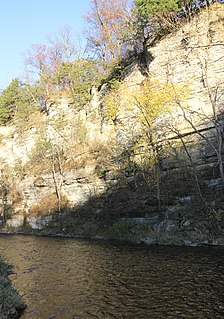
The Root River flows for 80 miles (130 km) through the Driftless Area of southeastern Minnesota and is a tributary of the Upper Mississippi River. The Root River is formed by three branches, the North, South and Middle branches of the Root River and the South Fork Root River. It is an excellent river for canoeing and fishing. The gentle to moderate flowing river drops an average of 3.4 ft/mile from Chatfield, Minnesota, to its pour point in the Mississippi River into Navigation Pool 7 just south of La Crosse, Wisconsin and east of Hokah, Minnesota.

Cold Lake Provincial Park

Cold Lake Provincial Park is a provincial park in north eastern Alberta, Canada.

Slate Run

Slate Run is a 7.3-mile-long (11.7 km) tributary of Pine Creek in Tioga and Lycoming counties, Pennsylvania in the United States.

Blacktail Deer Creek

Blacktail Deer Creek is a tributary of the Beaverhead River, approximately 38 miles (61 km) long, in southwest Montana, United States.

Money Creek (Root River tributary)

Money Creek is a stream in Houston and Winona counties, in the U.S. state of Minnesota. It is a tributary of the Root River. Money Creek was so named when a passerby's money blew into the creek and was lost.

Rush Creek is a stream in Fillmore and Winona counties, in the U.S. state of Minnesota. It is a tributary of the Root River, which it joins in Rushford, Minnesota.

Camp Creek (Root River tributary)

Camp Creek is a stream in Fillmore County, in the U.S. state of Minnesota. It is a tributary of the South Branch Root River. Camp Creek was named from the fact pioneer settlers camped upon its banks.

Crooked Creek (Houston County, Minnesota)

Crooked Creek is a stream in Houston County, in the U.S. state of Minnesota. Crooked Creek was so named on account of its irregular course.

Badger Creek (Houston County, Minnesota) Creek in Houston County, Minnesota, USA


Badger Creek is a stream in Houston County, in the U.S. state of Minnesota. It is a tributary of the South Fork Root River, which it meets east of Houston, Minnesota. Badger Creek was named for the badgers once common in the area.

Raven River

The Raven River or South Raven River is a major tributary of the Red Deer River located in Central-Western Alberta, Canada. The river is located in both the Clearwater County and Red Deer County.

North Raven River

The North Raven River or Stauffer Creek is a major tributary of the Raven River located in western Central Alberta, Canada. It is located in the Red Deer River system. The river is a popular place for anglers.

References

  1. 1 2 3 U.S. Geological Survey Geographic Names Information System: Pine Creek (Rush Creek tributary)
  2. "Trout Streams of Southeast Minnesota". Minnesota DNR. Retrieved March 23, 2021.
  3. "Winona County". Minnesota DNR. Retrieved March 23, 2021.
  4. "Pine Creek". DNR. Retrieved April 10, 2021.
  5. "44 photos: A look back at deadly 2007 flooding in the La Crosse and Winona areas". LaCross Tribune. Retrieved March 21, 2021.
  6. "Fish habitat and floodplain restoration of a Minnesota trout stream". Barr Engineering. Retrieved March 18, 2021.
  7. 1 2 Reisetter, Mark. "Fishing Pine Creek". Minnesota Trout Unlimited. Retrieved March 23, 2021.
  8. "Pine Creek Easements" (PDF). National Trout Center. Retrieved March 23, 2021.
  9. "SCHOOL SECTION RD over Pine Creek". Bridge Reports. Retrieved March 23, 2021.
  10. "Southeast Minnesota Map Number 5" (PDF). Minnesota Department of Natural Resources . 2011. Retrieved March 29, 2021.
  11. Hoxmeier, John; Dieterman, Douglas (October 1, 2016). "Long-term population of native brook trout following manipulative reduction of an invader". Biological Invasions. 18. Retrieved March 31, 2021.
  12. "Brook Trout History, Natural History and the Genetics of Minnesota's Native Trout in SE MN" (PDF). Minnesota Trout Unlimited Newsletter. Retrieved April 2, 2021.