
Dymock is a village and civil parish in the Forest of Dean district of Gloucestershire, England, about four miles south of Ledbury. In 2014 the parish had an estimated population of 1,205.

Patchway is a town and civil parish in South Gloucestershire, England, situated 6 mi (9.7 km) north-north west of central Bristol. The town has become an overflow settlement for Bristol and is contiguous with Bristol's urban area, along with the nearby towns of Filton and Bradley Stoke.
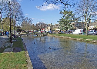
Bourton-on-the-Water is a village and civil parish in Gloucestershire, England, that lies on a wide flat vale within the Cotswolds Area of Outstanding Natural Beauty. The village had a population of 3,296 at the 2011 census. Much of the village centre is a designated Conservation Area.

Churchdown is a large village in Gloucestershire, England, situated between Gloucester and Cheltenham in the south of the Tewkesbury Borough.
Westerleigh is a clustered village in the civil parish of Westerleigh and Coalpit Heath in the South Gloucestershire district, in the ceremonial county of Gloucestershire, England, it contains sources of the Frome and has an endpoint of the Frome Valley Walkway. It is 0.8 miles (1.3 km) north of the M4, 1 mile (1.6 km) south of Yate and 10 miles (16 km) north-east of the city of Bristol. In the south it includes a steep hill of its own 5 miles (8.0 km) from the crest of the Cotswold hills which is designated an AONB.
Kemble is a village in the civil parish of Kemble and Ewen, in the Cotswold district of Gloucestershire, England. Historically part of Wiltshire, it lies 4 miles (6.4 km) from Cirencester and is the settlement closest to Thames Head, the source of the River Thames. In 2020 it had an estimated population of 940. At the 2011 census the parish had a population of 1,036.
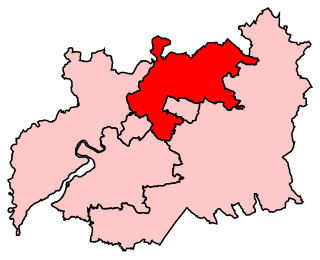
Tewkesbury is a constituency in Gloucestershire represented in the House of Commons of the UK Parliament since 2024 by Cameron Thomas, a Liberal Democrat.

Frampton on Severn is a village and civil parish in Gloucestershire, England. The population is 1,432.

Newnham or Newnham on Severn is a village in west Gloucestershire, England. It lies in the Royal Forest of Dean, on the west bank of the River Severn, approximately 10 miles south-west of Gloucester and three miles southeast of Cinderford. It is on the A48 road between Gloucester and Chepstow, Monmouthshire, Wales. The village has a parish council.

Hardwicke is a large village on the A38 road 7 km south of the city of Gloucester, Gloucestershire, England. Despite its proximity to Gloucester, the village comes under Stroud Council. The population of the village taken at the United Kingdom Census 2011 was 3,901.

Acton Turville is a parish in the Cotswold Edge ward within South Gloucestershire, England. It lies 17 miles (27 km) east-northeast of Bristol. The M4 is south of the parish. Acton Turville consists of a cluster of households across 1,009 acres, with a total population of 370 people. Acton Turville is also listed as "Achetone" in the Domesday Book.

Aldsworth is a village and civil parish in the Cotswold district of Gloucestershire, about ten miles north-east of Cirencester. In 2010 its population was 236. Aldsworth is a large parish, slightly north of the River Leach, located in the South West of the United Kingdom.

Quedgeley is a town and civil parish in the city of Gloucester district in Gloucestershire, England. A thin strip of land between the Severn and the Gloucester Ship Canal occupies the west, and the south-eastern part of the town is Kingsway Village, directly to the north of which is Tuffley.

Awre is a village, civil parish and electoral ward in the Forest of Dean District of Gloucestershire, England, near the River Severn.

Broadwell is a village and civil parish in the English county of Gloucestershire. It is about 1.5 miles (2.4 km) north of Stow-on-the-Wold, In the 2001 United Kingdom census, the parish had a population of 384. decreasing to 355 at the 2011 census.

Mitcheldean is a market town in the Forest of Dean in Gloucestershire, England.

Longhope is a village in west Gloucestershire, situated within the Forest of Dean, England, United Kingdom. Arthur Bullock, who was born in Longhope in 1899, described its location as follows: The parish occupies the most easterly valley in the group of hills which lie between the Severn and the Wye. The name means long valley. It is about four miles long, running roughly north to south, and it is separated from the Severn valley by a range of hills consisting of May Hill (937 ft), Huntley Hill, Blaisdon Hill and Notwood Hill.'

Highnam is a village and civil parish on the outskirts of the city of Gloucester. It is three miles northwest of the city on the A40, on the way to Ross, west of Alney Island and Over Bridge. It is connected by Segregated Bicycle Paths via Over Bridge and Alney Island to Gloucester. The parish includes the villages of Lassington and Over. In the 2001 census the parish had a population of 2,014, reducing to 1,916 at the 2011 census. At the 2021 census it had increased to 2,141.

Upton St Leonards is a village in the English county of Gloucestershire. Forming part of the district of Stroud, it is a mile or so north of the A46 road between Stroud and Cheltenham.

Norton is a settlement and civil parish in the English county of Gloucestershire.
 Holy Trinity Church
 House viewed from the Gloucestershire Way which crosses its driveway
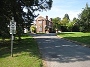 Badgeworth Court, in the Dutch Colonial style (1829), former home of Colonel Selwyn Payne


