New Carlisle, Quebec is a town in the Gaspésie–Îles-de-la-Madeleine region of Quebec, Canada, best known as the boyhood home of René Lévesque; although he was born at Campbellton, New Brunswick. The population is approximately 1,388, half English-speaking and half French-speaking. New Carlisle is located on the Baie des Chaleurs.

Baie-Saint-Paul is a city in the Province of Quebec, Canada, on the northern shore of the Saint Lawrence River. Baie-Saint-Paul is the seat of Charlevoix Regional County Municipality. The city is situated at the mouth of the Gouffre River. It is known for its art galleries, shops and restaurants.
Baie-Comeau is a city located approximately 420 kilometres (260 mi) north-east of Quebec City in the Côte-Nord region of the province of Quebec, Canada. It is located on the shores of the Saint Lawrence River near the mouth of the Manicouagan River, and is the seat of Manicouagan Regional County Municipality.

Manicouagan is a regional county municipality in the Côte-Nord region of Quebec, Canada. It is located on the north shore of the Saint Lawrence River with its seat in Baie-Comeau. It was created in 1981, and named after the Manicouagan River.
The Town of Île-Perrot is a town and municipality on Île Perrot in southwestern Quebec, Canada. The population as of the Canada 2011 Census was 10,503. The town is at the western end of Lake Saint-Louis, and borders the local island communities of Terrasse-Vaudreuil, Pincourt and Notre-Dame-de-l'Île-Perrot. It also includes Dowker Island and the small Claude and Bellevue Islands.

Bonaventure is a town on the Gaspé Peninsula in the Bonaventure Regional County Municipality of Quebec. It is located on Baie des Chaleurs near the mouth of the Bonaventure River. The town is situated on Route 132 between Saint-Siméon and New Carlisle.

The Municipality of Baie-James was a municipality in northern Quebec, Canada, which existed from 1971 to 2012. Located to the east of James Bay, Baie-James covered 297,332.84 km2 (114,800.85 sq mi) of land, making it the largest incorporated municipality in Canada — only eight unorganized territories were larger. Its territory almost entirely covered the administrative region of Jamésie, although it contained less than five percent of the population. Essentially, it was the remainder of the Jamésie Territory's land after all of the major population centres were removed.

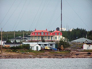
The Municipality of Gros-Mécatina is on the Lower North Shore of the Gulf of Saint Lawrence, near the border with Labrador in Quebec, Canada. Located near crab, lobster, and scallop fishing grounds, it is dependent on the fishing business, including a fish processing factory that contributes to regional economic activity.

Blanc-Sablon is the easternmost community in Le Golfe-du-Saint-Laurent Regional County Municipality, in the administrative région of Côte-Nord, in the province of Quebec, Canada. With a population of 1,118 inhabitants, it is the most populous community in the county municipality.

Baie-du-Febvre is a municipality in the Nicolet-Yamaska Regional County Municipality of Quebec, Canada. The population as of the Canada 2011 Census was 1,010. The municipality lies on the south shore of Lac Saint-Pierre, a section of the Saint Lawrence River.

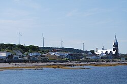
Paspébiac is a city on Baie des Chaleurs in the Gaspésie region of eastern Quebec, Canada. The population was 3,198 as of the Canada 2011 Census. The town is noted for the Banc de Pêche de Paspébiac, a large sandbar jutting out into the bay which has been designated a National Historic Site of Canada.

Notre-Dame-de-l'Île-Perrot is the largest of four municipalities located on Île Perrot, west of the island of Montreal, Quebec. The population as of the Canada 2016 Census was 10,654. It hosts the island's first church built in 1740 originally situated at Pointe-du-Moulin which was reconstituted as the Chapelle du Souvenir in 1953 beside the church of Sainte-Jeanne-de-Chantal across from the town hall.

Lac-des-Plages is a town and municipality in the Outaouais region of Quebec, Canada, part of the Papineau Regional County Municipality. It is named after Lac des Plages which attracts many vacationers with the beauty of its beaches.

Saint-Anicet is a municipality in Le Haut-Saint-Laurent Regional County Municipality in the Montérégie administrative region of Quebec. The population as of the Canada 2011 Census was 2,523.
Saint-Stanislas-de-Kostka is a municipality of Quebec, Canada, located within the Beauharnois-Salaberry Regional County Municipality in the Montérégie administrative region. The population as of the Canada 2011 Census was 1,553.
Baie-Johan-Beetz is a municipality and village in the Côte-Nord region of the province of Quebec in Canada, located some 60 kilometres (37 mi) east of Havre-Saint-Pierre. It has the lowest population of all incorporated places in the Côte-Nord region.

Baie-des-Chaloupes is an unorganized territory of Quebec located in the regional county municipality of Antoine-Labelle, in Laurentides, in Québec, in Canada. It covers a land area of 900 km.

Sainte-Paule is a municipality in Quebec, Canada.

Saint-Ulric is a municipality in Quebec, Canada.

Matane is a town on the Gaspé Peninsula in Quebec, Canada, on the south shore of the Saint Lawrence River at the mouth of the Matane River. The town is the seat for the La Matanie Regional County Municipality.