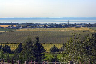
Grosses-Roches

Last updated

Grosses-Roches
Grosses-Roches.jpg
Grosses-Roches Quebec location diagram.png
Location within La Matanie RCM
Canada Eastern Quebec location map.png
Red pog.svg
Grosses-Roches
Location in eastern Quebec
Coordinates: 48°56′N67°10′W / 48.933°N 67.167°W / 48.933; -67.167 [1]
Country Canada
Province Quebec
Region Bas-Saint-Laurent
RCM La Matanie
Settledmid 19th century
ConstitutedAugust 19, 1939
Government
[2]
  MayorBruno Fournier
   Federal riding Haute-Gaspésie—La Mitis—Matane—Matapédia
   Prov. riding Matane-Matapédia
Area
  Total63.95 km2 (24.69 sq mi)
  Land63.59 km2 (24.55 sq mi)
Population
 (2021) [3]
  Total375
  Density5.9/km2 (15/sq mi)
  Pop (2016-21)
Decrease2.svg 4.8%
  Dwellings
261
Time zone UTC−5 (EST)
  Summer (DST) UTC−4 (EDT)
Postal code(s)
Area code(s) 418 and 581
HighwaysQc132.svg R-132
Website municipalite.grossesroches.ca OOjs UI icon edit-ltr-progressive.svg

Grosses-Roches is a municipality in Quebec, Canada.

Contents

History

Settlement began in the mid-19th century and the place was called Grosses-Roches (French for "big rocks"), referring to a large number of small, rounded, brownish rocks. In 1870, the parish of Saints-Sept-Frères was founded. In 1881, the post office opened. [1]

On August 19, 1939, the Municipality of Grosses-Roches was formed when it ceded from the Parish Municipality of Sainte-Félicité. [1] [4]

Demographics

In the 2021 Census of Population conducted by Statistics Canada, Grosses-Roches had a population of 375 living in 206 of its 261 total private dwellings, a change of -4.8% from its 2016 population of 394. With a land area of 63.59 km2 (24.55 sq mi), it had a population density of 5.9/km2 (15.3/sq mi) in 2021. [3]

Canada census – Grosses-Roches community profile
2021 2016 2011
Population375 (-4.8% from 2016)394 (-4.1% from 2011)411 (-1.2% from 2006)
Land area63.59 km2 (24.55 sq mi)64.00 km2 (24.71 sq mi)63.65 km2 (24.58 sq mi)
Population density5.9/km2 (15/sq mi)6.2/km2 (16/sq mi)6.5/km2 (17/sq mi)
Median age61.2 (M: 62.4, F: 58.8)59.1 (M: 59.9, F: 58.1)52.9 (M: 54.1, F: 51.7)
Private dwellings261 (total)  206 (occupied)280 (total)  209 (occupied)250 (total) 
Median household income$41,600$34,432$28,942
Notes: 2016 Data based on population and dwelling count amendments. [5]
References: 2021 [6] 2016 [7] 2011 [8] earlier [9] [10]
Historical Census Data - Grosses-Roches, Quebec
YearPop.±%
1941 807    
1951 886+9.8%
1956 904+2.0%
1961 804−11.1%
1966 697−13.3%
1971 639−8.3%
YearPop.±%
1976 599−6.3%
1981 561−6.3%
1986 580+3.4%
1991 517−10.9%
1996 493−4.6%
2001 457−7.3%
YearPop.±%
2006 416−9.0%
2011 411−1.2%
2016 394−4.1%
2021 375−4.8%
2016 Population based on revised count.
Source: Statistics Canada [11]

Government

List of former mayors:

See also

Related Research Articles

<span class="mw-page-title-main">Saint-Éloi, Quebec</span> Parish municipality in Quebec, Canada

Saint-Éloi is a parish municipality in the region of Bas-Saint-Laurent, Quebec, Canada. Its population was 310 in the Canada 2021 Census.

<span class="mw-page-title-main">Caniapiscau Regional County Municipality</span> Regional county municipality in Quebec, Canada

Caniapiscau is a regional county municipality in the Côte-Nord region of Quebec, Canada. The seat is Fermont.

<span class="mw-page-title-main">Melbourne, Quebec</span> Township municipality in Quebec, Canada

Melbourne is a township municipality located in Le Val-Saint-François Regional County Municipality in the Estrie region of Quebec, Canada.

<span class="mw-page-title-main">Métis-sur-Mer</span> City in Quebec, Canada

Métis-sur-Mer is a city in the La Mitis Regional County Municipality within the Bas-Saint-Laurent region of Quebec, Canada. It had a population of 594 in the Canada 2021 Census.

<span class="mw-page-title-main">Stratford, Quebec</span> Township municipality in Quebec, Canada

Stratford is a township municipality in Le Granit Regional County Municipality in the Estrie region in Quebec, Canada. A township municipality is all or part of the territory of a township set up as a municipality.

<span class="mw-page-title-main">Hampden, Quebec</span> Township municipality in Quebec, Canada

Hampden is a township municipality of about 200 people in Le Haut-Saint-François Regional County Municipality, in the Estrie region of Quebec, Canada.

<span class="mw-page-title-main">Saint-Barnabé, Quebec</span> Parish municipality in Quebec, Canada

Saint-Barnabé, also known as Saint-Barnabé-Nord, is a parish municipality in the Mauricie region of the province of Quebec in Canada.

<span class="mw-page-title-main">Laforce</span> Municipality in Quebec, Canada

Laforce is a municipality in northwestern Quebec, Canada, in the Témiscamingue Regional County Municipality.

<span class="mw-page-title-main">Moffet, Quebec</span> Municipality in Quebec, Canada

Moffet is a municipality in northwestern Quebec, Canada, in the Témiscamingue Regional County Municipality. The municipality had a population of 206 as of the 2021 Canadian census.
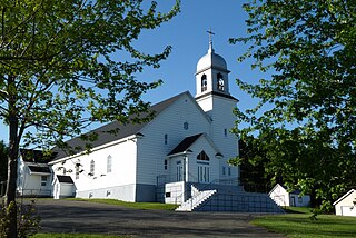
<span class="mw-page-title-main">La Trinité-des-Monts</span> Parish municipality in Quebec, Canada

La Trinité-des-Monts is a parish municipality in the Canadian province of Quebec, located in the Rimouski-Neigette Regional County Municipality.

<span class="mw-page-title-main">Saint-Adelme</span> Parish municipality in Quebec, Canada

Saint-Adelme is a parish municipality in the Canadian province of Quebec, located in La Matanie Regional County Municipality in the Bas-Saint-Laurent region.

<span class="mw-page-title-main">Saint-Jean-de-Cherbourg</span> Parish municipality in Quebec, Canada

Saint-Jean-de-Cherbourg is a parish municipality in the Canadian province of Quebec, located in La Matanie Regional County Municipality.

<span class="mw-page-title-main">Chichester, Quebec</span> Township municipality in Quebec, Canada

Chichester is a township municipality and village in the Canadian province of Quebec, located within the Pontiac Regional County Municipality.

<span class="mw-page-title-main">Sainte-Anne-du-Lac</span> Municipality in Quebec, Canada

Sainte-Anne-du-Lac is a municipality and village in the Laurentides region of Quebec, Canada, part of the Antoine-Labelle Regional County Municipality.

<span class="mw-page-title-main">Sacré-Coeur, Quebec</span> Municipality in Quebec, Canada

Sacré-Coeur is a municipality in the Côte-Nord region of the province of Quebec in Canada.

<span class="mw-page-title-main">Mont-Saint-Michel, Quebec</span> Municipality in Quebec, Canada

Mont-Saint-Michel is a municipality in the Laurentides region of Quebec, Canada, part of the Antoine-Labelle Regional County Municipality.

<span class="mw-page-title-main">Saint-René-de-Matane</span> Municipality in Quebec, Canada

Saint-René-de-Matane is a municipality in Quebec, Canada.

<span class="mw-page-title-main">Sainte-Françoise, Bas-Saint-Laurent</span> Parish municipality in Quebec, Canada

Sainte-Françoise is a parish municipality in the Bas-Saint-Laurent region of Quebec, Canada.

Lac-Vacher is an unorganized territory in the Côte-Nord region of Quebec, Canada, part of Caniapiscau Regional County Municipality.

<span class="mw-page-title-main">Kataskomiq</span> Indian reserve in Quebec, Canada

Kataskomiq is an Indian reserve listed by the Canadian Geographical Names Database. The reserve belongs to the Wolastoqiyik Wahsipekuk (Viger) First Nation, Maliseet people. It is not listed by Indigenous and Northern Affairs Canada or the last two Canadian census. It is located in the Bas-Saint-Laurent region of Quebec, geographically located within the territory of Rivière-du-Loup Regional County Municipality but is not legally part of it. Its population was 0 in the 2006 Canadian census and does not appear in either the 2011 or 2016 Canadian Census. Before 2021 it was known as Whitworth.

References

  1. 1 2 3 "Banque de noms de lieux du Québec: Reference number 27260". toponymie.gouv.qc.ca (in French). Commission de toponymie du Québec.
  2. 1 2 "Répertoire des municipalités: Geographic code 08015". www.mamh.gouv.qc.ca (in French). Ministère des Affaires municipales et de l'Habitation. Retrieved 2024-09-04.
  3. 1 2 3 "Grosses-Roches (Code 2408015) Census Profile". 2021 census . Government of Canada - Statistics Canada . Retrieved 2024-09-04.
  4. "Répertoire des entités géopolitiques: Grosses-Roches (municipalité) 19.8.1939 - ..." www.mairesduquebec.com. Institut généalogique Drouin. Retrieved 4 September 2024.
  5. "Population and dwelling count amendments, 2016 Census". www12.statcan.gc.ca. Government of Canada - Statistics Canada. Retrieved 4 September 2024.
  6. "2021 Community Profiles". 2021 Canadian census . Statistics Canada. February 4, 2022. Retrieved 2023-10-19.
  7. "2016 Community Profiles". 2016 Canadian census . Statistics Canada. August 12, 2021. Retrieved 2022-11-17.
  8. "2011 Community Profiles". 2011 Canadian census . Statistics Canada. March 21, 2019. Retrieved 2014-02-08.
  9. "2006 Community Profiles". 2006 Canadian census . Statistics Canada. August 20, 2019.
  10. "2001 Community Profiles". 2001 Canadian census . Statistics Canada. July 18, 2021.
  11. 1996, 2001, 2006, 2011, 2016 census