Saguenay is a city in the Saguenay–Lac-Saint-Jean region of Quebec, Canada, on the Saguenay River, about 200 kilometres (120 mi) north of Quebec City by overland route. It is about 126 kilometres (78 mi) upriver and northwest of Tadoussac, located at the confluence with the St. Lawrence River. It was formed in 2002 by merging the cities of Chicoutimi and Jonquière and the town of La Baie. Chicoutimi was founded by French colonists in 1676.

Lake Saint Pierre is a lake in Quebec, Canada, a widening of the Saint Lawrence River between Sorel-Tracy and Trois-Rivières. It is located downstream, and northeast, of Montreal; and upstream, and southwest, of Quebec City. The end of the lake delimits the beginning of the estuary of Saint Lawrence.

Antoine-Labelle is a regional county municipality located in the Laurentides region of Quebec, Canada. Its seat is Mont-Laurier. It is named for Antoine Labelle.

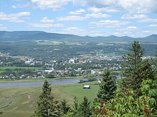
Baie-Saint-Paul is a city in the Province of Quebec, Canada, on the northern shore of the Saint Lawrence River. Baie-Saint-Paul is the seat of Charlevoix Regional County Municipality. The city is situated at the mouth of the Gouffre River. It is known for its art galleries, shops and restaurants.
Baie-Comeau is a city located approximately 420 km (260 mi) north-east of Quebec City in the Côte-Nord region of the province of Quebec, Canada. It is located on the shores of the Saint Lawrence River near the mouth of the Manicouagan River, and is the seat of Manicouagan Regional County Municipality.

Minganie is a regional county municipality in the Côte-Nord region of Quebec, Canada. It includes Anticosti Island. Its seat is Havre-Saint-Pierre.
Vaudreuil-Soulanges is a regional county municipality in Quebec, Canada. It is located on a triangular peninsula in the western Montérégie region of Quebec, formed by the confluence of the Ottawa River to the north, and the St. Lawrence River to the south. Ontario is located west of here.

The Municipality of Gros-Mécatina is on the Lower North Shore of the Gulf of Saint Lawrence, near the border with Labrador in Quebec, Canada. Located near crab, lobster, and scallop fishing grounds, it is dependent on the fishing business, including a fish processing factory that contributes to regional economic activity.

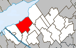
Nicolet, Quebec is the county seat of Nicolet-Yamaska Regional County Municipality, Quebec, Canada. The population as of the Canada 2011 Census was 7,828. It is the seat of the Roman Catholic Diocese of Nicolet.

Saint-Zotique is a municipality located within the Vaudreuil-Soulanges Regional County Municipality in the Montérégie region located about 45 minutes west of Montreal, Quebec, Canada. It is named for Saint Zoticus of Comana.

La Visitation-de-l'Île-Dupas is a municipality in the Lanaudière region of Quebec, Canada, part of the D'Autray Regional County Municipality. Its territory is located on several of the Sorel Islands in the Saint Lawrence River where it flows into Lac Saint-Pierre. The largest of these islands is Dupas Island, also known as Isle du Pads, Île d'Angoulème, and Île du Richelieu at various times in the past.

The Nicolet River is a river in Quebec, Canada. It is a tributary of the Saint Lawrence River on its southern shore and flows into Lake Saint Pierre. It is named in honor of the pioneer Jean Nicolet.
The Nicolet Bird sanctuary is a protected area in Quebec and one of the 28 migratory bird sanctuary of that province. This refuge protects a migratory halt for duck and Canada goose and also a nesting area for waterfowl. It is located a few kilometers west of Nicolet on the south shore of Lake Saint Pierre.
The Charlevoix Biosphere Reserve is part of the Man and the Biosphere Program of the UNESCO. It is managed by the Charlevoix Biosphere Reserve Corporation.
The Lévesque River is a tributary on the south shore of Lake Saint-Pierre which is crossed to the northeast by the St. Lawrence River. The Lévesque river crosses the municipalities of Saint-Elphège, Pierreville and Baie-du-Febvre, in the Nicolet-Yamaska Regional County Municipality (MRC), in the administrative region of Centre-du-Québec, in Quebec, in Canada.
The Colbert river is a tributary on the southeast shore of lake Saint-Pierre which is crossed to the northeast by the St. Lawrence River. The Colbert river crosses the municipalities of Saint-Elphège and Baie-du-Febvre, in the Nicolet-Yamaska Regional County Municipality (MRC), in the administrative region of Centre-du-Québec, in Quebec, in Canada.
The Landroche River is a tributary on the south shore of Lake Saint-Pierre which is crossed to the northeast by the St. Lawrence River. The Landroche river flows in the municipality of Baie-du-Febvre, in the Nicolet-Yamaska Regional County Municipality (MRC), in the administrative region of Centre-du-Quebec, in Quebec, in Canada.
The rivière des Frères is a tributary on the south shore of lake Saint-Pierre which is crossed to the northeast by the St. Lawrence River. The rivière des Frères flows in the municipality of Baie-du-Febvre, in the Nicolet-Yamaska Regional County Municipality (MRC), in the administrative region of Centre-du-Québec, in Québec, in Canada.
The Nicolet Southwest River is a tributary on the west bank of the Nicolet River. It empties into the municipality of Nicolet, in the Nicolet-Yamaska Regional County Municipality (MRC), in the administrative region of Centre-du-Québec, in Quebec, in Canada.