
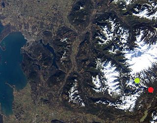
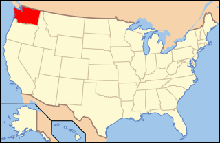
North Cascades National Park is an American national park in the state of Washington. At more than 500,000 acres (200,000 ha), North Cascades National Park is the largest of the three National Park Service units that comprise the North Cascades National Park Complex. North Cascades National Park consists of a northern and southern section, bisected by the Skagit River that flows through Ross Lake National Recreation Area. Lake Chelan National Recreation Area lies on the southern border of the south unit of the park. In addition to the two national recreation areas, other protected lands including several national forests and wilderness areas, as well as Canadian provincial parks in British Columbia, nearly surround the park. North Cascades National Park features the rugged mountain peaks of the North Cascades Range, the most expansive glacial system in the contiguous United States, the headwaters of numerous waterways, and vast forests with the highest degree of flora biodiversity of any American national park.

The White River is a white, glacial river in the U.S. state of Washington. It flows about 75 miles (121 km) from its source, the Emmons Glacier on Mount Rainier, to join the Puyallup River at Sumner. It defines part of the boundary between King and Pierce counties.

The Skagit River is a river in southwestern British Columbia in Canada and northwestern Washington in the United States, approximately 150 mi (240 km) long. The river and its tributaries drain an area of 1.7 million acres (690,000 hectares) of the Cascade Range along the northern end of Puget Sound and flows into the sound.

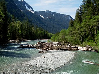
The Sauk River is a tributary of the Skagit River, approximately 45 miles (72 km) long, in northwestern Washington in the United States. It drains an area of the high Cascade Range in the watershed of Puget Sound north of Seattle. The river is a popular destination for fly fishing. It is a National Wild and Scenic River.

Ross Lake is a large reservoir in the North Cascade mountains of northern Washington state, United States, and southwestern British Columbia, Canada. The lake runs approximately north-south, is 23 miles (37 km) long, up to 1.5 miles (2.5 km) wide, and the full reservoir elevation is 1,604 feet above sea level.

Keystone Lake is a reservoir in northeastern Oklahoma on the Arkansas and Cimarron rivers. It is located upstream about 23 miles (37 km) from Tulsa. It was created in 1968 when the Keystone Dam was completed. The primary purposes are: flood control, hydroelectric power generation, wildlife management and recreation.

Jennings Randolph Lake is a reservoir of 952 acres (3.85 km2) located on the North Branch Potomac River in Garrett County, Maryland and Mineral County, West Virginia. It is approximately eight miles upstream of Bloomington, Maryland, and approximately five miles north of Elk Garden, West Virginia.

Mark Twain Lake is a reservoir located in Ralls and Monroe Counties in the U.S. state of Missouri. It was created by the Clarence Cannon Dam impounding the Salt River and is located about 20 miles (32 km) southwest of Hannibal. The lake was named for Missouri author Mark Twain and part of the area around it is Mark Twain State Park. The village of Florida, the birthplace of Mark Twain, is mostly surrounded by the lake.
The Baker River is an approximately 30-mile (48 km), southward-flowing tributary of the Skagit River in northwestern Washington in the United States. It drains an area of the high North Cascades in the watershed of Puget Sound north of Seattle, and east of Mount Baker. With a watershed of approximately 270 square miles (700 km2) in a complex of deep valleys partially inside North Cascades National Park, it is the last major tributary of the Skagit before the larger river reaches its mouth on Skagit Bay. The river flows through Concrete, Washington, near its mouth and has two hydroelectric dams owned by Puget Sound Energy.
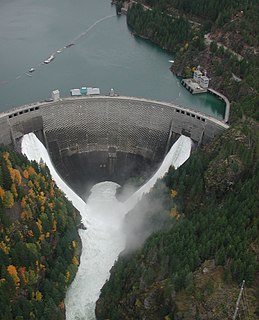
Ross Dam is a 540-foot (160 m)-high, 1,300-foot (400 m)-long concrete thin arch dam across the Skagit River, forming Ross Lake. The dam is in Washington state, while Ross Lake extends 23 miles (37 km) north to British Columbia, Canada. Both dam and reservoir are located in Ross Lake National Recreation Area, is bordered on both sides by Stephen Mather Wilderness and combined with Lake Chelan National Recreation Area they make up North Cascades National Park Complex.

Douglas Dam is a hydroelectric dam on the French Broad River in Sevier County, Tennessee, in the southeastern United States. The dam is operated by the Tennessee Valley Authority (TVA), which built the dam in record time in the early 1940s to meet emergency energy demands at the height of World War II. Douglas Dam is a straight reinforced concrete gravity-type dam 1705 feet long and 202 feet high, impounding the 28,420-acre (11,500 ha) Douglas Lake. The dam was named for Douglas Bluff, a cliff overlooking the dam site prior to construction.

Lake Pillsbury is a lake in the Mendocino National Forest of Lake County, California, created from the Eel River and Hull Mountain watershed by Scott Dam. Elevation is 1,818 ft (554 m) with 65 mi (105 km) of shoreline and covering 2,003 acres (811 ha). Activities in the Lake Pillsbury Recreation Area include powerboating, fishing, swimming, sailing, picnicking, hiking and hang gliding. There are two main access roads to the lake. At the north end of the lake is a small gravel airstrip. Over 400 homes including National Forest Recreational Residences ring this beautiful recreational lake.

Lake Shannon is a long, narrow reservoir on the Baker River in Skagit County, Washington in the United States. Formed in the 1920s by the construction of an arch dam just above the town of Concrete, the lake is approximately 7.5 miles (12 km) long and averages 0.6 miles (1 km) wide when full. Located just outside the western boundary of North Cascades National Park, Lake Shannon serves as the lower reservoir for Puget Sound Energy's Baker River Hydroelectric Project.

Lower Baker Dam is a dam across the Baker River one mile north of Concrete, Washington. It forms a reservoir called Lake Shannon which stretches 7.5 miles (12.1 km) upstream. The dam is operated by Puget Sound Energy as part of the Baker River Hydroelectric Project.
Upper Baker Dam is a dam spanning the Baker River in northern Washington in the United States of America. It is one of two dams on the river, the other one being the Lower Baker Dam a few miles downstream. The dam is used to generate hydroelectricity and provide flood control.
The Electron Hydroelectric Project, originally known as the Puyallup Project, is a hydroelectric power plant operated by Puget Sound Energy on the Puyallup River in Pierce County, Washington. It generates 22 megawatts (30,000 hp) of electricity and is operated and maintained by approximately 20 full-time employees.
The Koma Kulshan Project is a 13.3 MW run-of-the-river hydroelectric generation facility on the slopes of Mount Baker, a stratovolcano in Washington state's North Cascades. The project commenced commercial operation in October 1990, and is owned by a Covanta Energy–Atlantic Power joint venture. It supplies Puget Sound Energy via a Power Supply Agreement (PSA) contract. Its single turbine is a Pelton wheel supplied by Sulzer Escher Wyss.

Electricity in the Puget Sound region is a significant factor in people's lives, an enabler for the modern economy, and has a unique relationship with the region's environment.
The following outline is provided as an overview of and topical guide to infrastructure of the U.S. state of Washington.
Illabot Creek is a designated National Wild and Scenic River in Northern Washington which provides a spawning and rearing habitat for summer and fall chinook, coho, chum and pink salmon; as well as steelhead and bull trout. The creek is in the Skagit River watershed. Puget Sound Chinook, steelhead and bull trout are listed under the Endangered Species Act. Illabot Creek also supports the highest density of chum and pink salmon in the Skagit River watershed. The creek area also provides habitat for wintering bald eagles that are attracted to the salmon, part of one of the largest concentration of wintering bald eagles in the continental United States.


