
Johnson County is a county located in western portion of the U.S. state of Missouri. As of the 2010 census, the population was 52,595. Its county seat is Warrensburg. The county was formed December 13, 1834 from Lafayette County and named for Vice President Richard M. Johnson.

Barry County is a county located in the southwest portion of the U.S. state of Missouri. As of the 2010 Census, the population was 35,597. Its county seat is Cassville. The county was organized in 1835 and named after William Taylor Barry, a U.S. Postmaster General from Kentucky.
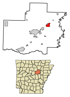
Bald Knob is a city in White County, Arkansas, United States. The population was 2,897 at the 2010 census. Located at the intersection of two of the state's natural regions, Bald Knob is often promoted as "where the Ozarks meet the Delta". Bald Knob is also a leading strawberry producer in the state, known for its yearly Strawberry Fest held during Mother's Day weekend. It was once known as the leading strawberry producer in the world. Bald Knob was established in 1881.

Pilot Knob is a city in Iron County, Missouri, United States. The population was 746 at the 2010 census. It lies eightteen miles south east of Belgrade and twenty seven miles north east of Centerville.

The Bald Knobbers were a group of vigilantes in the Ozark region of southwest Missouri from 1883 to 1889. They are commonly depicted wearing black horned hoods with white outlines of faces painted on them, a distinction that evolved during the rapid proliferation of the group into neighboring counties from its Taney County origins. The group got its name from the grassy bald knob summits of the nearby Ozark Mountains. The hill where they first met, Snapp's Bald, is located just north of Kirbyville, Missouri. An article in the October 5, 1898 issue of Springfield, Missouri's The Leader-Democrat states:
Henry Westmoreland is in from Beaver County, Oklahoma, which was formerly a part of the strip known as No-Man's-Land. He says grass is in abundance and cattle plenty, but no efforts are made at raising crops there, except roughness and alfalfa. The venerable gentleman owned a ranch in Taney County at the time of the Bald Knob uprising, and was the man who gave that organization its name.

Knob Lick is an unincorporated community in southern Saint Francois County, Missouri, United States. It is located on Missouri Route DD just east of U.S. Route 67 about eight miles south of Farmington.

Arcadia Valley in Missouri is located 80 miles south of St. Louis in the St. Francois Mountains of the Ozark Plateau. The valley includes of the towns of Arcadia, Ironton and Pilot Knob, all founded in the 19th century.
The Bald Knob Wilderness is a 5,973-acre (24.2 km²) parcel of land listed as a Wilderness Area of the United States. It is, by acreage, the largest wilderness area located within the U.S. state of Illinois. It is located within the Shawnee National Forest in northwestern Union County, Illinois.
Fort Hovey was a small Civil War era earth-and-wood fort built on a hill overlooking the junction of the road running south out of Ironton, Missouri and the road running east to Fredericktown, Missouri. Fort Hovey was intended to help protect the Arcadia Valley and the iron mines located on Pilot Knob. The fort was located on Fort Hill near the town of Arcadia, Missouri on the (then) property of the Fort Hill Methodist Episcopal Church, South and the present day Arcadia Valley United Presbyterian Church. This fortification was named Fort Hovey in honor of the commander of the 33rd Illinois Volunteer Infantry Regiment (Union), Colonel Charles E. Hovey. The 33rd. Illinois was stationed there during the Autumn and Winter of 1861-62, at which time they built the fort.
Knob Creek is a stream in Iron and St. Francois counties in the U.S. state of Missouri. It is a tributary of Stouts Creek.
Musco Creek is a stream in Madison and St. Francois counties in the U.S. state of Missouri. It is a tributary of the Little Saint Francis River.
Bain Hill is a summit in St. Francois County, Missouri. It has a peak elevation of 1,106 feet (337 m). The hill rises to the east of and about 200 feet above the Little St. Francis River. Knob Lick lies about four miles to the west and Mine La Motte is about five miles to the south in Madison County.
Gibson Hill is a summit in eastern St. Francois County in the U.S. state of Missouri. The summit has an elevation of 1,086 feet (331 m).
Gobble Hollow is a valley in eastern St. Francois County in the U.S. state of Missouri. It is a tributary to the Little Saint Francois River.
Libertyville is an unincorporated community in southeastern St. Francois County, in the U.S. state of Missouri. The community is on Missouri Route DD east of Knob Lick and north of Mine La Motte. The village sits at the headwaters of the Little Saint Francis River.
Oak Mountain is a summit in the southwestern corner of St. Francois County in the U.S. state of Missouri. The summit has an elevation of 1,631 feet (497 m). The peak is on a north-south trending ridge that extends south into Iron County and the city of Pilot Knob lies just southwest of the mountain. The community of Middlebrook is to the northwest and Iron Mountain Lake is to the north. The source area of Knob Creek is on the west flank of the mountain.
Rock Creek is a southwest flowing stream in Madison and St. Francois counties in the U.S. state of Missouri. It is a tributary of the Little Saint Francis River.
Seego Hollow is a valley in southern St. Francois County in the U.S. state of Missouri. The headwaters of the intermittent stream in Seego Hollow arise between Buck Mountain and Bald Knob at 37°39′30″N90°31′10″W. The stream confluence with Wachita Creek is at 37°39′27″N90°29′09″W.
Syenite is an unincorporated community in southern St. Francois County, in the U.S. state of Missouri. The community lies on Missouri Route DD west of U.S. Route 67. Knob Lick lies about 1.5 miles to the east and the St. Francis River valley is to the north and west. Knob Lick Mountain lies about one mile to the south-southeast.


