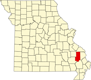
Iron County is a county located in the Lead Belt region in the U.S. state of Missouri. As of the 2020 census, the population was 9,537. The largest city and county seat is Ironton. Iron County was officially organized on February 17, 1857, and was named after the abundance of iron ore found within its borders.

The United States Congress designated the Bell Mountain Wilderness in 1980. The wilderness area now has a total of 9,027 acres (36.53 km2). Bell Mountain is located within the Potosi-Fredericktown Ranger District of the Mark Twain National Forest, south of Potosi, Missouri in the United States. The wilderness lies in the Saint Francois Mountains and it was named after its highest point, Bell Mountain. The namesake Bell Mountain has the name of Henry Bell, a pioneer settler. The Bell Mountain Wilderness is one of eight wilderness areas protected and preserved in Missouri. The area is popular for hiking as there are 12 miles (19 km) of trail, including a section of the Ozark Trail.
Bessville is an unincorporated community in the southern part of Crooked Creek Township in eastern Bollinger County, Missouri, United States. The community lies on the east bank of Crooked Creek and at the end of Missouri Route OO. It is located approximately seven miles northwest of Marble Hill and 5.5 miles southeast of Marquand in adjacent Madison County.
Abbott Branch is a stream in northern Iron County, Missouri. It is a tributary of Courtois Creek.
Cedar Creek is a stream in Iron and Washington counties in the U.S. state of Missouri. It is a tributary to Big River.
Claybaugh Creek is a stream in the Saint Francois Mountains of Iron County in the U.S. state of Missouri.
Ketcherside Mountain is a summit in Iron County in the U.S. state of Missouri. The peak lies about 4+1⁄2 miles (7 km) southeast of Taum Sauk Mountain and about 6+1⁄2 miles (10 km) south-southwest of Ironton. Hogan and Hogan Mountain lie to the west-southwest.
Minimum is an unincorporated community in southeastern Iron County, in the U.S. state of Missouri.
Ottery Creek is a stream in Iron and Reynolds counties in the U.S. state of Missouri. It is a tributary to the Middle Fork Black River.

Russell Mountain is a summit in Iron County in the U.S. state of Missouri. The mountain lies just east of Taum Sauk Mountain and Missouri Route CC provides access to the two peaks from combined Missouri routes 21 and 72 to the east. The town of Ironton is about six miles to the northeast. The Tom Sauk Trail traverses the Russell Mountain ridge.
Shepherd Mountain is a summit in Iron County in the U.S. state of Missouri. Shepherd Mountain lies just west of Ironton and Stouts Creek in the Arcadia Valley.
Stony Mountain is a summit in Iron County in the U.S. state of Missouri. Stony Mountain lies about 3.5 miles east of Annapolis and about four miles northeast of Vulcan on Missouri Route 49.

Stouts Creek is a stream in Iron and Madison counties in the U.S. state of Missouri. The stream headwaters lie just northwest of Taum Sauk Mountain and it flows north then east to cross under Missouri Route 21 between Ironton and Arcadia. It continues east passing under Missouri Route 72 and past Lake Killarney. It flows into Madison County to its confluence with the St. Francis River east of Roselle.
Vail Mountain is a summit in Iron County in the U.S. state of Missouri. The summit has an elevation of 1,404 feet (428 m). Vail Mountain lies to the east of Russell Mountain and the road to the summit of Taum Sauk Mountain passes just west of the summit of Vail Mountain. Routes 21 and 72 traverse the south spur of the mountain before heading south through Royal Gorge. The summit is about 3 miles (4.8 km) southwest of Arcadia and Ironton.
First Creek is a stream in eastern Iron and western St Francois counties in the U.S. state of Missouri. It is a tributary of the St. Francis River. The stream headwaters are at 37°40′01″N90°39′16″W and the confluence with the St. Francis ia at 37°42′13″N90°39′07″W. The stream source area lies northwest of Middlebrook and the stream flows northeast to north paralleling Missouri Route W. Just southwest of Iron Mountain the streamcourse veers northwest and re-enters Iron County to its confluence with the St. Francis.
Indian Creek is a stream in St. Francois County in the U.S. state of Missouri. It is a tributary of the St. Francis River.
Mineral City is an unincorporated community in southern St. Francois County, in the U.S. state of Missouri. The community lies on Missouri Route W, southwest of Doe Run. Stono Mountain and the headwaters of Doe Run Creek lie to the west.
Oak Mountain is a summit in the southwestern corner of St. Francois County in the U.S. state of Missouri. The summit has an elevation of 1,631 feet (497 m). The peak is on a north-south trending ridge that extends south into Iron County and the city of Pilot Knob lies just southwest of the mountain. The community of Middlebrook is to the northwest and Iron Mountain Lake is to the north. The source area of Knob Creek is on the west flank of the mountain.
Pine Mountain is a summit in St. Francois County in the U.S. state of Missouri. The summit has an elevation of 1,499 feet (457 m). The mountain is about 3.5 miles (5.6 km) south of Bismarck along Missouri Route N. The peak rises just south of the confluence of Indian Creek with the St. Francis River.
Stono Mountain is a summit in St. Francois County in the U.S. state of Missouri. The mountain rises to an elevation of 1,644 feet (501 m). Mineral City lies along the headwaters of Doe Run Creek just to the east on Missouri Route W and Little Stono Mountain lies to the north.