
Mount Charleston, including Charleston Peak at 11,916 feet (3,632 m), is the highest mountain in both the Spring Mountains and Clark County, in Nevada, United States. It is the eighth-highest mountain in the state. Well separated from higher peaks by large, low basins, Charleston Peak is the most topographically prominent peak in Nevada, and the eighth-most-prominent peak in the contiguous United States. It is one of eight ultra-prominent peaks in Nevada. It is located about 35 miles (56 km) northwest of Las Vegas within the Mount Charleston Wilderness, which is within the Spring Mountains National Recreation Area of the Humboldt–Toiyabe National Forest.

Wheeler Peak is the tallest mountain in the Snake Range and in White Pine County, in Nevada, United States. The summit elevation of 13,065 feet (3,982 m) makes it the second-highest peak in Nevada, just behind Boundary Peak. With a topographic prominence of 7,563 feet (2,305 m), Wheeler Peak is the most topographically prominent peak in White Pine County and the second-most prominent peak in Nevada, just behind Mount Charleston. The mountain is located in Great Basin National Park and was named for George Wheeler, leader of the Wheeler Survey of the late 19th century.
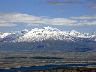
Ruby Dome is the highest mountain in both the Ruby Mountains and Elko County, in Nevada, United States. It is the twenty-seventh-highest mountain in the state, and also ranks as the thirteenth-most topographically prominent peak in the state. The peak is located about 21 miles (34 km) southeast of the city of Elko within the Ruby Mountains Ranger District of the Humboldt-Toiyabe National Forest. The mountain rises from a base elevation of about 6,000 feet (1,800 m) to a height of 11,387 feet (3,471 m). It is the highest mountain for over 90 miles in all directions.

Pilot Peak is the highest mountain in the Pilot Range in extreme eastern Elko County, Nevada, United States. It is the most topographically prominent peak in Elko County and the fourth-most prominent peak in Nevada. The peak is on public land administered by the Bureau of Land Management and thus has no access restrictions.

Arc Dome is the highest mountain of the Toiyabe Range in northwestern Nye County, Nevada, United States. It is the thirteenth-highest mountain in the state. Arc Dome also ranks as the second-most topographically prominent peak in Nye County and the eighth-most prominent peak in the state. The peak is located about 53 miles (85 km) north of the community of Tonopah, within the Arc Dome Wilderness of the Humboldt-Toiyabe National Forest.

Mount Jefferson is the highest mountain in both the Toquima Range and Nye County in Nevada, United States. It is the sixth highest mountain in the state. As the high point of a range which is well separated from other ranges by low basins, Mount Jefferson has a high topographic prominence of 5,861 feet (1,786 m). This makes it the most prominent peak in Nye County and the third most prominent peak in Nevada. For similar reasons, it is also the highest mountain for over 90 miles in all directions. It is located about 50 miles (80 km) northeast of the county seat of Tonopah within the Alta Toquima Wilderness of the Humboldt-Toiyabe National Forest, near the smaller towns of Carvers and Round Mountain. Three distinct summits are located on a broad area of subalpine tundra: North Summit rises to 11,820 feet (3,603 m), Middle Summit to 11,692 feet (3,564 m), and South Summit to 11,949 feet (3,642 m). During the Pleistocene, alpine glaciers eroded several cirques east of the summit plateau.

North Schell Peak is the highest mountain in the Schell Creek Range of White Pine County, Nevada, United States. It is the ninth-highest mountain in the state, and also ranks as the fifth-most topographically prominent peak in the state. The summit is 19 miles (31 km) northeast of the community of Ely within the High Schells Wilderness of the Humboldt-Toiyabe National Forest.

Troy Peak is the highest mountain in the Grant Range in northeastern Nye County, Nevada, United States. It is the thirty-sixth highest mountain in Nevada. Troy Peak also ranks as the third-most topographically prominent peak in Nye County and the fourteenth-most prominent peak in the state. The summit is located 72 miles (116 km) southwest of the city of Ely, within the Grant Range Wilderness of the Humboldt-Toiyabe National Forest.
Hayford Peak, elevation 9,924 feet (3,025 m), is the highest mountain in the Sheep Range of Clark County, Nevada, United States. It is the seventh-most topographically prominent peak in the state. The nearest taller mountain is Mount Charleston, 34 miles (55 km) to the southwest. In the winter months, there is snow on the peak, which usually lasts until early spring.

Star Peak is both the highest and most topographically prominent mountain in both the Humboldt Range and Pershing County in Nevada, United States. It is the sixth-most topographically prominent peak in Nevada. The peak is on public land administered by the Bureau of Land Management and has no access restrictions.
Mount Augusta is the highest mountain in the Clan Alpine Mountains of Churchill County in Nevada, United States. It is the most topographically prominent peak in Churchill County and ranks nineteenth among the most topographically prominent peaks in Nevada. The peak is on public land administered by the Bureau of Land Management and thus has no access restrictions.
Mount Siegel is the highest mountain in the Pine Nut Mountains of Douglas County in Nevada, United States. It is the most topographically prominent peak in Douglas County and ranks forty-sixth among the most topographically prominent peaks in Nevada. The peak is on public land administered by the Bureau of Land Management and thus has no access restrictions.
Piper Peak is the highest mountain in the Silver Peak Range of Esmeralda County in Nevada, United States. It is the most topographically prominent peak in Esmeralda County and ranks twenty-third among the most topographically prominent peaks in Nevada. The peak is on public land administered by the Bureau of Land Management and thus has no access restrictions.
Mormon Peak is the highest mountain in the Mormon Mountains of Lincoln County in Nevada, United States. It is the most topographically prominent peak in Lincoln County and ranks twenty-fourth among the most topographically prominent peaks in Nevada. The peak is on public land administered by the Bureau of Land Management and thus has no access restrictions.
Virginia Peak is the highest mountain in the Pah Rah Range of Washoe County in Nevada, United States. It is the most topographically prominent peak in Washoe County and ranks thirty-sixth among the most topographically prominent peaks in Nevada. The peak is on public land administered by the Bureau of Land Management and thus has no access restrictions. A National Weather Service NEXRAD doppler weather radar station is located on the summit.
Quinn Peak is the highest mountain in the Jackson Mountains of Humboldt County in Nevada, United States. It is the most topographically prominent peak in Humboldt County and ranks tenth among the most topographically prominent peaks in Nevada. The peak is on public land administered by the Bureau of Land Management and thus has no access restrictions.
Mount Tobin is the highest mountain in the Tobin Range of Pershing County in Nevada, United States. It is the second-most topographically prominent peak in Pershing County and ranks twelfth among the most topographically prominent peaks in Nevada. The peak is on public land administered by the Bureau of Land Management and thus has no access restrictions, though private property is located along the most popular route to the summit.
Grapevine Peak is the highest mountain in the Grapevine Mountains of Nye County in Nevada, United States. It is the fourth-most topographically prominent peak in Nye County and ranks seventeenth among the most topographically prominent peaks in Nevada. The peak is located within the boundaries of Death Valley National Park.
