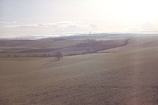
Hilton is a village and civil parish in the county of Dorset in southern England. It is sited at an elevation of 135 metres in a small valley which drains chalk hills in the eastern part of the Dorset Downs, approximately 8 miles west-southwest of the town of Blandford Forum. The summit of Bulbarrow Hill is 1+1⁄2 miles north of the village. In the 2011 census the parish—which includes the settlement of Ansty to the west—had 231 dwellings, 206 households and a population of 477.
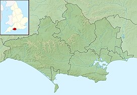
The Dorset Downs are an area of chalk downland in the centre of the county Dorset in south west England. The downs are the most western part of a larger chalk formation which also includes Cranborne Chase, Salisbury Plain, Hampshire Downs, Chiltern Hills, North Downs and South Downs.
Interstate 684 (I-684) is a 28.47-mile (45.82 km) auxiliary Interstate Highway in the state of New York in the United States. There is also a short portion in Connecticut with no junctions. The highway connects I-84 with I-287 and the Hutchinson River Parkway, primarily serving commuter traffic to and from the northern suburbs of the New York metropolitan area. Most of the route is in northern Westchester County. The route of the highway was originally designated as part of I-87 from 1968 to 1970. The first section of the roadway opened to traffic in October 1968, and the final segment was completed in December 1974.

East Woodhay is a village and civil parish in Hampshire, England. The village is approximately 5.5 miles (9 km) south-west of Newbury in Berkshire. At the 2011 census the parish had a population of 2,914.
Deadwood is a hamlet in Alberta, Canada within the County of Northern Lights. It is located on Highway 690, approximately 10 kilometres (6.2 mi) east of the Mackenzie Highway, 80 kilometres (50 mi) north of Peace River and 34 kilometres (21 mi) southeast of Manning.

Knott is a mountain in the northern part of the English Lake District. It is the highest point of the Back o'Skiddaw region, an area of wild and unfrequented moorland to the north of Skiddaw and Blencathra. Other tops in this region include High Pike, Carrock Fell and Great Calva. The fell's slopes are mostly smooth, gentle, and covered in grass, with a few deep ravines. It stands a long way from a road and requires a long walk across the moor top get to it; this, as well as the fact that it is hidden from the rest of the Lake District by the two aforementioned giants, make it one of the most unfrequented tops in the Lakes. When it is climbed it is most often from Mungrisdale or from the north via Great Sca Fell. The word Knott is of Cumbric origin, and means simply "hill".

At 316 metres (1,037 ft) above sea level, Walton Hill is the highest point in the range of hills in northern Worcestershire known as the Clent Hills. It is the highest point for 21 miles (34 km) in all directions, and as such commands an excellent panorama. Its neighbours include Clent Hill, Wychbury Hill, Calcot Hill, and Romsley Hill.

Grisedale Pike is a fell in the Lake District, Cumbria, England, situated 4+1⁄2 miles west of the town of Keswick in the north-western sector of the national park. At a height of 791 metres it is the 40th-highest Wainwright in the Lake District; it also qualifies as a Hewitt, Marilyn and Nuttall. Grisedale Pike presents a striking appearance when viewed from the east, particularly from the vicinity of Keswick. It possesses two subsidiary summits: one unnamed ; the other Hobcarton End.

New York State Route 309 (NY 309) is a 6.56-mile-long (10.56 km) state highway located entirely in Fulton County, New York, in the United States. The southern terminus of the route is at an intersection with NY 29A in Gloversville. The northern terminus of the route is at a junction with Lily Lake Road in the hamlet of Bleecker, where the highway continues north and west as County Route 112 (CR 112) to London Bridge Road at West Caroga Lake in the town of Caroga. Part of NY 309 and all of CR 112 is located within Adirondack Park. NY 309 was assigned to its current alignment as part of the 1930 renumbering of state highways in New York.
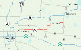
Alberta Provincial Highway No. 29, commonly referred to as Highway 29, is a 153-kilometre (95 mi) highway in east–central Alberta, Canada that connects Highway 15 near Lamont to Highway 41 north of Elk Point. It runs mostly west to east across aspen parkland through Hairy Hill, turning north through Duvernay, Brosseau, Foisy, St. Brides, and east to St. Paul before ending at Highway 41 approximately 9 km (5.6 mi) north of Elk Point, concurrent with Highways 36 and 45 for lengthy sections.

Brace Mountain is the peak of a ridge in the southern Taconic Mountains, near the tripoint of the U.S. states of New York, Connecticut and Massachusetts. Its 2,311-foot (704 m) main summit is located in New York; it is the highest point in that state's Dutchess County.

Ben Mor Coigach is the highest point along a ridge rising steeply from Loch Broom, in the far northwest of Scotland. It rises above the Coigach peninsula in the county of Ross and Cromarty, 10 kilometres northwest of Ullapool, reaching a height of 743 metres (2,438 ft). Its coastal position, combined with its high topographic prominence to height ratio, provides a spectacular panorama, sweeping from Ullapool across to the Summer Isles and north over the Coigach to the distinctive peaks of the Assynt, as well as more distant views to Skye and the Outer Hebrides, conditions permitting. The area is a Scottish Wildlife Trust nature reserve.

Garraun at 598 metres (1,962 ft), is the 224th–highest peak in Ireland on the Arderin scale, however, while it is just short of the elevation threshold of 600-metres for other classifications, it does have the prominence to be a Marilyn. Garraun lies on an isolated massif near the mouth of Killary Harbour at the far north sector of the Twelve Bens/Garraun Complex Special Area of Conservation in the Connemara National Park in County Galway. The southern slopes are a scenic backdrop to Kylemore Abbey and Kylemore Lough.

Bookham Knoll is a rounded hill, 211 metres (692 ft) high, about 1 kilometre southeast of the village of Buckland Newton in the county of Dorset in southern England. Its prominence of 43 metres (141 ft) qualifies it as one of the Tumps. It is located within the Dorset Downs.
Mahimangad Fort, in Maan lies within the village limits of Mahimangad village about five and a half miles west of Dahivadi.
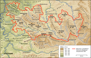
The Limpurg Hills are a hill range, up to 564.7 m above sea level (NHN), in the Swabian-Franconian Forest in the counties of Schwäbisch Hall and Ostalbkreis in the German state of Baden-Württemberg. The majority of the region belonged formerly to Limpurg Land owned by the family of Schenken von Limpurg, whose name was derived from their family home, Limpurg Castle near Schwäbisch Hall.

Black Edge is a summit, 507 metres (1,663 ft) high, on a sharp ridgeline above the village of Dove Holes in the Dark Peak area of the Peak District in the county of Derbyshire in England.
The Totenkopf is a hill 502.6 m above sea level (NHN), on the Brilon Heights in the counties of Hochsauerlandkreis and Paderborn, in the German state of North Rhine-Westphalia.

Schlüsselstein Castle was a castle and the seat of a noble family, probably dating to the High Middle Ages, the remains of which lie above the town of Ebermannstadt in the Upper Franconian county of Forchheim in the south German state of Bavaria. The site is known locally as Burgstall Schlüsselstein.