
Cloncurry is a rural town and locality in the Shire of Cloncurry, Queensland, Australia. It is informally known by local people as The Curry. In the 2021 census, the locality of Cloncurry had a population of 3,167 people.

Dajarra is a rural town and a locality in the Shire of Cloncurry, Queensland, Australia. In the 2021 census, the locality of Dajarra had a population of 186 people.
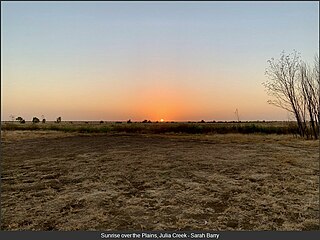
Julia Creek is an outback town and locality in the Shire of Mckinlay, Queensland, Australia. In the 2021 census, the locality of Julia Creek had a population of 549 people.

Mary Kathleen was a mining settlement in north-western Queensland, Australia. It is located in the Selwyn Range between Mount Isa and Cloncurry.

Jennings is a town on the Northern Tablelands region of New South Wales, Australia. The town is located in the Tenterfield Shire local government area, 718 kilometres (446 mi) from the state capital, Sydney and 256 kilometres (159 mi) from Brisbane. It is separated by the state border from its neighbouring town of Wallangarra in Queensland. At the 2011 census, Jennings had a population of 211. The New England Highway and the Main North railway line cross the state border at Jennings. The town was named for Sir Patrick Jennings, the first Roman Catholic Premier of New South Wales.
Dajarra and Selwyn Branch Railways were lines in north-west Queensland, Australia. Along with the Mount Cuthbert and Dobbyn Branch Railways, they were essentially built to tap large deposits of copper discovered in the Cloncurry region.
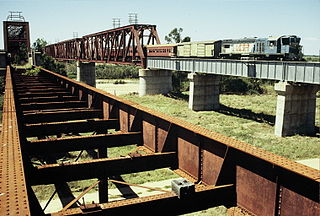
The Great Northern Railway is a 1067 mm gauge railway line in Queensland, Australia. The line stretches nearly 1,000 kilometres linking the port city of Townsville, Australia to the mining town of Mount Isa in north-west Queensland. Along with a passenger service called the Inlander, it is a major freight route connecting the Mount Isa Mines to the Port of Townsville. In 2010, the line moved 5.8 million tonnes of cargo, and this is expected to increase significantly in coming years.

McKinlay is an outback town and locality in McKinlay Shire, Queensland, Australia. In the 2021 census, the locality of McKinlay had a population of 162 people.
Kajabbi is a rural town in the locality of Three Rivers, Shire of Cloncurry, Queensland, Australia.

Duchess is a rural town and locality in the Shire of Cloncurry, Queensland, Australia. In the 2021 census, the locality of Duchess had a population of 53 people.
Nelia is an outback town in the locality of Julia Creek in the Shire of Mckinlay, Queensland, Australia.
Mount Cuthbert is a former copper mining town in the locality of Three Rivers, Shire of Cloncurry, Queensland, Australia. It is now a ghost town.
Selwyn is a rural town and locality in the Shire of Cloncurry, Queensland, Australia. Selwyn is now an abandoned mining town. In the 2021 census, the locality of Selwyn had a population of 25 people.
Alfred James "Norm" Smith was a businessman, and member of the Queensland Legislative Assembly.
Kuridala is a rural locality in the Shire of Cloncurry, Queensland, Australia. It contains the former mining town of the same name. In the 2021 census, Kuridala had a population of 38 people.

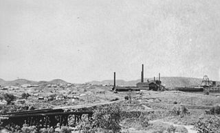
Kuridala Township site is a heritage-listed mining camp in the locality of Kuridala, Shire of Cloncurry, Queensland, Australia. It was built from 1880s to 1920s. It is also known as Hampden Township, Hampden Smelter, Kuridala Smelter, and Friezeland Township. It was added to the Queensland Heritage Register on 12 June 2009.
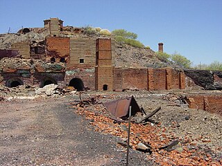
Mount Elliott Mining Complex is a heritage-listed copper mine and smelter at Selwyn, Shire of Cloncurry, Queensland, Australia. It was designed by William Henry Corbould and built in 1908. It is also known as Mount Elliott Smelter and Selwyn. It was added to the Queensland Heritage Register on 16 September 2011.
Mount Isa is a rural locality in the City of Mount Isa, Queensland, Australia. It is the land that surrounds the suburbs of the town of Mount Isa. In the 2021 census, the locality of Mount Isa had a population of 172 people.
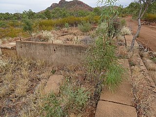
Wee MacGregor railway is a heritage-listed tramway and railway associated with the former towns of Ballara and Hightville in the locality of Kuridala, Shire of Cloncurry, Queensland, Australia. It was built from 1909 to 1926. It was added to the Queensland Heritage Register on 1 March 2019.
Cloncurry–Dajarra Road is a continuous 169 kilometres (105 mi) road route in the Cloncurry local government area of Queensland, Australia. It is a state-controlled district road rated as a local road of regional significance (LRRS). It is a north-east to south-west link between the Barkly Highway and the Diamantina Developmental Road, servicing a number of cattle grazing and production areas in northern Queensland.
