Related Research Articles
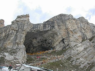
The Amarnath Temple is a Hindu shrine located in the Pahalgam tehsil of the Anantnag district of Jammu and Kashmir, India. A cave situated at an altitude of 3,888 m (12,756 ft), about 168 km from Anantnag city, the district headquarters, 141 km (88 mi) from Srinagar, the summer capital of Jammu and Kashmir, reached through either Sonamarg or Pahalgam. It is an important shrine in Hinduism. The cave, located in Sind Valley, is surrounded by glaciers, snowy mountains and is covered with snow most of the year, except for a short period in the summer, when it is open to pilgrims. In 1989, pilgrims numbered between 12,000 and 30,000. In 2011, the numbers reached a peak, crossing 6.3 lakh (630,000) pilgrims. In 2018 pilgrims numbered 2.85 lakh (285,000). The annual pilgrimage varies between 20 and 60 days.

Ganderbal is a town and a municipality committee in Ganderbal district in the Indian union territory of Jammu and Kashmir. It is the headquarters of Ganderbal district.It is in Central Kashmir, it has an average elevation of 1,619 metres. It is bordered by district Srinagar in the south, Bandipore to the north, Kargil in the northeast, Anantnag to the south-east and Baramulla in the south-west.The current District Magistrate of Ganderbal is Mr. Shyambir Singh.District Ganderbal is known for its beauty,there are many beautiful places in Ganderbal.Sonmarg is the most famous place in Ganderbal, Shri Amarnath Ji Yatra is also done in Ganderbal.

Pahalgam, known as Pahalgom is a town and a notified area committee, near Anantnag city in the Anantnag district of the Indian-administered union territory of Jammu and Kashmir. It is a popular tourist destination and hill station. Its lush green meadows and pristine waters attract thousands of tourists from all over the world each year. It is located 45 kilometres (28 mi) from Anantnag on the banks of Lidder River at an altitude of 7,200 feet (2,200 m). Pahalgam is the headquarters of one of the eleven tehsils of Anantnag district.
The 2000 Amarnath pilgrimage attack on 1 and 2 August was the massacre of at least 89 to 105 people and injury to at least 62 people, in at least five different coordinated attacks by Islamist militants in Anantnag district and Doda district of Indian administered Kashmir.

Sonamarg or Sonmarg, known as Sonamarag in Kashmiri, is a hill station located in the Ganderbal District of Jammu and Kashmir, India. It is located about 62 kilometers from Ganderbal Town and 80 kilometres (50 mi) northeast of the capital city, Srinagar.

The valleys of Jammu and Kashmir include the Kashmir Valley, Chenab Valley, Sindh Valley, and Lidder Valley. Srinagar, with its renowned Dal Lake and Mughal Gardens, Gulmarg, Pahalgam, Bhaderwah, Patnitop, and Jammu are all popular tourist destinations in Jammu and Kashmir. Thousands of Hindu pilgrims visit the sacred temples of Vaishno Devi and Amarnath each year, which has a substantial impact on the state's economy.
On 26 May 2008, the government of India and the state Government of Jammu and Kashmir reached an agreement to transfer 99 acres (0.40 km2) of forest land to the Shri Amarnathji Shrine Board (SASB) in the main Kashmir valley to set up temporary shelters and facilities for Hindu pilgrims. This caused a controversy, with demonstrations from the Kashmir valley against the land transfer and protests from the Jammu region supporting it. The largest demonstration saw more than 500,000 protesters at a single rally, among the largest in Kashmir's history.

The Ganderbal (گاندربل) district, or more formally District Ganderdal, is an administrative district of Indian-administered Jammu and Kashmir in the disputed Kashmir region. Ganderbal town is administrative headquarters of district. It was formed in 2007 and has 6 subdistricts (tehsils): Kangan, Ganderbal, Tullamulla, Wakura, Lar, and Gund.

Manasbal Lake is a freshwater lake located in Safapora area of Ganderbal District in Jammu and Kashmir, India. The name Manasbal is said to be a derivative of Manasarovar. The lake is encircled by four villages viz., Jarokbal, Kondabal, Nesbal and Gratbal. The large growth of lotus at the periphery of the lake adds to the beauty of the clear waters of the lake. The Mughal garden, called the Jaroka Bagh, built by Nur Jahan overlooks the lake.
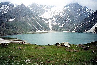
Sheshnag Lake is an alpine high elevation oligotrophic lake located in Anantnag district of Kashmir Valley in Jammu and Kashmir, India at an elevation of 3590 meters. It is situated on the track leading to the Amarnath cave, about 23 km from Pahalgam. It has a maximum length of 1.1 km and maximum width of 0.7 km.
Sirbal Peak is a mountain with a peak elevation of 5,235 metres (17,175 ft), in the Ganderbal district of the Indian union territory of Jammu and Kashmir, in the vicinity of Sonamarg. Sirbal Peak is part of the Himalaya Range, and is located between Sonamarg and Baltal. It lies 102 km northeast from Srinagar, 5 km from Sonamarg in the east. Sirbal Peak lies 6 km west of Zojila. It rises from a glacier 5 km ahead from Sonamarg on left side of NH 1D. The melt waters from the glacier add to the flow of Nallah Sindh.
Amarnath Peak is a mountain with a peak elevation of 5,186 metres (17,014 ft), in the Ganderbal district of the Indian union territory of Jammu and Kashmir, in the vicinity of Sonamarg. Amarnath Peak is part of the Himalayas, and is located south of Zojila and west of Machoi Glacier. It lies 117 km northeast from Srinagar, 13 km from Baltal in the southeast. It lies 6 km south of Zojila. The melt waters form a major tributary of the Sind River at Baltal.
Lar is a town and council district in the Ganderbal district of central Kashmir, in Jammu and Kashmir, India. It is a relatively newly established tehsil, carved out of the Ganderbal tehsil. It is situated 25 km from the heart of the summer capital, Srinagar, on National Highway between the foothills of the Himalayan mountains in the north and the picturesque Zabarwan Hills in the south. The Sind River, a major tributary to the Jehlum River flows through Lar. The famous Manasbal Lake lies a few kilometres away from the town centre.
The Western Himalayas refers to the western half of the Himalayas, in northwestern India and northern Pakistan. Four of the five tributaries of the Indus River in Punjab rise in the Western Himalayas; while the fifth, the Sutlej cuts through the range after rising in Tibet.

The Z-MorhTunnel is an under-construction 6.5 km long 2-lane road tunnel between Gagangair and Sonamarg in Ganderbal district of Union Territory of Jammu and Kashmir in India. It is named after the Z-shaped stretch of road that the tunnel will replace. The road is avalanche-prone and gets blocked for several months. The Z-Morh tunnel will provide all-weather connectivity to the Sonamarg tourist town. It will take only 15 minutes to travel the 6.5 km long tunnel compared to hours over the zig-zag road up and down the hills.
On 10 July 2017, the first Monday of the month of Shraavana, 8 Hindu civilian pilgrims on the way from Amarnath Temple in Kashmir Valley, in the Indian state of Jammu and Kashmir, were killed in a terror attack. The pilgrims mostly belonged to the Indian state of Gujarat. Eight people were killed and at least 18 people were injured in the attack.
On 20 July 2001, in the month of Shraavana, 13 people were killed and 15 other injured in a terror attack on a pilgrim night camp at Sheshnag Lake near the Amarnath Temple glacial cave shrine in Kashmir Valley in the Indian state of Jammu and Kashmir, in two explosions and firing by militants. In a pre-dawn attack, terrorists penetrated several layers of security cordon and exploded two improvised explosive devices (lEDs), casualties included 8 Hindu civilian pilgrims entailing 2 women, and 3 Muslim civilians and 2 security personnel.
On 30 July and 6 August 2002, in the month of Shraavana, 11 people were killed and 30 injured in a terror attack by Islamic extremists from Lashkar-e-Taiba's front group of al-Mansuriyan, on Nunwan base camp at Pahalgam of the Amarnath Hindu pilgrimage (Yatra) to Amarnath Temple glacial cave shrine in Kashmir Valley in the Indian state of Jammu and Kashmir. In the spate of attacks on Yatra in the third consecutive year, 2 pilgrims were killed and 3 injured on 30 July when terrorists threw grenades at a civilian taxi of pilgrims in Srinagar. Further, 9 people were killed and 27 injured on 6 August by Lashkar-e-Taiba (LeT) terrorists' hail of bullets at Nunwan base camp at Pahalgam.

Panchtarni is a locality in Anantnag district of the Indian union territory of Jammu and Kashmir. It is a popular pilgrimage and tourist destination on the way to Amarnath Temple near the Amarnath Glacier in Himalayas. It is located 40 kilometres (25 mi) from Pahalgam base camp and 15 kilometres (9.3 mi) ahead of last halt camp of Sheshnag Lake in the north. It is a meadowland on the banks of eponymous Panchtarni River where five glacier-fed tributary streams meet in eponymous Panchtarni Valley surrounded by snow-capped mountains at an altitude of 11,500 feet (3,500 m). It is also the final helicopter drop off for the Amarnath yatra pilgrims, who have to trek the rest of the 6 kilometres (3.7 mi) journey either on foot or by mule from this camp.
Ganderbal Assembly constituency is one of the 87 constituencies in the Jammu and Kashmir Legislative Assembly of Jammu and Kashmir a north state of India. Ganderbal is also part of Srinagar Lok Sabha constituency.
References
- ↑ "Baltal". The Times of India . Archived from the original on 28 September 2011. Retrieved 21 August 2013.
- 1 2 "Baltal, Jammu & Kashmir". mustseeIndia.com. Archived from the original on 1 August 2013. Retrieved 21 August 2013.