
Goobang is a national park located in New South Wales, Australia, 296 kilometres (184 mi) northwest of Sydney. It protects the largest remnant forest and woodland in the central west region of the state, where interior and coastal New South Wales flora and fauna species overlap. Originally named Herveys Range by John Oxley in 1817, the area was reserved in 1897 as state forest because of its importance as a timber resource, and was designated a national park in 1995.
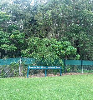
The Mooloolah River National Park is a nationally protected area located on the Sunshine Coast, Queensland. It covers an area of 830.9 hectares and is bordered by the Mooloolah River to the east, Claymore and Dixon Roads to the west, and the Lower Mooloolah River Environmental Reserve to the south. It is bisected by the Sunshine Motorway with the northern, 161.93 hectare component of the Park being a later addition. The Park was initially vacant crown land prior to national park designation in 1960. Surrounding land uses include livestock grazing, urban development and the campus of the University of the Sunshine Coast. It is the second largest mainland park on the coastal lowlands in South East Queensland after Noosa National Park and represents an example of low-lying coastal floodplain distinctive of the region.

Southwest Australia is a biogeographic region in Western Australia. It includes the Mediterranean-climate area of southwestern Australia, which is home to a diverse and distinctive flora and fauna.

Banksia ilicifolia, commonly known as holly-leaved banksia, is a tree in the family Proteaceae. Endemic to southwest Western Australia, it belongs to Banksia subg. Isostylis, a subgenus of three closely related Banksia species with inflorescences that are dome-shaped heads rather than characteristic Banksia flower spikes. It is generally a tree up to 10 metres (33 ft) tall with a columnar or irregular habit. Both the scientific and common names arise from the similarity of its foliage to that of the English holly Ilex aquifolium; the glossy green leaves generally have very prickly serrated margins, although some plants lack toothed leaves. The inflorescences are initially yellow but become red-tinged with maturity; this acts as a signal to alert birds that the flowers have opened and nectar is available.

The Swan Coastal Plain in Western Australia is the geographic feature which contains the Swan River as it travels west to the Indian Ocean. The coastal plain continues well beyond the boundaries of the Swan River and its tributaries, as a geological and biological zone, one of Western Australia's Interim Biogeographic Regionalisation for Australia (IBRA) regions. It is also one of the distinct physiographic provinces of the larger West Australian Shield division.

Banksia attenuata, commonly known as the candlestick banksia, slender banksia, or biara to the Noongar people, is a species of plant in the family Proteaceae. Commonly a tree, it reaches 10 m (33 ft) high, but it is often a shrub in drier areas 0.4 to 2 m high. It has long, narrow, serrated leaves and bright yellow inflorescences, or flower spikes, held above the foliage, which appear in spring and summer. The flower spikes age to grey and swell with the development of the woody follicles. The candlestick banksia is found across much of the southwest of Western Australia, from north of Kalbarri National Park down to Cape Leeuwin and across to Fitzgerald River National Park.

Banksia menziesii, commonly known as firewood banksia, is a species of flowering plant in the genus Banksia. It is a gnarled tree up to 10 m (33 ft) tall, or a lower spreading 1–3 m (3.3–9.8 ft) shrub in the more northern parts of its range. The serrated leaves are dull green with new growth a paler grey green. The prominent autumn and winter inflorescences are often two-coloured red or pink and yellow, and their colour has given rise to more unusual common names such as port wine banksia and strawberry banksia. Yellow blooms are rarely seen.

Eucalyptus gomphocephala, known as tuart, is a species of tree, one of the six forest giants of Southwest Australia. Tuart forest was common on the Swan coastal plain, until the valuable trees were felled for export and displaced by the urban development around Perth, Western Australia. The wood is dense, hard, water resistant and resists splintering, and found many uses when it was available. Remnants of tuart forest occur in state reserves and parks, the tree has occasionally been introduced to other regions of Australia and overseas. Remaining trees are vulnerable to phytophthora dieback, an often fatal disorder, including a previously unknown species discovered during analysis of dead specimens.
Assemblages of plants and invertebrate animals of tumulus springs of the Swan Coastal Plain are ecological communities in Western Australia. They have been managed under a number of other, similar names, including Mound springs of the Swan Coastal Plain and Communities of Tumulus Springs . The tumulus mounds were common to a narrow range of groundwater discharge at the boundary of 'bassendean sand' and 'guildford clay', along the edge of the Gnangara Mound aquifer. The communities are critically endangered.

The Avon Wheatbelt is a bioregion in Western Australia. It has an area of 9,517,104 hectares. It is considered part of the larger Southwest Australia savanna ecoregion.

Yalgoo is an interim Australian bioregion located in Western Australia. It has an area of 5,087,577 hectares. The bioregion, together with the Avon Wheatbelt and Geraldton Sandplains bioregions, is part of the larger Southwest Australia savanna ecoregion as classified by the World Wildlife Fund.

Western Australia occupies nearly one third of the Australian continent. Due to the size and the isolation of the state, considerable emphasis has been made of these features; it is the second largest administrative territory in the world, after Yakutia in Russia, despite the fact that Australia is only the sixth largest country in the world by area, and no other regional administrative jurisdiction in the world occupies such a high percentage of a continental land mass. It is also the only first level administrative subdivision to occupy the entire continental coastline in one cardinal direction.
Tasmania can be broadly divided into two distinct regions, eastern and western, that exhibit major differences in climate, geology and vegetation. This divide, termed Tyler’s Corridor, runs from just south of the northwestern corner, and continues south, cutting roughly down the center of the island. The vegetation changes occur principally due to variations in soil types, which are a result of the geological composition, and the vast difference in climate across the state. Generally, the west has a higher mean rainfall but poor acidic soil while the east has a lower mean rainfall but slightly more fertile soil. This results in a larger proportion of rainforest, moorland and wet sclerophyll vegetation dominating in the west and predominantly dry sclerophyll in the east.
Corymbia calophylla – Xanthorrhoea preissii woodlands and shrublands of the Swan Coastal Plain is an ecological community in the Southwest Australia ecoregion.

Kensington bushland reserve is a significant remnant of Swan Coastal Plain vegetation, that has been reserved in the suburb of Kensington, in Perth, Western Australia, by the state government.

The ecology of Sydney, located in the state of New South Wales, Australia, is diverse for its size, where it would mainly feature biomes such as grassy woodlands and some sclerophyll forests, with a few pockets of mallee shrublands, subtropical and temperate rainforests (evergreen), heathlands, and wetlands. The combination of climate, topography, moisture, and soil influence the dispersion of these ecological communities across a height gradient from 0 to 200 metres. There are many hiking trails, paved and unpaved roads for exploring the many different biomes and ecosystems.
Wide Bay Military Reserve is a heritage-listed military installation at Tin Can Bay Road, Tin Can Bay, Queensland, Australia. The reserve supports a diverse range of plant communities from estuarine, strand, wetlands, heath, tall shrublands and woodlands, to the open forests of the sub-coastal hills and ranges. The total number of bird species recorded for the place totals 250, which is high by Australian standards. It was added to the Australian Commonwealth Heritage List on 22 June 2004.

The Swan Coastal Plain Shrublands and Woodlands is a sclerophyll-woodland vegetation community that stretch from Kalbarri in the north to Busselton in the south, passing through Perth, in Western Australia. Situated on the Swan Coastal Plain, it is listed as Endangered under the Commonwealth Environment Protection and Biodiversity Conservation Act 1999. The woodlands also incorporate Perth–Gingin Shrublands and Woodlands.
