Baranof Warm Springs, Alaska

Last updated
Baranof Warm Springs
Sitka
Populated Place
Baranof Warm Springs2.jpg
Baranof Warm Springs and the rapids from Baranof Lake's outlet.
USA Alaska location map.svg
Red pog.svg
Baranof Warm Springs
Location in Alaska
Coordinates: 57°05′22″N134°49′59″W / 57.08944°N 134.83306°W / 57.08944; -134.83306
CountryUnited States
State Alaska
Borough Sitka City and Borough
Elevation
95 ft (29 m)
Time zone UTC-9 (Alaska (AKST))
  Summer (DST) UTC-8 (AKDT)
ZIP code
99835
Area code 907
FIPS code 02-05090
GNIS feature ID 1420227

Baranof Warm Springs is a small, primarily seasonally-occupied community located in the city and borough of Sitka, Alaska, on the eastern side of Baranof Island, from which it likely derives its name, [1] in the Alexander Archipelago. It is occasionally referred to simply as Baranof. Baranof Warm Springs is located at 57°05′22″N134°49′59″W / 57.08944°N 134.83306°W / 57.08944; -134.83306 .

Contents

Geography

Baranof Warm Springs is located on Warm Springs Bay which is just off of Chatham Strait. Just about a half mile up from the settlement is Baranof Lake, a large glacially-fed freshwater lake. Baranof Lake is fed from small unnamed glacial run-off streams as well as the relatively large Baranof River. Between the half mile outlet between Baranof Lake and Warm Springs Bay there are a series of rapids and waterfalls that have proven to be lethal when run.[ citation needed ]

Baranof Warm Springs is located on the southern part of a 34-mile-long (55 km), 5-to-10-mile-wide (8.0 to 16.1 km) exposure of a biotite-quartz diorite batholith that crosses northern Baranof Island. [2]

Community

Baranof Warm Springs Baranof Warm Springs1.jpg
Baranof Warm Springs

Baranof Warm Springs is a very small community, having only caretakers in the winter and intermittent visitors in the summer. There are around 15 seasonal homes. The community lies inside the jurisdiction of the City and Borough of Sitka. Other than property taxes and any dock fees from the new dock (2016) there is only one tax-paying commercial enterprise, the Baranof Wilderness Lodge and Resort. The city, in return, funds maintenance of a boardwalk which serves as the main thoroughfare as well as the dock for transient vessels. The community of property owners (BPOA- Baranof Property Owners Association) pools money together to pay for a seasonal (winter) caretaker for seasonally-inhabited residences, the city-owned picnic shelter (possible shelter for those needing it), the public bath house (which features three separate tubs), and the communal warm springs pools. Another caretaker is hired to tend to the Baranof Lodge from October 1 to May 1 when the owners of the Lodge return.

History

Baranof Warm Springs was used frequently by the Tlingit of Angoon. People of western descent did not find the springs until 1891. [3] It was serviced by a post office from 1907 through 1912, under the name of Baranoff. [1]

Demographics

Historical population
CensusPop.Note
1930 25
1940 10−60.0%
U.S. Decennial Census [4]

Baranof Warm Springs appeared on the U.S. Census twice as an unincorporated village. First in 1930 [5] as Baranof with 25 residents and as "Baronof" in 1940 [6] with 10 residents. It was later annexed into the City and Borough of Sitka.

Transportation

Baranof Warm Springs is accessible via floatplane with regularly scheduled flights leaving Sitka. The trans-island flight is 30 minutes on a clear day and an hour on an overcast one. The Alaska Marine Highway does not service Baranof Warm Springs and there is no scheduled ferry/marine passenger services to the community. Baranof Warm Springs itself does not feature any roads, and the boardwalk does not accommodate ATVs.

Attractions

The primary attraction is the warm springs. There are a total of nine separate hot springs with temperatures from lukewarm to 120 degrees F. Only one is developed in a natural state and is located right up against the white water of the Baranof River. The community built a public bathhouse at the waterfront to provide an option for visitors not wanting to bathe communally and/or make the 1/4 mile hike up the trail to the natural springs.

Small tour boats come in frequently in the summer, but also fishermen, and employees of the Hidden Falls Hatchery visit as well. The warm springs is also the terminus (or occasionally the trailhead) of the Baranof Cross-Island Trail. On the northern end of Baranof Lake there is also a Forest Service cabin that is quite popular. The cabin can only be reached by boat or float plane. The terrain is too steep to hike.

Baranof Warm Springs is home to the Coastal Research and Education Center, a research base and educational facility operated seasonally by the Alaska Whale Foundation. [7]

See also

Related Research Articles

<span class="mw-page-title-main">Southeast Alaska</span> Region of Alaska

<span class="mw-page-title-main">Sitka, Alaska</span> Consolidated city-borough in southeastern Alaska, United States

Sitka is a unified city-borough in the southeast portion of the U.S. state of Alaska. It was under Russian rule from 1799 to 1867. The city is situated on the west side of Baranof Island and the south half of Chichagof Island in the Alexander Archipelago of the Pacific Ocean. As of the 2020 census, Sitka had a population of 8,458, the fifth-most populated city in the state.

Port Alexander is a city at the southeastern corner of Baranof Island in Prince of Wales-Hyder Census Area, Alaska, United States. At the 2010 census the population was 52, down from 81 in 2000.

<span class="mw-page-title-main">Admiralty Island</span> Island in southeast Alaska, US

Admiralty Island is an island in the Alexander Archipelago in Southeast Alaska, at 57°44′N134°20′W. It is 145 km (90 mi) long and 56 km (35 mi) wide with an area of 4,264.1 km2 (1,646.4 sq mi), making it the seventh-largest island in the United States and the 132nd largest island in the world. It is one of the ABC islands in Alaska. The island is nearly cut in two by the Seymour Canal; to its east is the long, narrow Glass Peninsula. Most of Admiralty Island—955,747 acres (3,868 km2)—is protected as the Admiralty Island National Monument administered by the Tongass National Forest. The Kootznoowoo Wilderness encompasses vast stands of old-growth temperate rainforest. These forests provide some of the best habitat available to species such as brown bears, bald eagles, and Sitka black-tailed deer.

<span class="mw-page-title-main">Chichagof Island</span> Island in Alaska, United States

Chichagof Island, or Shee Kaax, is an island in the Alexander Archipelago of the Alaska Panhandle. At 75 miles (121 km) long and 50 miles (80 km) wide, it has a land area of 2,048.61 square miles (5,305.9 km2), making it the fifth largest island in the United States and the 109th largest island in the world. Its coastline measures 742 miles. There was a 2000 census population of 1,342 persons. It is one of the ABC islands of Alaska. Chichagof Island has the highest population of bears per square mile of any place on Earth.

<span class="mw-page-title-main">Baranof Lake</span> Glacial Lake in Alaska

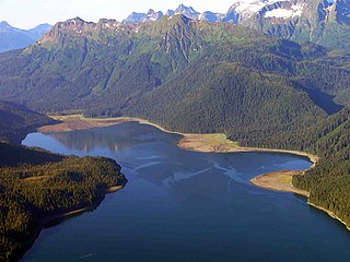
Baranof Lake is a glacially-fed, horseshoe-shaped lake on the eastern side of Baranof Island, in Alaska. Baranof Lake borders the community of Baranof Warm Springs and also has a Forest Service cabin on the northwestern end of the lake. Baranof River flows into the lake's western end and exits on the eastern end in rapids and a waterfall.

<span class="mw-page-title-main">Baranof River</span> River in the United States of America

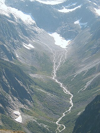
Baranof River is a glacially-fed river on the eastern side of Baranof Island, in the Alexander Archipelago, in the Alaska Panhandle. The source of the river is the unnamed icefields surrounding Peak 5390. Baranof River feeds into Baranof Lake, and the outlet of Baranof Lake that feeds into Warm Springs Bay is also commonly referred to as Baranof River as well.

<span class="mw-page-title-main">Medvejie Lake</span> Lake in the state of Alaska, United States

Medvejie Lake is a long, narrow, snow-fed lake on Baranof Island just south of Sitka, Alaska in the Alaskan Panhandle, which drains into Silver Bay, eight miles (13 km) southeast of Sitka, on west coast of Baranof Island, Alexander Archipelago.

<span class="mw-page-title-main">Mount Bassie</span>

Mount Bassie is a large mountain in the center of Baranof Island, Alaska, United States, within the City and Borough of Sitka.

<span class="mw-page-title-main">Blue Lake (Alaska)</span> Lake in the state of Alaska, United States

Blue Lake is a 3 miles (4.8 km) long reservoir located 6 miles (9.7 km) east of the town of Sitka, on the west side of Baranof Island, in the Alexander Archipelago of Southeast Alaska.

<span class="mw-page-title-main">Warm Springs Bay</span>

Warm Springs Bay is a 2.4 mile-long bay located just outside the small community of Baranof Warm Springs on Baranof Island in the Alexander Archipelago, Alaska. Warm Springs Bay receives the outflow of Baranof Lake and Baranof River. Warm Springs Bay is located at 57°04′49″N134°48′12″W.

Mount Furuhelm is a 3,620 foot peak located on Baranof Island just east and adjacent to Peak 5390 in Alaska. It is located at 57°03′00″N134°55′47″W.

Port Walter is located on the southeastern side of Baranof Island in Sitka City and Borough, Alaska. It is made up of two parts: Little Port Walter and Big Port Walter.

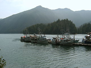
Silver Bay, or Gaǥeit', in the Tlingit language, is a deep water fjord located southeast of Sitka, Alaska, United States, that indents Baranof Island. It was named through a United States Coast and Geodetic Survey translation of Bukhta Serebryanikova, a name published first by Captain Tebenkov of the Imperial Russian Navy in 1852.

Partofshikof Island is an island in the Alexander Archipelago of southeastern Alaska, United States. It is part of the City and Borough of Sitka, and lies between the northern part of Kruzof Island and the northwestern part of Baranof Island. It is separated from Kruzof Island by Sukoi Inlet, and separated from Baranof Island by Neva Strait. Partofshikof Island has a land area of 34.177 km2 and no resident population.

Catherine Island is an island in the Alexander Archipelago of southeastern Alaska, United States. It is part of the City and Borough of Sitka and lies just off the northeast corner of Baranof Island, separated from it by Portage Arm. The U.S. Forest Service named Catherine Island in 1935 after Catherine I of Russia. Catherine Island has a land area of 86.936 km2 and no resident population.

Baranov is a Russian surname.

<span class="mw-page-title-main">Baranof Island</span> Island in southeastern Alaska, United States

Baranof Island is an island in the northern Alexander Archipelago in the Alaska Panhandle, in Alaska. The name "Baranof" was given to the island in 1805 by Imperial Russian Navy captain U. F. Lisianski in honor of Alexander Andreyevich Baranov. It was called Sheet’-ká X'áat'l by the native Tlingit people. It is the smallest of the ABC islands of Alaska. The indigenous group native to the island, the Tlingit, named the island Shee Atika. Baranof island is home to a diverse ecosystem, which made it a prime location for the fur trading company, the Russian American Company. Russian occupation in Baranof Island impacted not only the indigenous population as well as the ecology of the island, but also led to the United States' current ownership over the land.

<span class="mw-page-title-main">Baranof Warm Springs (thermal mineral springs)</span> Thermal spring

Baranof Warm Springs are a series of ten geothermal mineral springs located in the small community of Baranof Warm Springs in Sitka, Alaska. The springs are surrounded by the Tongass National Forest.

References

  1. 1 2 Orth, Donald J. (1967). Dictionary of Alaska Place Names, Geological Survey, Professional Paper 567. Washington: United States Government Printing Office.
  2. Soward, Kenneth S. (1961). "Geology of Waterpower Sites in Alaska: Geologic Investigations of Proposed Powersites at Baranof and Carbon Lakes, Baranof Island, Alaska" (Geological Survey Bulletin 1031 - B). United States Government Printing Office.
  3. Kirchoff, M. J. (1990). Baranof Island: An Illustrated History. Juneau: Alaska Cedar Press. ISBN   0-9624904-0-7.
  4. "U.S. Decennial Census". Census.gov. Retrieved June 6, 2013.
  5. "Population - Alaska" (PDF). United States Census Bureau. 1930.
  6. "Alaska - Number of Inhabitants" (PDF). United States Census Bureau. 1940.
  7. "Our Story". Alaska Whale Foundation. Archived from the original on 31 December 2014. Retrieved 31 December 2014.

57°05′22″N134°49′59″W / 57.08944°N 134.83306°W / 57.08944; -134.83306