
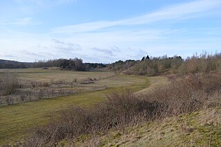
Wormley-Hoddesdonpark Wood North is a 143.9-hectare (356-acre) woodland area in Hertfordshire which has been designated as a biological site of Special Scientific Interest. The site is listed as Grade 1 in A Nature Conservation Review, and is also designated a Special Area of Conservation. It is in Hoddesdon in the borough of Broxbourne, but part of the site is in East Hertfordshire.

Herts and Middlesex Wildlife Trust manages over 40 nature reserves covering nearly 810 hectares north of London, in Hertfordshire and the historic county of Middlesex, part of which is divided between the London boroughs of Barnet, Enfield, Harrow and Hillingdon. It has over 21,000 members, and is one of 46 Wildlife Trusts across the UK. It is a Registered Charity, with its Registered Office in St Albans, and had an income in the year to 31 March 2014 of over £1.5 million.

Rye Meads is a 58.5-hectare (145-acre) biological Site of Special Scientific Interest (SSSI) in Rye House, Hoddesdon, Hertfordshire. It is one of series of wetlands and reservoirs situated along the River Lea, to the north-east of London. It is part of the Lea Valley Ramsar site and a Special Protection Area.

Stocker's Lake is an old flooded gravel pit of approx 90 acres (37.5ha) at Rickmansworth, Hertfordshire, England, within the Colne Valley Regional Park which is designated as a Local Nature Reserve.

Amwell Quarry or Amwell Nature Reserve is a 37 hectare biological Site of Special Scientific Interest in Great Amwell in Hertfordshire. The planning authority is East Hertfordshire District Council. It is also part of the Lee Valley Ramsar Site and Special Protection Area, and is owned and managed by the Hertfordshire and Middlesex Wildlife Trust.

Hunsdon Mead is a 34 hectare biological Site of Special Scientific Interest (SSSI) west of Harlow and east of Roydon in Essex. The site is partly in Essex and partly in Hertfordshire, and it is jointly owned and managed by the Essex Wildlife Trust and the Herts and Middlesex Wildlife Trust. The SSSI also includes part of the neighbouring Roydon Mead. The planning authorities are East Hertfordshire District Council and Epping Forest District Council. Hunsdon Mead is registered common land.

Sawbridgeworth Marsh is a 6.3-hectare (16-acre) biological Site of Special Scientific Interest (SSSI) near Sawbridgeworth in Hertfordshire, apart from a small area in the north which is in Essex. It is managed by the Essex Wildlife Trust. The planning authorities are East Hertfordshire District Council and Uttlesford District Council.
Waterford Heath is a 35.2 hectare Local Nature Reserve in Waterford in Hertfordshire, England. It is owned by Lafarge Tarmac and managed by the Herts and Middlesex Wildlife Trust together with East Hertfordshire District Council and Lafarge.

Hertford Heath nature reserve is a 28 hectare biological Site of Special Scientific Interest in Hertford Heath in Hertfordshire. It is managed by the Herts and Middlesex Wildlife Trust and the local planning authority is East Hertfordshire District Council.

Fox Covert is a 2.9-hectare (7.2-acre) nature reserve near Royston in North Hertfordshire. It is owned and managed by the Herts and Middlesex Wildlife Trust.

Pryor's Wood is an 8.7-hectare (21-acre) nature reserve in Great Ashby, near Stevenage in Hertfordshire. It was formerly managed by the Herts and Middlesex Wildlife Trust (HMWT). In February 2016 HMWT announced that three sites, Barkway Chalk Pit, Hill End Pit and Pryor's Wood, which HMWT managed on behalf of their owner, North Hertfordshire District Council, were to return to Council management as the Trust was no longer able to meet the cost.
Hill End Pit is a 0.7-hectare (1.7-acre) nature reserve on the site of a former chalk pit, in St Paul's Walden in North Hertfordshire. It was formerly managed by the Herts and Middlesex Wildlife Trust (HMWT). In February 2016 HMWT announced that three sites, Barkway Chalk Pit, Hill End Pit and Pryor's Wood, which HMWT managed on behalf of their owner, North Hertfordshire District Council, were to return to Council management as the Trust was no longer able to meet the cost. It has the largest colony of Azeca goodalli snails in Hertfordshire. Plants include viper's bugloss, cowslip and marjoram, there are butterflies such as common blue and gatekeeper, and many birds including woodpeckers.

Hexton Chalk Pit is a 1.9-hectare (4.7-acre) nature reserve in Hexton in North Hertfordshire, managed by the Herts and Middlesex Wildlife Trust. It is grassland with steep slopes and many chalk-loving plants such as horseshoe vetch, yellow-wort, milkwort and rockrose. There are five species of orchid and a large colony of chalkhill blue butterflies. The site has extensive views over the countryside.

Oughton Nature Reserve in Hitchin in Hertfordshire is managed by the Herts and Middlesex Wildlife Trust. The 6.2-hectare site on the north bank of the River Oughton is not publicly accessible, but it can be viewed across the river from Oughtonhead Common.

Long Deans is a 15 hectare nature reserve managed by the Herts and Middlesex Wildlife Trust in Nash Mills, between Kings Langley and Hemel Hempstead in Hertfordshire. It is neutral and chalk grassland and woodland with beech, ash, oak and wild cherry. Birds include common linnet, common bullfinch and song thrush, and the site is home to bats.

Ashwell Quarry and Quarry Springs is a three hectare nature reserve managed by the Herts and Middlesex Wildlife Trust near Ashwell in Hertfordshire. Ashwell Quarry is owned by a local farmer, and Quarry Springs by Hertfordshire County Council. It is a Regionally Important Geological Site.
