
The Icknield Way is an ancient trackway in southern and eastern England that runs from Norfolk to Wiltshire. It follows the chalk escarpment that includes the Berkshire Downs and Chiltern Hills.
Ivinghoe Beacon is a prominent hill and landmark in Buckinghamshire, England, 233 m (757 ft) above sea level in the Chiltern Hills, close to Ivinghoe and Aldbury. Dunstable, Berkhamsted and Tring are nearby.

The Chiltern Hills, a chalk escarpment in England northwest of London, covers 660 square miles (1,700 km2) across Oxfordshire, Buckinghamshire, Hertfordshire, and Bedfordshire, stretching 45 miles (72 km) from Goring-on-Thames in the southwest to Hitchin in the northeast. The hills are 12 miles (19 km) at their widest.

Dagnall is a village in the parish of Edlesborough, in Buckinghamshire, England.
Dunstable Downs are part of the Chiltern Hills, in southern Bedfordshire in England, located near the town of Dunstable. They are a chalk escarpment forming the north-eastern reaches of the Chilterns. At 243 m (797 ft), Dunstable Downs are the highest point in the county of Bedfordshire.

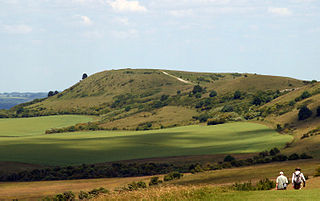
Pegsdon Hills and Hoo Bit is a 79-hectare (200-acre) nature reserve in Pegsdon in Bedfordshire. It is managed by the Wildlife Trust for Bedfordshire, Cambridgeshire and Northamptonshire. The site is on the border between Bedfordshire and Hertfordshire, and it covers Pegsdon Hills and part of the adjacent Deacon Hill in Bedfordshire, and Hoo Bit in Hertfordshire. It is in the Chilterns Area of Outstanding Natural Beauty, and part of the site is designated by Natural England as the Deacon Hill SSSI.

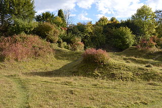
Totternhoe Knolls is a 13.1-hectare (32-acre) Site of Special Scientific Interest (SSSI) in Totternhoe in Bedfordshire. It is also a local nature reserve, and part of the Chilterns Area of Outstanding Natural Beauty. The site is owned by Central Bedfordshire Council and leased to the National Trust. Most of the site is maintained jointly by the National Trust and the Wildlife Trust for Bedfordshire, Cambridgeshire and Northamptonshire (WTBCN), and is part of the WTBCN Totternhoe nature reserve, which also includes Totternhoe Chalk Quarry and Totternhoe Stone Pit. The SSSI also includes Totternhoe Castle, the earthworks of a Norman motte-and-bailey castle which is a Scheduled monument.

Totternhoe Chalk Quarry is a 13.4-hectare (33-acre) biological Site of Special Scientific Interest in Totternhoe in Bedfordshire. Part of it lies in Totternhoe nature reserve, which is managed by the Wildlife Trust for Bedfordshire, Cambridgeshire and Northamptonshire. The site is part of the Chilterns Area of Outstanding Natural Beauty.
The Chiltern Way is a waymarked long-distance footpath in the Chiltern Hills of southern England. It was created by the Chiltern Society as a Millennium project.
Deacon Hill SSSI is a 35.4-hectare (87-acre) biological Site of Special Scientific Interest in Pegsdon in Bedfordshire. It is in the Chilterns Area of Outstanding Natural Beauty, and it is part of the Pegsdon Hills and Hoo Bit nature reserve, managed by Wildlife Trust for Bedfordshire, Cambridgeshire and Northamptonshire.
Knocking Hoe is a 7.7 hectare National Nature Reserve and biological Site of Special Scientific Interest near Pegsdon in Bedfordshire. It is mentioned in A Nature Conservation Review. It is part of the Chilterns Area of Outstanding Natural Beauty, and is managed by Natural England.

Barton Hills are situated southeast of the village of Barton-le-Clay in the English county of Bedfordshire. They are part of the Chilterns and hiking routes are marked on maps at the entrance to the hills. From the foot of the hillside, a spring marks the start of a chalk stream river. During the summer, Dartmoor ponies roam the hills.

Frogmore Meadows is a 4.6-hectare (11-acre) biological Site of Special Scientific Interest in Hertfordshire and Buckinghamshire, north of the village of Chenies. It consists of two meadows in the Chilterns Area of Outstanding Natural Beauty, next to the River Chess, one of which is a Hertfordshire and Middlesex Wildlife Trust nature reserve. The planning authorities are Three Rivers District Council, Dacorum Borough Council and Chiltern District Council.

Roughdown Common is a 3.6-hectare (8.9-acre) biological Site of Special Scientific Interest in Hemel Hempstead in Hertfordshire. The planning authority is Dacorum Borough Council. The site is Common land, and it is owned by the Box Moor Trust having been officially brought by the trust in April 1886 from the Dean and Chapter of St Paul's. It is part of the Chilterns Area of Outstanding Natural Beauty. The Common is a steeply sloping chalk hill in south Hemel Hempstead.

Weston Hills is a 17 hectare Local Nature Reserve in Baldock in North Hertfordshire. It is owned by Hertfordshire County Council and North Hertfordshire District Council (NHDC) and managed by NHDC.

Smithcombe, Sharpenhoe and Sundon Hills is an 86.1-hectare (213-acre) Site of Special Scientific Interest in Sharpenhoe in Bedfordshire. Most of it is a National Trust property comprising Sundon Hills, Moleskin and Markham Hills, Sharpenhoe Clappers and Smithcombe Hills. It is part of the Chilterns Area of Outstanding Natural Beauty, and Sharpenhoe Clappers is protected as a Scheduled Ancient Monument.

Ivinghoe Hills is a 210.4 hectares Site of Special Scientific Interest in Ivinghoe in Buckinghamshire, and part of the Chilterns Area of Outstanding Natural Beauty. It is listed in A Nature Conservation Review. The Ridgeway long-distance footpath ends and the Icknield Way Path starts in the site on Ivinghoe Beacon. An Iron Age fort on Ivinghoe Beacon and a tumulus on Gallows Hill are Scheduled Monuments. The site is part of the National Trust's Ashridge Estate, apart from a small area which belongs to Buckinghamshire County Council.

College Lake is a 65 hectare nature reserve in a former chalk quarry in Pitstone in the Aylesbury Vale district of Buckinghamshire. It is one of the flagship reserves of the Berkshire, Buckinghamshire and Oxfordshire Wildlife Trust, and it has an information centre, education facilities, a café, toilets and a shop. It is in the Chilterns Area of Outstanding Natural Beauty. The area east of the lake is a geological Site of Special Scientific Interest called Pitstone Quarry.
Aston Clinton Ragpits is a 2.9-hectare (7.2-acre) biological Site of Special Scientific Interest in Aston Clinton in Buckinghamshire. It is a former chalk quarry, which is now a nature reserve managed by the Berkshire, Buckinghamshire and Oxfordshire Wildlife Trust. It is in the Chilterns Area of Outstanding Natural Beauty.
