Related Research Articles

Thurston Island is an ice-covered, glacially dissected island, 215 km (134 mi) long, 90 km (56 mi) wide and 15,700 km2 (6,062 sq mi) in area, lying a short way off the northwest end of Ellsworth Land, Antarctica. It is the third-largest island of Antarctica, after Alexander Island and Berkner Island.

The Nimrod Glacier is a major glacier about 135 km (85 mi) long, flowing from the polar plateau in a northerly direction through the Transantarctic Mountains into the Ross Ice Shelf, Antarctica.

The Byrd Glacier is a major glacier in Antarctica, about 136 km (85 mi) long and 24 km (15 mi) wide. It drains an extensive area of the Antarctic plateau, and flows eastward to discharge into the Ross Ice Shelf.
The Churchill Mountains are a mountain range group of the Transantarctic Mountains System, located in the Ross Dependency region of Antarctica. They border on the western side of the Ross Ice Shelf, between Byrd Glacier and Nimrod Glacier.
Irvine Glacier is a glacier, 40 miles (64 km) long, draining southeast between the Guettard Range and the Rare Range into the northern part of Gardner Inlet, Antarctica. It was discovered by the Ronne Antarctic Research Expedition (RARE), 1947–48, under Finn Ronne, who named it for George J. Irvine, of the Engineer Depot at Fort Belvoir, Virginia, who outlined the RARE photographic program.

The David Glacier is a glacier over 60 nautical miles long, flowing east from the polar plateau through the Prince Albert Mountains to the coast of Victoria Land, Antarctica. It enters Ross Sea between Cape Philippi and Cape Reynolds to form the floating Drygalski Ice Tongue. It is the most imposing outlet glacier in Victoria Land. It is fed by two main flows which drain an area larger than 200,000 square kilometres, with an estimated ice discharge rate of 7.8 +/- 0.7 km³/year. The David Glacier was discovered by Ernest Shackleton's "Northern Party," in November 1908, under the leadership of Prof. T.W. Edgeworth David, of Sydney University, for whom the feature was named.
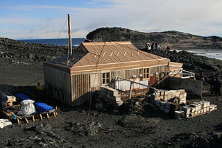
Cape Royds is a dark rock cape forming the western extremity of Ross Island, facing on McMurdo Sound, Antarctica. It was discovered by the British National Antarctic Expedition (BrNAE) (1901–1904) and named for Lieutenant Charles Royds, Royal Navy, who acted as meteorologist on the expedition. Royds subsequently rose to become an Admiral and was later Commissioner of the Metropolitan Police, London. This cape was the site of Shackleton's Hut, the expedition camp of the British Antarctic Expedition, 1907–09.
Michael Barne was an officer of the 1901-04 Discovery Expedition.
The Mulock Glacier is a large, heavily crevassed glacier which flows into the Ross Ice Shelf 40 kilometers south of the Skelton Glacier in the Ross Dependency, Antarctica.
New Bedford Inlet is a large pouch-shaped, ice-filled embayment between Cape Kidson and Cape Brooks, along the east coast of Palmer Land. Discovered and photographed from the air in December 1940 by members of the United States Antarctic Service (USAS), and named after New Bedford, Massachusetts, the centre of the New England whaling industry in the middle of the 19th century.
Noville Peninsula is a high ice-covered peninsula about 30 nautical miles (60 km) long, between Peale and Murphy Inlets on the north side of Thurston Island in Antarctica. It was delineated from aerial photographs made by U.S. Navy Operation HIGHJUMP in December 1946, and named for George O. Noville, executive officer of the Byrd Antarctic Expedition, 1933–35.

Nicholson Peninsula is a broad ice-covered peninsula about 15 nautical miles (28 km) long, between Couzens Bay and Matterson Inlet on the Shackleton Coast on the west side of the Ross Ice Shelf, Antarctica.
Eden Glacier is a glacier 5 nautical miles (9 km) long, which flows in a southerly direction into the head of Cabinet Inlet, northwest of Lyttelton Ridge, on the east coast of Graham Land. It was charted by the Falkland Islands Dependencies Survey (FIDS) and photographed from the air by the Ronne Antarctic Research Expedition in 1947. It was named by the FIDS for Rt. Hon. Robert Anthony Eden, M.P., then British Secretary of State for Foreign Affairs and member of the War Cabinet.
Evans Peninsula is an ice-covered peninsula about 30 nautical miles (60 km) long, between Koether Inlet and Cadwalader Inlet in the northeast part of Thurston Island. Cape Braathen is an ice-covered cape at the northwest termination of Evans Peninsula. It was discovered in flights from the USS Burton Island and USS Glacier by personnel of the U.S. Navy Bellingshausen Sea Expedition in February 1960, and was named by the Advisory Committee on Antarctic Names (US-ACAN) for Commander Griffith Evans, Jr., commander of the icebreaker Burton Island during this expedition.
Hansen Inlet is an ice-filled inlet between Cape Schlossbach and Cape Cox, along the east coast and near the base of the Antarctic Peninsula. It was mapped by the United States Geological Survey from ground surveys and U.S. Navy air photos, 1961–67, and was named by the Advisory Committee on Antarctic Names for B. Lyle Hansen who, with Herbert T. Ueda, was in charge of the deep-core drilling program at Byrd Station for several seasons, 1966–69.
Keller Inlet is an ice-filled inlet 12 nautical miles (22 km) long, in a northeast–southwest direction, and 6 nautical miles (11 km) wide, between Cape Little and Cape Fiske, along the east coast of Palmer Land, Antarctica. This inlet was photographed from the air by members of the United States Antarctic Service in December 1940, and in 1947 by members of the Ronne Antarctic Research Expedition under Finn Ronne, who in conjunction with the Falkland Islands Dependencies Survey charted it from the ground. It was amed by Ronne for Louis Keller of Beaumont, Texas, who contributed supplies to Ronne's expedition.
Rankin Glacier is a glacier about 12 nautical miles (22 km) long on the east side of Palmer Land. It flows southeast and then east along the south side of Schirmacher Massif to join the Cline Glacier just inland from the head of Odom Inlet. Mapped by United States Geological Survey (USGS) in 1974. Named by Advisory Committee on Antarctic Names (US-ACAN) for John S. Rankin, United States Antarctic Research Program (USARP) biologist on the International Weddell Sea Oceanographic Expeditions, 1968 and 1969.
Kerr Inlet is an ice-filled inlet, 1 nautical mile (2 km) wide, located at the west side of Cape Kerr in the northern part of Barne Inlet, Antarctica. It was named by the Advisory Committee on Antarctic Names in association with Cape Kerr.
Cape Kerr is a high snow-covered cape at the north side of Barne Inlet, the terminus of Byrd Glacier at the west side of the Ross Ice Shelf, Antarctica. It was discovered by the British National Antarctic Expedition (1901–1904) and named for Admiral of the Fleet, Lord Walter Kerr, one of the Sea Lords who lent his assistance to the expedition.
Lehrke Inlet is an ice-filled inlet, 15 kilometres (8 nmi) wide, which recedes southwest for 31 kilometres (17 nmi) between Cape Boggs and Cape Sharbonneau, along the east coast of Palmer Land, Antarctica. It was discovered by members of the United States Antarctic Service who explored this coast on land and from the air in 1940, and was named for Lester Lehrke, boatswain's mate of USS Bear, one of the expedition ships, and sailmaker of the East Base.
References
- ↑ "Barne Inlet". Geographic Names Information System . United States Geological Survey, United States Department of the Interior . Retrieved 2011-05-19.
![]() This article incorporates public domain material from "Barne Inlet". Geographic Names Information System . United States Geological Survey.
This article incorporates public domain material from "Barne Inlet". Geographic Names Information System . United States Geological Survey.
| | This Ross Dependency location article is a stub. You can help Wikipedia by expanding it. |