Barrabool Hills

Last updated

The Barrabool Hills are a small region in south-Western Victoria, on the western outskirts of Geelong. The National Trust of Australia describes the hills as being a "distinctive upland ridge located to the west of Geelong, on the south side of the Barwon River", that "slope steeply on the northern side down to the Barwon River, and more gently southward to the coastal lowland." [1] The area stretches roughly through the modern localities of Gnarwarre, Barrabool and Ceres, and straddles the intersection of the City of Greater Geelong, Surf Coast Shire and Golden Plains Shire.

Contents

History

The area was first settled by pastoralists in the late 1830s. [2] Wynd (1992) suggests that there was less conflict with the Wautharong traditional owners in the Barrabool Hills than further inland, but that incidents where settlers' animals were killed in the area sparked the 187 decision to send Foster Fyans as police sergeant to Geelong in 1837, followed by a thirteen-man military detachment in 1838. [3] An Aboriginal reserve was proposed for the Barrabool Parish in 1840, but the suggestion was ignored and the land sold. [4] The last member of the Barrabool tribe of the Wautharong died in 1885; Wynd attributes intertribal warfare, retaliation murders, disease, liquor, and the loss of their lands as causes of their demise [4]

The first road through the Barrabool Hills was surveyed by Alexander Skene in 1839, running from Highton through the "Roslin", "Merrawarp" and "Strathlachlan" estates to Winchelsea (then known as Austin's Ford). [5] The first sale of lands in the Barrabool Hills took place on 5 February 1840, when the lands of the Barrabool Parish, divided up into 25 blocks of varying sizes, were sold. Wynd writes that there was "plenty of competition for the rich lands of the Barrabool Hills". A sale of the Gnarwarre Parish in the west of the hills on 10 June 1840 was much less successful, with only four blocks being sold; the vast majority of that parish later sold during the 1850s. [6] Transport continued to be a significant challenge through this period, as the road between the hills and Geelong was of very low quality and was claimed to be "impassible" in winter. [7] The first community building in the region was an Anglican school at Barrabool in 1847, and Ceres became the first settlement in the hills when it was first built in 1850. [8] Throughout the 1850s, the village of Ceres prospered, and a smaller village at Gnarwarre (also known as Shankhill) developed; a number of churches and denominational schools were also built at Barrabool in this era, but a clear centre there never developed. [9] The Barrarbool Road District (note the spelling), the forerunner of the Shire of Barrabool, was created in 1853, and marked both an attempt to resolve the area's transport problems and its first local government. [10] The road board was later renamed "Barrabool Hills" by the 1850s. [11]

The Barrabool Hills became established as a farming area with the development of smaller farms in the late 1840s and 1850s, with a "reputation for fertility". [12] The 1850s, in addition to the local settlements, saw the development of local farms, including the Berramongo Estate and Suisse Vineyard at Barrabool, both of which still exist today. [13] However, the farmers of the Barrabool Hills also faced a number of difficulties throughout this period. The Barrabool Hills were badly burned in bushfires on 6 February 1851, which killed more than sixteen people. [14] Transporting wheat, the main crop of the hills in this era, to Geelong for milling proved a challenge, and a water mill was built on the Barwon River near Buckley Falls in 1854–55 to address this. [15] The development of roads continued to be a problem through the 1850s, with much local agitation for the development of key roads between the centres of the Barrabool Hills and the main roads, and for a bridge across the Barwon River, which first happened between Gnarwarre and Murgheboluc at Pollocksford in 1859, and then at Ceres in the 1860s. [16]

Vinegrowing

Vinegrowing in the Barrabool Hills had been ongoing since 1842, when the Neuchatel vineyard was established. The vineyard was successful, and Wynd suggests that by 1846 the only comparable vineyard in the Port Phillip colony was that of John Pascoe Fawkner in Melbourne. [17] The Berramongo property also planted a vineyard around 1842 or 1843. [18] The "Suisse" vineyard was established at the corner of Merrawarp Road and Barrabool Road in 1859. The "Victoria" was established near the Waurn Ponds Creek, the "Chillon", near the Neuchatel vineyard, and "Ceres" between Ceres and Highton, were among many to be established. [19] By 1863, Barrabool wine was selling well, and the Geelong Advertiser speculated that the area would become the "Victorian Halle aux Vins". At one stage, the Ceres-Barrabool area had 29 vineyards. [20] However, the industry declined in the 1870s, and a phylloxera vasiatrix outbreak, first detected in 1877, marked the end of the industry for many years. [21] Attempts to manage it failed, and by the end of 1882 the entire Geelong region was finished as a winegrowing region. There were small attempts to revitalise the industry in the 1880s and 1890s, but the industry did not return to the Barrabool Hills area until the 1970s. [22]

Self-governance and decline

The Barrabool Hills area gained full local government with the development of the Shire of Barrabool in 1865. [23] Two other short-lived organisations briefly existed in this era to address grievances held by local farmers: a Barrabool Hills Protection Association had been formed in May 1858 to grievances held by local farmers, and a Barrabool Hills Protection Association had been formed in May 1858 to support protectionist policies, and the Barrabool Farmers' Association formed in 1870 to address a range of issues with the authorities. [24] The number of people occupying land across the Shire of Barrabool declined substantially from the 1860s to the 1890s, as many settlers left the district and farm sizes once again became larger. [25] The wheat industry in the Barrabool Hills declined markedly, with farmers trying livestock and a variety of other crops as alternatives; it remained known as a farming district, and much of the district converted to selling hay. [26] While progress was made with a number of key road connections in around the Barrabool Hills through the 1870s and 1880s, the hills began to diminish in importance compared to lands further south. The development of railways through the area saw lines to the south and north of the Barrabool Hills, but no line in the hills region. [27] By the early 20th century, the Gnarwarre (or Shankill) village had largely shut down, the assortment of facilities at Barrabool was in decline, and the village of Ceres, while surviving, shrank considerably. [28]

Today

Gnarwarre and Barrabool remain sparsely-populated rural localities today; Ceres has seen a small increase in recent years due to its proximity to Geelong and scenic views.

A number of commercial and social developments in Highton, on the edge of the Barrabool Hills, have adopted the Barrabool Hills name in the 21st century. These include the Barrabool Hills Baptist Church, in Province Boulevard, and the Barrabool Hills Shopping Centre, currently being developed on the corner of Stoneleigh Crescent and Province Boulevard, Highton. [29] [30] [31]

Notes

  1. "Barrabool Hills". National Trust of Australia Classification. Heritage Victoria . Retrieved 12 July 2014.
  2. Wynd 1992, p. 9.
  3. Wynd 1992, p. 12.
  4. 1 2 Wynd 1992, p. 13.
  5. Wynd 1992, p. 124.
  6. Wynd 1992, p. 17.
  7. Wynd 1992, p. 123.
  8. Wynd 1992, pp. 65, 69.
  9. Wynd 1992, pp. 65–76.
  10. Wynd 1992, p. 125.
  11. Wynd 1992, p. 127.
  12. Wynd 1992, p. 25.
  13. Wynd 1992, p. 23.
  14. Wynd 1992, p. 35.
  15. Wynd 1992, p. 37.
  16. Wynd 1992, pp. 127–128, 133.
  17. Wynd 1992, pp. 51–52.
  18. Wynd 1992, p. 56.
  19. Wynd 1992, pp. 55–56.
  20. Wynd 1992, p. 59.
  21. Wynd 1992, pp. 59–60.
  22. Wynd 1992, pp. 61–63.
  23. Wynd 1992, p. 136.
  24. Wynd 1992, p. 39.
  25. Wynd 1992, p. 41.
  26. Wynd 1992, pp. 45, 49.
  27. Wynd 1992, pp. 140–151.
  28. Wynd 1992, pp. 67–69, 74, 76.
  29. Mathieson, Andrew (20 January 2011). ""Anger" at super plan". Geelong Independent. Archived from the original on 14 July 2014. Retrieved 12 July 2014.
  30. "Barrabool Hills Shopping Centre". realcommercial.com.au. Retrieved 12 July 2014.
  31. "Barrabool Hills Baptist Church". Archived from the original on 6 June 2014. Retrieved 12 July 2014.

Related Research Articles

<span class="mw-page-title-main">City of Greater Geelong</span> Local government area in Victoria, Australia

The City of Greater Geelong is a local government area in the Barwon South West region of Victoria, Australia, located in the western part of the state. It covers an area of 1,248 square kilometres (482 sq mi) and, had a population of 271,057 as of the 2021 Australian census. It is primarily urban with the vast majority of its population living in the Greater Geelong urban area, while other significant settlements within the LGA include Anakie, Balliang, Barwon Heads, Batesford, Ceres, Clifton Springs, Drysdale, Lara, Ocean Grove, Portarlington and St Leonards. It was formed in 1993 from the amalgamation of the Rural City of Bellarine, Shire of Corio, City of Geelong, City of Geelong West, City of Newtown, City of South Barwon, and parts of Shire of Barrabool and Shire of Bannockburn.

<span class="mw-page-title-main">Barwon River (Victoria)</span> Perennial river in Victoria, Australia

The Barwon River is a perennial river of the Corangamite catchment, located in The Otways and the Bellarine Peninsula regions of the Australian state of Victoria.

<span class="mw-page-title-main">Highton, Victoria</span> Suburb of Geelong, Victoria, Australia

Highton is a residential suburb of Geelong, Victoria, Australia. With views across Geelong, Corio Bay and the surrounding region, Highton is located along the banks of the Barwon River and across the rolling Barrabool Hills. The Barwon River straddles Highton to the north and east, while it is bordered by the hilly Ceres and Wandana Heights to the west, the former Kardinia Creek separates the suburb from Belmont to the south-east, and the Princes Highway and Pigdons Road to the south separate the suburb from Waurn Ponds.

<span class="mw-page-title-main">Belmont, Victoria</span> Suburb of Geelong, Victoria, Australia

Belmont is a southern suburb of Geelong, Victoria, Australia. The name means "beautiful hill". Belmont is geographically separated from the Geelong central business district by the Barwon River. The suburb is primarily residential, with some light industry along Barwon Heads Road. The suburb is part of the City of Greater Geelong local government area. At the 2011 census, Belmont had a population of 13,616.

<span class="mw-page-title-main">Bannockburn, Victoria</span> Town in Victoria, Australia

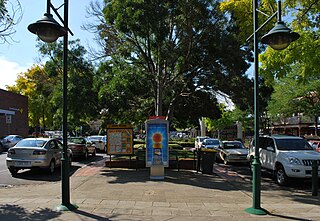
Bannockburn is a rural township near Geelong, Victoria, Australia, 88 km southwest of Melbourne. It is located in Golden Plains Shire. In the 2021 census, Bannockburn had a population of 6,470.

<span class="mw-page-title-main">Ceres, Victoria</span> Town in Victoria, Australia

Ceres is a locality of Geelong, Victoria, Australia. As one of the highest points in Geelong, Ceres has a lookout which overlooks the city. In the 2016 census, Ceres had a population of 254 people.

<span class="mw-page-title-main">Winchelsea, Victoria</span> Town in Victoria, Australia

Winchelsea is a town in Victoria, Australia. The town is located in the Surf Coast Shire local government area, the suburb or locality of Winchelsea is predominantly within Surf Coast Shire with a small section within the Colac Otway Shire. Winchelsea is located on the Barwon River 115 km south-west of Melbourne and close to Geelong.

<span class="mw-page-title-main">City of Geelong</span> Local government area in Victoria, Australia

The City of Geelong was a local government area about 75 kilometres (47 mi) southwest of Melbourne, the state capital of Victoria, Australia. The city covered an area of 13.4 square kilometres (5.2 sq mi), and existed from 1849 until 1993.

<span class="mw-page-title-main">Electoral district of South Barwon</span> State electoral district of Victoria, Australia

South Barwon is an electoral district of the Legislative Assembly in the Australian state of Victoria. Located in a mixed urban and rural area south of the Barwon River, it covers an area of 621 km², including the Geelong suburbs of Belmont and Grovedale, Waurn Ponds and part of Highton, the coastal centre of Torquay and the rural towns of Barrabool, Bellbrae, Connewarre, Gnarwarre, Modewarre, Moriac and Mount Moriac. The electorate had a population of 52,241 at the 2001 census.

Connewarre, is a locality in Victoria, Australia, is located in the City of Greater Geelong and Surf Coast Shire, and is named after Lake Connewarre which is situated immediately to its north-east. Connewarre is a version of "kunuwarra", the name of the black swan in the Wathawurrung language. At the 2016 census, Connewarre and the surrounding area had a population of 788.

<span class="mw-page-title-main">City of Geelong West</span> Local government area in Victoria, Australia

The City of Geelong West was a local government area about 5 kilometres (3 mi) west of the regional city of Geelong, Victoria, Australia. The city covered an area of 5.26 square kilometres (2.0 sq mi), and existed from 1875 until 1993.

<span class="mw-page-title-main">City of South Barwon</span> Local government area in Victoria, Australia

The City of South Barwon was a local government area in Victoria, Australia, which contained a number of Geelong suburbs south of the Barwon River, and extending to Torquay in the south and Barwon Heads to the east. The city covered an area of 165.4 square kilometres (63.9 sq mi), and existed from 1863 until 1994.

<span class="mw-page-title-main">Shire of Barrabool</span> Local government area in Victoria, Australia

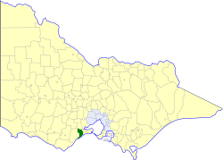
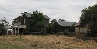
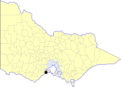
The Shire of Barrabool was a local government area about 100 kilometres (62 mi) southwest of Melbourne, the state capital of Victoria, Australia. The shire covered an area of 575.18 square kilometres (222.1 sq mi), and existed from 1853 until 1994.

<span class="mw-page-title-main">Rural City of Bellarine</span> Local government area in Victoria, Australia

The Rural City of Bellarine was a local government area southeast of the regional city of Geelong, Victoria, Australia, covering most of the Bellarine Peninsula. The Rural City covered an area of 331.78 square kilometres (128.1 sq mi), and from its origin as the Portarlington Road District, existed in a number of forms and under different names from 1853 until 1993.

<span class="mw-page-title-main">Shire of Corio</span> Local government area in Victoria, Australia

The Shire of Corio was a local government area located between Geelong and Werribee, about 60 kilometres (37 mi) southwest of Melbourne, the state capital of Victoria, Australia. The shire, which included all of Geelong's northern suburbs, covered an area of 704.66 square kilometres (272.1 sq mi), and existed from 1861 until 1993.

Mount Moriac is a rural locality in the Surf Coast Shire, Victoria, Australia. In the 2016 census, Mount Moriac had a population of 240 people.

Paraparap is a rural locality in the Surf Coast Shire, Victoria, Australia. At the 2016 census, Paraparap had a population of 151 people.

Gnarwarre is a rural locality in the Surf Coast Shire, Victoria, Australia. In the 1800s, the locality was alternately known as Shankhill. In the 2016 census, Gnarwarre had a population of 267 people.

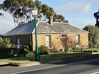
Barrabool is a rural locality in the Surf Coast Shire, Victoria, Australia. In the 2016 census, Barrabool had a population of 235 people.

References

Coordinates: 38°09′46″S144°16′03″E / 38.1629°S 144.2676°E / -38.1629; 144.2676