Bartine Hot Springs

Last updated

Bartine Hot Springs
Bartine Ranch Hot Springs
Ruby Hill historic town served by Fred Bartine's waterworks in 1878.jpg
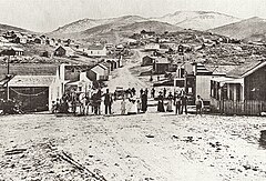
Ruby Hill historic mining town in 1878 served by Fred Bartine's waterworks
Coordinates 39°33′30″N116°21′40″W / 39.5583°N 116.36110°W / 39.5583; -116.36110 Coordinates: 39°33′30″N116°21′40″W / 39.5583°N 116.36110°W / 39.5583; -116.36110
Elevation6,102 feet
Type geothermal spring
Temperature102°F to 108°F / 39°C-42°C

Bartine Hot Springs also known as Bartine Ranch Hot Springs are geothermal hot springs located in the Antelope Valley of the Nevada high desert 40 kilometers northwest of the town of Eureka. [1]

Contents

History

The Bartine Ranch where the hot springs are located is named for Frederick "Fred" Bartine (1888-1964), who was born in Finland before immigrating to the U.S. to settle in Nevada in 1901. In addition to the ranch and hot springs, he owned the Ruby Hill Water Works, the Bartine Service Station, two mining claims. [2] [3] From 1924 to 1934, Bartine served as a Eureka County Commissioner. [4] Bartine developed 640 acres and drilled three artesian wells on this property. [5]

Location

The general physiographic area is in the intermontane plateaus of the Basin and Range Province of the Great Basin Desert. [6] [7] [8] The springs are located on a large tufa mound known as Hot Spring Hill surrounded by snow-capped mountains of the Monitor, Simpson Park and Mountain Boy ranges. [9] [8] A four-foot square concrete box has been built in the tufa mound as a soaking pool as well as a heart-shaped stone soaking pool. [9] [8] Bartine Warm Spring and a cold spring are located approximately 4 miles southeast of the hot springs. [1]

Water profile

There are four distinct hot spring sources on Hot Spring Hill. An artesian well is located approximately three miles away adjacent to the Bartine Ranch. [10] The hot mineral water emerges from the spring at a range of 102 °F to 108 °F. [7] [9]

See also

Related Research Articles

Great Artesian Basin Large Artesian aquifer in Australia

The Great Artesian Basin (GAB), located in Australia, is the largest and deepest artesian basin in the world, stretching over 1,700,000 square kilometres (660,000 sq mi), with measured water temperatures ranging from 30–100 °C (86–212 °F). The basin provides the only source of fresh water through much of inland Australia.

Geothermal areas of Yellowstone Geyser basins and other geothermal features in Yellowstone National Park

The geothermal areas of Yellowstone include several geyser basins in Yellowstone National Park as well as other geothermal features such as hot springs, mud pots, and fumaroles. The number of thermal features in Yellowstone is estimated at 10,000. A study that was completed in 2011 found that a total of 1,283 geysers have erupted in Yellowstone, 465 of which are active during an average year. These are distributed among nine geyser basins, with a few geysers found in smaller thermal areas throughout the Park. The number of geysers in each geyser basin are as follows: Upper Geyser Basin (410), Midway Geyser Basin (59), Lower Geyser Basin (283), Norris Geyser Basin (193), West Thumb Geyser Basin (84), Gibbon Geyser Basin (24), Lone Star Geyser Basin (21), Shoshone Geyser Basin (107), Heart Lake Geyser Basin (69), other areas (33). Although famous large geysers like Old Faithful are part of the total, most of Yellowstone's geysers are small, erupting to only a foot or two. The hydrothermal system that supplies the geysers with hot water sits within an ancient active caldera. Many of the thermal features in Yellowstone build up sinter, geyserite, or travertine deposits around and within them.

Mammoth Hot Springs Hot spring complex in Yellowstone National Park, Park County, Wyoming, U.S.

Mammoth Hot Springs is a large complex of hot springs on a hill of travertine in Yellowstone National Park adjacent to Fort Yellowstone and the Mammoth Hot Springs Historic District. It was created over thousands of years as hot water from the spring cooled and deposited calcium carbonate. Because of the huge amount of geothermal vents, travertine flourishes. Although these springs lie outside the caldera boundary, their energy has been attributed to the same magmatic system that fuels other Yellowstone geothermal areas.

Black Rock Desert Northwest Nevada dry lake

The Black Rock Desert is a semi-arid region of lava beds and playa, or alkali flats, situated in the Black Rock Desert–High Rock Canyon Emigrant Trails National Conservation Area, a silt playa 100 miles (160 km) north of Reno, Nevada that encompasses more than 300,000 acres (120,000 ha) of land and contains more than 120 miles (200 km) of historic trails. It is in the northern Nevada section of the Great Basin with a lakebed that is a dry remnant of Pleistocene Lake Lahontan.

Beowawe, Nevada Unincorporated community in Nevada, United States

Beowawe is a small town, in Eureka County, Nevada, United States.

Saline Valley

Saline Valley is a large, deep, and arid graben, about 27 miles in length, in the northern Mojave Desert of California, a narrow, northwest–southeast-trending tectonic sink defined by fault-block mountains. Most of it became a part of Death Valley National Park when the park was expanded in 1994. This area had previously been administered by the BLM. It is located northwest of Death Valley proper, south of Eureka Valley, and east of the Owens Valley. The valley's lowest elevations are about 1,000 feet (300 m) and it lies in the rain shadow of the 14,000-foot (4,300 m) Sierra Nevada Range, plus the 11,000-foot (3,400 m) Inyo Mountains bordering the valley on the west.

Ash Springs, Nevada Unincorporated community in Nevada, United States

Ash Springs is a town in the Pahranagat Valley of Lincoln County, Nevada. The town's principal industry is ranching. Ash Springs is named for the desert ash trees growing nearby.

Truckee Meadows

The Truckee Meadows is a valley in Northern Nevada, named for the Truckee River, which collects and drains all water in the valley. Truckee Meadows is also colloquially used as a name for the Reno–Tahoe-Fernley CSA area, even though the metro area includes areas outside this valley.

Dianas Punchbowl Thermal spring

Diana's Punchbowl, also called the Devil's Cauldron, is a geothermal feature located on a small fault in Nye County, Nevada. The spring is exposed through a cup-shaped depression about 50 feet (15 m) in diameter at the top of a domelike hill of travertine about 600 feet (180 m) in diameter. Hot water in the pool of the bowl is about 30 feet below the rim.

Bowers Mansion United States historic place

The Bowers Mansion, located between Reno and Carson City, Nevada, was built in 1863 by Lemuel "Sandy" Bowers and his wife, Eilley Orrum Bowers, and is a prime example of the homes built in Nevada by the new millionaires of the Comstock Lode mining boom.

Soda Lakes Pair of alkaline lakes in maar volcano craters in Churchill County, Nevada

The Soda Lakes are two lakes located northwest of Fallon, Nevada. They occupy two basaltic maar volcano craters which may have erupted in the last 1500 years. The larger lake, called Soda Lake or Big Soda Lake, is somewhat elongated, stretching 2 kilometers (1.2 mi) in length. The smaller one, Little Soda Lake, is 200 meters (660 ft) across. Considered to be a single volcano, the combined craters are young enough that future activity can't be ruled out. A geothermal power plant is located on the northeast flank of the volcano.

Scovern Hot Springs, California Former settlement in California, United States

Scovern Hot Springs is a thermal spring system, and former settlement in the Kern River Valley of the Southern Sierra Nevada, in Kern County, California.

Sloquet Hot Springs Place in British Columbia, Canada

Sloquet Hot Springs is a hot spring 100 km (62 mi) south east of Pemberton and Whistler in British Columbia, Canada along the in-SHUCK-ch forest service road and is located in the traditional First Nations community of Xa'xtsa or Douglas First Nation in the community of Tipella, at 78.5 km (48.8 mi) along the in-SHUCK-ch forest service road.

The Basturs Lakes are two lakes located n the northern foothills of “Mont de Conques” and close to the villages of Basturs and Sant Romà d'Abella, belonging to the municipality of Isona and Conca Dellà, in Pallars Jussà, Lleida, Catalonia, Spain.

Gold Strike Hot Springs Thermal spring

Gold Strike Hot Springs, also known as Goldstrike Hot Springs, Nevada Hot Springs and Gold Strike Canyon Hot Springs are a group of hot mineral water springs near Hoover Dam on the Arizona/Nevada border near historic Boulder City.

Fish Lake Hot Well Thermal spring

Fish Lake Hot Well, also known as Fish Lake Hot Spring and Fish Lake Valley Hot Well is a geothermal hot spring in Nevada.

Crystal Springs hot springs Thermal spring

Crystal Springs hot springs is a system of geothermal springs and seeps near Ash Springs, located at the site of a ghost town, Crystal Springs, Nevada. Several marshes and springs are located along the White River.

Soldier Meadows hot spring system Hot spring system

Soldier Meadows hot spring system is a group of hot and warm springs near the town of Gerlach, Nevada.

References

  1. 1 2 Dellechaie, Frank. "A Thermal, Geological and Geochemical Study of Selected Geothermal Areas of Nevada and Eastern California" (PDF). AMAX Exploration. Retrieved 13 February 2021.
  2. M, Ben and Clio Admin. "Bartine Outhouse & Eureka & Palisade Railroad Car". Clio: Your Guide to History. Retrieved 13 February 2021.
  3. "Bartine Outhouse". Historical Marker Database. Retrieved 13 February 2021.
  4. "Eureka County Elected Officials" (PDF). Retrieved 13 February 2021.
  5. "Fred Bartine obituary". Reno Gazette-Journal. Retrieved 13 February 2021.
  6. "Bartine Hot Springs". Western Mining History. Retrieved 21 June 2020.
  7. 1 2 Berry, George W.; Grim, Paul J.; Ikelman, Joy A. (1980). Thermal Spring List for the United States. Boulder, Colorardo: National Oceanic and Atmospheric Administration.
  8. 1 2 3 Gersh-Young, Marjorie (2011). Hot Springs and Hot Pools in the Southwest. Santa Cruz, California: Aqua Thermal. p. 30. ISBN   978-1-890880-09-5.
  9. 1 2 3 Spillman, Benjamin (November 24, 2017). "Nevada is a hot springs hotbed, here's how and where to find the perfect soak". Reno Gazette-Journal. Retrieved 21 June 2020.
  10. "Bartine Ranch Quadrangle, Bartine Hot Springs" (PDF). University of Nevada, Reno. Retrieved 13 February 2021.