Lüneburg Heath is a large area of heath, geest, and woodland in the northeastern part of the state of Lower Saxony in northern Germany. It forms part of the hinterland for the cities of Hamburg, Hanover and Bremen and is named after the town of Lüneburg. Most of the area is a nature reserve. Northern Low Saxon is still widely spoken in the region.
Staffordshire Moorlands is a local government district in Staffordshire, England. Its council, Staffordshire Moorlands District Council, is based in Leek and is located between the city of Stoke-on-Trent and the Peak District National Park. The 2001 census recorded the population as 94,489.

The Hamme is a 48 km (30 mi) long river in Germany, Lower Saxony, north-east of Bremen. Its source is north of Osterholz-Scharmbeck. It flows through the moors north-east of Bremen called Teufelsmoor, and meets the river Wümme in Ritterhude. From this junction, the river is called Lesum. The Lesum flows into the river Weser in Bremen-Vegesack.

Ganderkesee is a municipality in Oldenburg district, in Lower Saxony, Germany.

Lohne (Oldenburg) is a town in the district of Vechta, in Lower Saxony, Germany. It is located approximately 8 km south-west of Vechta. The town lies on the A1 freeway between Bremen and Osnabrück.
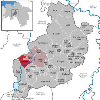
Rehden is a municipality in the district of Diepholz, in Lower Saxony, Germany. It is situated approximately eight km east of Diepholz.
Geest is a type of landform, slightly raised above the surrounding countryside, that occurs on the plains of Northern Germany, the Northern Netherlands and Denmark. It is a landscape of sandy and gravelly soils formed as a glacial outwash plain and now usually mantled by a heathland vegetation on the glacial deposits left behind after the last ice age during the Pleistocene epoch.
Drebber is a municipality in the district of Diepholz, in Lower Saxony, Germany.
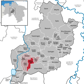
Hemsloh is a municipality in the district of Diepholz, in Lower Saxony, Germany.

Wetschen is a municipality in the district of Diepholz, in Lower Saxony, Germany.

Lezay is a commune in the Deux-Sèvres department in western France.

The North German Plain or Northern Lowland is one of the major geographical regions of Germany. It is the German part of the North European Plain. The region is bounded by the coasts of the North Sea and the Baltic Sea to the north, Germany's Central Uplands to the south, by the Netherlands to the west and Poland to the east.

The Bundesstraße 214 is a federal road that runs from Lingen to Brunswick in North Germany.
The Burgdorf-Peine Geest is a geest landscape, dominated by end and ground moraines, between Hanover and Brunswick in North Germany, with an area of about 550 square kilometres (210 sq mi). Its natural borders are the Aller depression in the north, the Hildesheim Börde and, in places, the Mittelland Canal in the south the Oker valley in the east and the Hanoverian Moor Geest in the west.

The Hanoverian Moor Geest is a gently rolling landscape between Hanover and Nienburg in the German state of Lower Saxony covering an area of around 800 square kilometres (310 sq mi). It belongs to the raised bog regions of northwest Germany, which cover the geest terrain formed during the ice age and which stretch from the Netherlands to the eastern border of Lower Saxony. The geest tract on the Hanoverian Moor Geest consists of a ground moraine plateau with a height of 50–85 metres (164–279 ft) above sea level that is dominated by bog. Its natural boundaries are the Aller glacial valley to the north and the Burgdorf-Peine Geest to the east.
The Wildeshausen Geest is part of the northwest Germany's geest ridge, that begins near Meppen on the river Ems with the Hümmling, is broken by the Weser depression, continues with the Osterholz Geest and reaches the marshes of Kehdingen by the river Elbe with the ridges of the Wingst and Stade Geest. It gives its name to the eponymous nature park.

The Hütten Hills are an area of upland, up to 105.8 m above sea level (NHN), roughly west of the town of Eckernförde in the county of Rendsburg-Eckernförde in the North German state of Schleswig-Holstein. They lie within the Hütten Hills Nature Park.

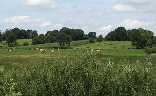
The nature reserve of Rehden Geest Moor is an extensive, open raised bog in the collective municipality of Rehden, in the county of Diepholz in Lower Saxony. It is a representative raised bog for the natural region known as the Diepholz Moor Depression. According to GIS it covers an area of 1,736 hectares, but according to the conservation act, 1,786 hectares.

The Großes Moor is the proper name for a contiguous region of raised bog between the towns of Damme, Lohne and Vechta and the village of Goldenstedt in the county of Vechta on the one hand, and the villages of Diepholz and Barnstorf in Diepholz and Bramsche in Osnabrück in Lower Saxony on the other, all within Germany.

The Peak District Boundary Walk is a circular 190-mile (310 km) walking trail, starting and finishing at Buxton and broadly following the boundary of the Peak District, Britain's first national park. The route was developed by the Friends of the Peak District and was launched on 17 June 2017.