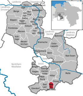
Hilter is a municipality in the district Osnabrück, Lower Saxony, Germany. It is located in the hills of the Teutoburg Forest.

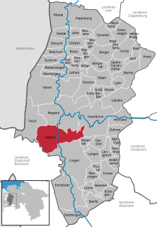
Bramsche is a town in the district of Osnabrück, Lower Saxony, Germany. It is about 20 kilometres north of Osnabrück, at 52°24′N7°59′E. Population is 30,952 (2018).

Laatzen is a town in the district of Hanover, in Lower Saxony, Germany. It is situated directly south of Hanover.
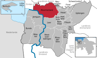
Moormerland is a municipality in the Leer District, in Lower Saxony, northwestern Germany.

Adendorf is a municipality in the district of Lüneburg, in Lower Saxony, Germany.
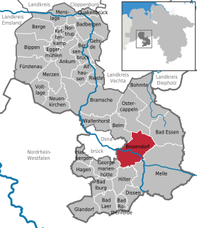
Bissendorf is a municipality in the district of Osnabrück, in Lower Saxony, Germany. It is situated approximately 9 km southeast of Osnabrück. Population 14,700 (2020).
Geeste is a municipality in the district Emsland in Lower Saxony.

Sulingen is a town in the district of Diepholz, Lower Saxony, Germany. It is situated approximatively 30 km east of Diepholz, and 45 km south of Bremen.

Emsbüren is a municipality in the Emsland district, Lower Saxony, Germany. It is situated on the river Ems, approx. 15 km south of Lingen, and 15 km northwest of Rheine.
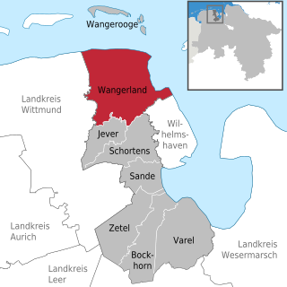
Wangerland is a municipality in the district of Friesland, Lower Saxony, Germany. It is situated on the North Sea coast, approximately 20 km northwest of Wilhelmshaven, and 10 km north of Jever. Its seat is in the village Hohenkirchen.

Rosdorf is a municipality in the district of Göttingen, in Lower Saxony, Germany. approx. 4 km southwest of Göttingen.

Steyerberg is a municipality in the district of Nienburg, in Lower Saxony, Germany. It is situated approximately 15 km southwest of Nienburg, and 30 km north of Minden.

Dötlingen is a municipality in the district of Oldenburg, in Lower Saxony, Germany. It is situated approximately 6 km northeast of Wildeshausen, and 25 km southeast of Oldenburg at the Hunte river. It's one of Germany's richest villages. The Nazis gave Dötlingen the title "Musterdorf von Deutschland", which means "Best village in Germany". In Dötlingen are many stone graves, and some plants and animals only exist there. Dötlingen was two times "Schönstes Dorf Deutschlands", the most beautiful village of Germany. Even if it is a beautiful place, Dötlingen is not known very much and has even in German language a very strange name. The oak tree in the middle of Dötlingen, next to the old church made of cobble stone, is over 1000 years old. The oak tree was struck by lightning and burst, but it survived.
Bad Rothenfelde is a municipality and health resort in the district of Osnabrück, in Lower Saxony, Germany.

Hagen is a municipality in the district of Osnabrück, in Lower Saxony, Germany. It is situated in the Teutoburg Forest, approx. 10 km southwest of Osnabrück.
Bad Lauterberg is a town in the district of Göttingen, in Lower Saxony, Germany. It is situated in the southern Harz, approx. 15 km southwest of Braunlage, and 20 km southeast of Osterode am Harz.

Obernkirchen is a town in the district of Schaumburg, in Lower Saxony, Germany. It is situated approximately 8 km southwest of Stadthagen, and 15 km east of Minden.

Hemmingen is a town in the district of Hanover, in Lower Saxony, Germany. It is situated approximately 6 km south of Hanover.

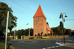
Brinkum is a municipality in the district of Leer, in Lower Saxony, Germany.

Geestland is a town in the district of Cuxhaven, in Lower Saxony, Germany. It was formed on 1 January 2015 by the merger of the former municipalities of Langen bei Bremerhaven, Bad Bederkesa, Drangstedt, Elmlohe, Flögeln, Köhlen, Kührstedt, Lintig and Ringstedt.