
The Maritsa, Meriç or Evros is, with a length of 480 km (300 mi), the longest river that runs solely in the interior of the Balkans. Its drainage area is about 53,000 km2 (20,000 sq mi), of which 66.2% in Bulgaria, 27.5% in Turkey and 6.3% in Greece. It has its origin in the Rila Mountains in Western Bulgaria, flowing southeast between the Balkan and Rhodope Mountains, past Plovdiv and Parvomay to Edirne, Turkey. East of Svilengrad, Bulgaria, the river flows eastwards, forming the border between Bulgaria and Greece, and then between Turkey and Greece. At Edirne, the river flows through Turkish territory on both banks, then turns towards the south and forms the border between Greece on the west bank and Turkey on the east bank to the Aegean Sea. Turkey was given a small sector on the west bank opposite the city of Edirne. The river enters the Aegean Sea near Enez, where it forms a river delta. The Tundzha is its chief tributary; the Arda is another one. The lower course of the Maritsa/Evros forms part of the Bulgarian-Greek border and most of the Greek–Turkish border. The upper Maritsa valley is a principal east-west route in Bulgaria. The unnavigable river is used for power production and irrigation.
Smolyan is a town and ski resort in the far south of Bulgaria near the border with Greece. It is the administrative and industrial centre of the homonymous Smolyan Province. The town is situated in the valley of the Cherna ("Black") and the Byala ("White") Rivers in the central Rhodopes at the foot of the mountains' highest part south of the popular ski resorts Pamporovo and Chepelare. As of February 2011, it has a population of 30,283 inhabitants.
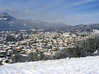
Zlatograd is a town in Smolyan Province, Southern-central Bulgaria. It is the administrative centre of the homonymous Zlatograd Municipality. In December 2009, the town had a population of 7,110.

Aytos, sometimes written Aitos and Ajtos, is a town located in eastern Bulgaria some 30 kilometers from the Bulgarian Black Sea Coast and belonging to the administrative boundaries of Burgas Province. It is the administrative centre of the homonymous Aytos Municipality. As of December 2009, the town has a population of 21,067 inhabitants.
Kàrlovo is a picturesque and a historically important town in central Bulgaria located in a fertile valley along the river Stryama at the southern foot of the Balkan Mountains. It is administratively part of Plovdiv Province and has a population of about 30,340, the mayor being Dr. Emil Kabaivanov.

The Timok, sometimes also known as Great Timok, is a river in eastern Serbia, a right tributary of the Danube. For the last 15 km of its run it forms a border between eastern Serbia and western Bulgaria.

Gugutka is a village in southernmost Bulgaria, part of Ivaylovgrad municipality, Haskovo Province. Located in the valley of the Byala Reka, it is famous for the Byalgrad medieval fortress located eight kilometres from the village. Its former name was "Arnavutköy".

Poduyane or Poduene (Подуене) is a residential complex and a district of Sofia, the capital of Bulgaria with 85,996 inhabitants. It is located in the eastern outskirts of the city and is divided into microregions. Poduyane consists of the neighbourhoods Suhata Reka, Hadzhi Dimitar, Poduyane, Stefan Karadzha, Levski, Levski-G, Levski-V. A former village, it was incoroparted in 1895. The district's holiday is celebrated on 1 June.

Primorsko is a town and seaside resort in southeastern Bulgaria, part of Burgas Province. A well-known resort on the Bulgarian Black Sea Coast, it is located on a gore 52 km south of Burgas and has a beach strip of about 1 km². The average temperature is 29 °C in July, often reaching 30-33 °C and making Primorsko a favourable place for tourism. Sea temperature in July and August is 27-28 °C. Primorsko enjoys more than 2300 sunshine hours a year, mostly in summertime. The rivers Ropotamo and Dyavolska reka run close to the town. The Ropotamo nature reserve and Snake Island reserve are also nearby.

The Jerma or Erma is a river in southeastern Serbia and western Bulgaria. Though not very long (72 km), it is notable for passing the Serbian-Bulgarian border twice.

The Rezovo is a river in the extreme southeast of Bulgaria and northernmost part of (European) Turkey. The river is situated in Bulgaria's Strandzha Nature Park.

The Erythropotamos or Luda reka is a river in southern Bulgaria and northeastern Greece. Its Turkish name was Kızıldelisu. Its source is near Mega Dereio. It flows into the Maritsa (Evros) near Didymoteicho.
Chereshovska Reka is a village in the municipality of Smolyan, located in the Smolyan Province of southern Bulgaria. The village is located 171.46 km from Sofia. As of 2007, the village had a population of 15 people.

The Ivanja Reka interchange is a cloverleaf interchange east of Zagreb, Croatia. The interchange represents the southern terminus of the A4 motorway and it connects the A4 route to the A3 motorway representing major a link in the Croatian motorway system. The interchange is a part of Pan-European corridors Vb and X. It also represents a junction of European routes E65, E70 and E71.
Byala Reka is a village in the municipality of Varbitsa, located in the Shumen Province of northeastern Bulgaria. The village covers an area of 65.85 square kilometres (25.42 sq mi) and is located 283.452 kilometres (176.129 mi) from Sofia. As of 2007, the village had a population of 1167 people.

Stara Reka is one of the nine nature reserves in the Central Balkan National Park in central Bulgaria. Stara Reka was established on 19 March 1981 to protect the unique ecosystems of the Balkan Mountains. It spans an area of 1974.7 hectares, or 19.747km2.


