
Opaka is a town in Targovishte Province in northeast Bulgaria. As of December 2009, the town had a population of 2,873. It covers an area of 57 square kilometres (22 sq mi). It is 70 kilometres (43 mi) south of the city of Rousse on the border with Romania and 250 kilometres (160 mi) northeast of the Bulgarian capital, Sofia. Archeologists have found evidence of Thracian, Roman and Slavonic settlements in the area. Near the village of Krepcha, a stone monastery is the site of the oldest known Old Bulgarian Cyrillic inscription, dated from around 920 CE. A 2nd century Thracian tumulus containing various artifacts, including six leaves of a golden wreath and bronze figurines, was excavated in 2011.
Zlatitsa is a town and the seat of the Zlatitsa Municipality in southern Bulgaria located in the Zlatitsa–Pirdop Valley. It lies between Stara Planina to the north and Sredna Gora to the south, at 680 metres (2,230 ft) above sea level. It is situated immediately south in the lap of the Zlatitsa-Teteven mountain. Zlatitsa is situated 75 kilometres (47 mi) east of Sofia, 27 kilometres (17 mi) south of Etropole, 32 kilometres (20 mi) north of Panagiurishte, 2 kilometres (1.2 mi) west of Pirdop, and 32 kilometres (20 mi) northwest of Koprivshtitsa. The population is 5,286.
Drygalski Glacier is a broad glacier, 18 nautical miles long which flows southeast from Herbert Plateau through a rectangular re-entrant to a point immediately north of Sentinel Nunatak on the east coast of Graham Land, Antarctica.
Sabine Glacier is a glacier terminating at the sea between Wennersgaard Point and Cape Kater on the northwest coast of Graham Land, Antarctica.
Gulyantsi is a town in central northern Bulgaria, part of Pleven Province. It is the administrative centre of Gulyantsi municipality and lies in the central north of the province, near the town of Nikopol, very close to the Danube River. As of December 2009, the town had a population of 3,432.

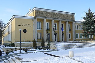
Sungurlare is a town in southeastern Bulgaria, part of Burgas Province. It is the administrative centre of Sungurlare municipality, which lies in the northwestern part of Burgas Province.

Kocherinovo is a town in southwestern Bulgaria, part of Kyustendil Province. It is the administrative centre of Kocherinovo Municipality, which lies in the southern part of Kyustendil Province. As of 2013 it had 2,255 inhabitants.
Iskar is a town in central northern Bulgaria, part of Pleven Province. It is the administrative centre of Iskar Municipality, which lies in the western part of the Province. The town of Iskar is located in the central Danubian Plain, near the Iskar River, 18 kilometres from Knezha and 32 kilometres from the provincial capital of Pleven. As of December 2009, the town had a population of 3,622 inhabitants.
Zavet is a town in northeastern Bulgaria, part of Razgrad Province and located in the geographic region of Ludogorie. It is the administrative centre of the homonymous Zavet Municipality, which lies in the northern part of Razgrad Province. Zavet is situated in the western Ludogorie Plateau, 12 kilometres from Isperih and Kubrat, and 35 kilometres from Tutrakan and Razgrad.
Vetovo is a town in northeastern Bulgaria, part of Ruse Province. It is the administrative centre of Vetovo Municipality, which lies in the eastern part of the area, and ranks third in population in the province after Ruse and Byala. The town is located 40 kilometres away from the provincial capital, Ruse. As of December 2009, Vetovo had a population of 4,777.

Smyadovo is a town in eastern Bulgaria, part of Shumen Province. It is the administrative centre of the homonymous Smyadovo Municipality, which lies in the southeastern part of the province. As of December 2009, the town had a population of 4,036.
Dalgopol is a town in northeastern Bulgaria, part of Varna Province. It is the administrative centre of Dalgopol Municipality, which lies in the southwestern part of the Province. As of December 2009, the town had a population of 4,829.
Suvorovo (Bulgarian: Суворово, pronounced[soˈvɔrovo], is a town in northeastern Bulgaria, part of Varna Province. It is the administrative centre of the homonymous Suvorovo Municipality, which lies in the northwestern part of the Province. The town is located in the southwestern part of the Dobruja plateau, 34 kilometres northwest of the provincial capital of Varna, 56 kilometres southwest of Dobrich and 59 kilometres east of Shumen. As of March 2023, it had a population of 5,207.
Dimovo is a town in northwestern Bulgaria, part of Vidin Province. It is the administrative centre of the homonymous Dimovo Municipality, which lies in the eastern part of Vidin Province, 30 kilometres (19 mi) from Vidin at the Danube and 50 kilometres (31 mi) from Bregovo at the Timok River and the Serbian border. As of December 2009, Dimovo had a population of 1,211 inhabitants.
Gramada is a town in northwestern Bulgaria, part of Vidin Province. It is the administrative centre of the homonymous Gramada Municipality, which lies in the central part of Vidin Province. It is located in the western Danubian Plain, 30 kilometres (19 mi) from the provincial capital Vidin and 200 kilometres (120 mi) from Sofia. As of December 2009, the town had a population of 1,647.

Altimir Glacier is a 4.8-kilometre (3.0 mi) long and 5.5-kilometre (3.4 mi) wide glacier draining the north slopes of the Osterrieth Range on Anvers Island in the Palmer Archipelago, Antarctica. It flows northwards to enter Dalchev Cove in Fournier Bay east of Studena Point.

Arapya Glacier is the 11.4 kilometres (7.1 mi) long and 5 kilometres (3.1 mi) wide glacier on the east side of north-central Sentinel Range in Ellsworth Mountains, Antarctica, situated south of Young Glacier. It flows southwards along the west side of Barnes Ridge and east of Chapman Peak and joins Ellen Glacier southwest of Mount Besch.
Zavera Snowfield is the glacier extending 18 kilometres (11 mi) in a north-south direction and 16 kilometres (9.9 mi) in an east-west direction on southern Trinity Peninsula in Graham Land, Antarctica. It is located in the northeast foothills of Detroit Plateau, south of Diplock Glacier, north of Mount Wild and northeast of Kopito Ridge. It drains into Prince Gustav Channel in Weddell Sea. The glacier is named after the Bulgarian liberation uprising of ‘Velchova Zavera’ in 1835.
Desudava Glacier is the 15.5 kilometres (9.6 mi) long and 5 kilometres (3.1 mi) wide glacier on Nordenskjöld Coast in Graham Land, Antarctica situated south of Dinsmoor Glacier and east-northeast of Boryana Glacier.

The Bulgaria–Turkey border is a 513 km (319 mi) long international border between the Republic of Bulgaria and the Republic of Turkey. It was established by the Treaty of San Stefano in 1878 as an inner border within the Ottoman Empire between Adrianople Vilayet and the autonomous province of Eastern Rumelia. The current borders are defined by the Treaty of Constantinople (1913) and the Bulgarian–Ottoman convention (1915). The border was reaffirmed by the Treaty of Lausanne ten years later, though Bulgaria was not a party to the latter treaty as it had earlier ceded to Greece that part of its border with Turkey which was modified by the Bulgarian-Ottoman convention.

