
Thiruvaiyaru is a panchayat town in Thanjavur District in the Indian state of Tamil Nadu.
Nanjangud, officially known as Nanjanagudu, is a town in the Mysuru district of the Indian state of Karnataka. Nanjangud lies on the banks of the river Kapila, 23 km from the city of Mysore. Nanjangud is famous for the Srikanteshwara Temple located here. Nanjangud is also called Dakshina Kashi. This town is also famous for a type of banana grown in the region called the Nanjanagoodu rasabale. Nanjangud's local administrative unit was designated as a Municipal Committee in 2015 by including Devirammanahalli and Kallahalli village.

Sholinghappuram, currently shortened as sholinghur is a municipality under Sholinghur taluk in Ranipet District of Tamil Nadu, India. The town is famous in Tamil Nadu and other neighboring states for the Lakshmi Narasimha Swamy temple.
Arsikere is a city and taluka in the Hassan district in the state of Karnataka, India. It is the second largest city in Hassan district, demographically. Arsikere city municipal council consists of 35 wards. This region is known for its coconut production and is also called Kalpataru Nadu. Arsikere Junction is a major railway junction in the South Western Railway which links Mangalore and Mysore to North Karnataka and a central place for tourists who visit nearby places that do not have rail access, such as Belur, Halebidu and Shravanabelagola, Harnahalli, and Kodimata.

Batlagundu is a town in Nilakottai block in Dindigul district in the Madurai Region state of Tamil Nadu, India. The name Vetrilai kundru later transformed and changed to Vathalagundu. The town is the major gateway to Kodaikanal. Subramaniya Siva was a writer, Indian Freedom Fighter, and activist born in Batlagundu. Batlagundu is the fifth-largest town in the Dindigul district. The town is located in such a way connecting three main districts of South Tamil Nadu. Batlagundu has most of the voters in Nilakottai Constituency.
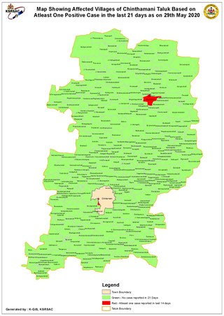
Chintamani is a Taluk Headquarters in the Indian state of Karnataka. Located on the Deccan Plateau in the south-eastern part of Karnataka. Chintamani is one of the well planned and developed Towns in the District of Kolar and presently Chikkaballapur. Chintamani is known for its silk and tomato production and their largest markets in Karnataka.

Madurantakam is the southernmost suburb of Chennai city and a municipality in Chengalpattu district in the Indian state of Tamil Nadu. The town is known for the artificial and second largest lake in Tamil Nadu, the Madurantakam lake. It is said to have been built by the Chola King Uttama Chola, also called as Maduranthaka, during his reign. It is also home to the Eri-Katha Ramar Temple. As of 2011, the town had a population of 30,796.
Pozhichalur is a census town in Chennai metropolitan city in the Indian state of Tamil Nadu. It is a suburb of Chennai and is located close to the Chennai Airport at Tirusulam on its south west side. It lies on the south banks of the Adyar River. Agasteeswarar Temple, which is called North Thirunallaru, is situated there. The neighborhood is served by Pallavaram Railway Station of the Chennai Suburban Railway Network. Pozhichalur will be part of Tambaram City Municipal Corporation.

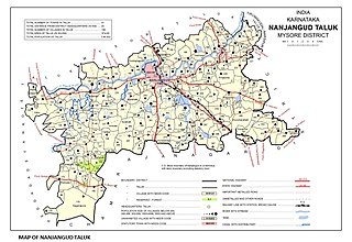
Tirumakudalu Narasipura the temple city of Karnataka, commonly known as T. Narasipura or T.N. Pura, is a town in Mysore district in the Indian state of Karnataka. The first name refers to the land at the confluence, (trimakuta in Sanskrit at the confluence of the Kaveri, Kabini and Spatika Sarovara. The city is a Taluk of Mysore district and 32 km south-east of the district headquarters and has five Hobli centers. This taluk is bordered by Chamarajanagar district to the south and Mandya districts to the north with an area of 598 sq km. Agriculture is the main occupation of the people here. Rice is the main food crop and silk is the main commercial crop. Fossils of Neolithic age have been found by excavation in some lands of this Taluk. Vyasatirtha, the guru of Purandara Dasa, and T Chowdiah, the unique violinist, were born in this Taluk. Talakad, the capital of the Western Ganga dynasty, is in this Taluk.
Budalur is a Town and Taluk in Thanjavur district of Tamil Nadu. There is a famous historic Shiva temple known as the Abathsagayeshwarar Temple situated in Budalur, built by Great Emperor Raja Raja Cholan during 10th century. This place is easy to access from, Thanjavur by 20 kilometers and Tiruchirapalli by 34 kilometers with both Railways and roadways.
Kallur is a village in the Gubbi subdistrict of the Tumkur district of Karnataka state in India. It has a Gram Panchayat. The village is located on the bank of the Shimsha river. It is mainly known for its handloom silk sarees. The handloom work is being performed traditionally, this work is transferred from their ancestors. The major caste in this village is Hindu Devanga and (lingayatha).

Vitla also Vittal is a town in Bantwal taluk of Dakshina Kannada district, India, around 18 km from Bantwal in Bantwal Taluk. It is also 14 km from Puttur and 40 km from Mangalore. Vitla was an assembly constituency of Karnataka Legislative Assembly, but discontinued from 2008 elections. Agriculture is the main occupation of people in and around Vitla town. Arecanut, cocoa, pepper, Cashew and coconut are grown here. There is a regional station of Central Plantation Crops Research Institute (CPCRI) which conducts research on areca nuts, an important commercial crop in the area. It also researches cocoa growing, including its production, protection and increasing drought resistance.
Naravi is a panchayat village in Belthangady taluk, Dakshina Kannada, in the foothills of the Western Ghats of India. There are two villages in the Naravi gram panchayat: Naravi and Kuthluru. It is 58 km from Mangalore and 25 km from Karkala towards Dharmasthala. Naravi is known for Sri Sooryanarayana temple, one of the two well known Sun temples, the other of which is at Konark. The village's name came from "Naa Ravi" in Kannada, which means no visible sunlight because of forest at daytime. It also has Sri Veenugopalakrishna Temple, which has a beautiful idol of Krishna carrying a child in his hands. Those who don't have children come to this statue of Krishna to pray for children.
Karekatte is a village in the Indian state of Karnataka. Karekatte is located on Davanagere-Nallur Sub division Channagiri connecting road. At a distance of about 34 km (21 mi) from the Davanagere (District). At a distance of about 28.6 km (18 mi) from the Channagiri (Taluk).
Saunshi is a village in the northern state of Karnataka, India. It is located in the Kundgol taluk of Dharwad district in Karnataka. largest gram Panchayat in Dharwad District.
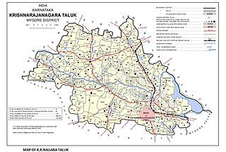
Saligrama is a new sub-district of Mysore district, situated on the northern bank of the river Cauvery [Kaveri]. This place is esteemed as sacred by the Shri Vaishnavas on account of its having been the residence of Sri Ramanujacharya. It is the headquarters of Saligrama Taluk. It was established as a new taluk carving out of K.R.Nagar taluk with effect from 31.12.2020 and become ninth taluk of Mysore district of Karnataka, India.
Patrame is a small, rural panchayat village on the left (east) bank of the Netravati River in Karnataka, India. Administratively, it is under Belthangady taluk, Dakshina Kannada district, Karnataka. Patrame is the only village in its gram panchayat. The village of Patrame is 26 km from its taluk headquarters Belthangady, and 8 km by road from Dharmasthala.

Kandamangalam (Tamil:கண்டமங்கலம்) is a town in Villupuram district, Villupuram taluk of Tamil Nadu. The town is one of the 13 panchayat unions in Villupuram district. The city falls under Vanur Assembly constituency and Viluppuram Lok Sabha constituency.
Nagaragere is a village in the southern state of Karnataka, India. It is located in the Gauribidanur taluk of Chikkaballapura district in Karnataka. It is situated 26 km away from sub-district headquarter Gauribidanur and 49 km away from district headquarter Chikkaballapura.
Hirebidanur is a village in the southern state of Karnataka, India. It is located in the Gauribidanur taluk of Chikkaballapura district in Karnataka. It is situated 2 km away from sub-district headquarters Gauribidanur and 33 km away from district headquarters Chikkaballapura.


