Batman's Hill

Last updated
Illustration depicting the changes to Batman's Hill between 1840 and 1892 Batmans hill 1840 and 1892.jpg
Illustration depicting the changes to Batman's Hill between 1840 and 1892
Looking south-west from the Collins Street Bridge towards the site of Batman's Hill in 2007. The blue post marking the hill can be seen to the left Batmans-hill-melbourne.jpg
Looking south-west from the Collins Street Bridge towards the site of Batman's Hill in 2007. The blue post marking the hill can be seen to the left

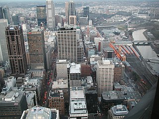
Batman's Hill in Melbourne, Australia was named for the Vandemonian adventurer and grazier John Batman. Now removed, the 18-metre-high [1] hill was located to the south of today's Collins Street and Southern Cross railway station, and is the site of a steel marker the same height as the original hill. [2]

The hill, on the traditional country of the Wurundjeri, was first claimed for John Fawkner by his representative Captain John Lancey of the Enterprize, who named it 'Pleasant Hill', and wrote to Fawkner in 1835,

Your lordship has been fortunate in the lot I chose for you. A more delightful spot, I think, cannot be. Beautiful grass, a pleasant prospect, a fine fresh-water river, and the vessel alongside the bank discharging at musket-shot distance from a pleasant hill where I intend to put your house. The garden will trend to the south by the east side of the hill ... The west side of the hill is a beautiful prospect. A salt lagoon and piece of marsh will make a beautiful meadow and bounded on the south by the river. The hill is composed of rich, black soil, thinly wooded with honeysuckle and she-oak. Good grass, a quantity of herbage that I cannot name more than three, viz., parsley of good flavour, peppermint, as good as any I ever tasted, and geraniums in abundance. [3]

In April 1836 the hill was settled by Batman and his family, who built a house at the base where Batman lived until his death in 1839. [4] His widow and family then moved from the house and the government requisitioned the house for government offices. [5]

In 1837, the Hoddle Grid, the first town plan was designed with Batman's Hill as its western boundary.

The hill had many other uses, in February 1839 it acted as a grandstand for Melbourne's first horse race, with the site later the site of navigation beacons, and a hospital. [5] Around the same time, Batman's Hill was also the site of the first cricket match played in Victoria by the founders of the Melbourne Cricket Club. [6] The western slope of Batman's Hill was sold to the government in 1847 and a powder magazine was built. At the foot of the slopes were tanning pits and melting works.

In 1853 the Victorian Government offered a concession to the Melbourne, Mount Alexander & Murray River Railway Company to build a railway from Melbourne to Echuca, including land to the east of Batman's Hill for the terminus. [5] In 1856 the company failed, [7] and was taken over by the government who formed the Victorian Railways to complete the works, the railway station being erected at Spencer Street in 1858. Growing traffic lead to an expansion of the freight sheds in 1863, with a contract being signed in November that year for the removal of the hill. Demolition was completed by the middle of 1866. [5] Further changes came with the construction of the No 2 Goods Shed, the Railways Headquarters Building in Spencer Street, Flinders Street Viaduct, Flinders Street Extension and the retaining wall just south of the goods yards in the 1880s and 90s. [8]

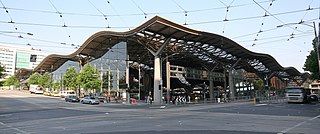
The site now forms the eastern border of the Docklands (a precinct of the Docklands development is also named Batman's Hill) and is dominated by Southern Cross station and the Collins Street bridge built in 2002 to replicate the original curve and shape of the hill. [9]

A significant portion of Batman's Hill is now being developed by the Walker Group as a commercial office precinct called Collins Square.

A 1920s hotel, the Batman's Hill Hotel was named after Batman's Hill.

Survey datum

Robert Hoddle's survey of the town of Melbourne in 1837. Batman's Hill-bottom left-is the datum Hoddle Map 1 1837.JPG
Robert Hoddle's survey of the town of Melbourne in 1837. Batman's Hillbottom leftis the datum

Robert Hoddle used Batman's Hill as the datum for the cadastral survey of the land around Melbourne from 1837. [10] A grid of orthogonal Section lines at one mile spacing, aligned with magnetic north, divided the land into one square mile (640 acre) sections for subdivision and land sales. The section boundaries were adjusted for watercourses. The linear property boundaries, in the absence of pre-existing tracks, were natural locations for major roads. For example:

Related Research Articles

<span class="mw-page-title-main">Southern Cross railway station</span> Melbourne railway station

Southern Cross railway station is a major railway station in Docklands, Melbourne. It is on Spencer Street, between Collins and La Trobe streets, at the western edge of the Melbourne central business district. The Docklands Stadium sports arena is 500 metres north-west of the station.

<span class="mw-page-title-main">Docklands, Victoria</span> Suburb of Melbourne, Victoria, Australia

Docklands, also known as Melbourne Docklands, is an inner-city suburb in Melbourne, Victoria, Australia, 2 km (1.2 mi) west of Melbourne's Central Business District, located within the City of Melbourne local government area. Docklands recorded a population of 15,495 at the 2021 census.

<span class="mw-page-title-main">Timeline of Melbourne history</span>

The following is a timeline of the history of the city of Melbourne, Victoria, Australia.

<span class="mw-page-title-main">Hoddle Grid</span> Layout of the Melbourne central business district

The Hoddle Grid is the contemporary name given to the approximately 1-by-0.5-mile grid of streets that form the Melbourne central business district, Australia. Bounded by Flinders Street, Spring Street, La Trobe Street, and Spencer Street, it lies at an angle to the rest of the Melbourne suburban grid, and so is easily recognisable. It is named after the surveyor Robert Hoddle, who marked it out in 1837, establishing the first formal town plan. This grid of streets, laid out when there were only a few hundred settlers, became the nucleus for what is now Melbourne, a city of over five million people.

<span class="mw-page-title-main">Clifton Hill, Victoria</span> Suburb of Melbourne, Victoria, Australia

Clifton Hill is an inner-city suburb in Melbourne, Victoria, Australia, 4 km (2.5 mi) north-east of Melbourne's Central Business District, located within the City of Yarra local government area. Clifton Hill recorded a population of 6,606 at the 2021 census.

<span class="mw-page-title-main">John Batman</span> Australian settler and explorer

John Batman was an Australian grazier, entrepreneur and explorer. He is best known for his role in the founding of Melbourne.

<span class="mw-page-title-main">Collins Street, Melbourne</span> Street in Melbourne, Victoria, Australia

Collins Street is a major street in the central business district of Melbourne, Victoria, Australia. It was laid out in the first survey of Melbourne, the original 1837 Hoddle Grid, and soon became the most desired address in the city. Collins Street was named after Lieutenant-Governor of Tasmania David Collins who led a group of settlers in establishing a short-lived settlement at Sorrento in 1803.

<span class="mw-page-title-main">Hoddle Highway</span> Highway in Melbourne, Victoria

Hoddle Highway is an urban highway in Melbourne linking CityLink and the Eastern Freeway, itself a sub-section of Hoddle Main Road. Both these names are not widely known to most drivers, as the entire allocation is still best known as by the names of its constituent parts: Hoddle Street, Punt Road and Barkly Street. This article will deal with the entire length of the corridor for sake of completion, as well to avoid confusion between declarations.

<span class="mw-page-title-main">Flinders Street, Melbourne</span> Street in Melbourne, Victoria

Flinders Street is a street in Melbourne, Victoria, Australia. Running roughly parallel to the Yarra River, Flinders Street forms the southern edge of the Hoddle Grid. It is exactly 1 mi (1.6 km) in length and one and a half chains in width.

<span class="mw-page-title-main">Spencer Street</span> Street in Melbourne, Victoria

Spencer Street is a major street and thoroughfare in the Melbourne central business district, Victoria, Australia. The street was gazetted in 1837 as the westernmost boundary of the Hoddle Grid.

<span class="mw-page-title-main">La Trobe Street</span> Street in Melbourne, Victoria

La Trobe Street is a major street and thoroughfare in the Melbourne central business district, Victoria, Australia. It runs roughly east–west and forms the northern boundary of the central business district. The street was laid out as an extension of the original Hoddle Grid in 1839 and was named after Charles La Trobe. La Trobe Street extends from Victoria Street in the east to Harbour Esplanade in the west.

<span class="mw-page-title-main">Victoria Street, Melbourne</span> Road in Melbourne, Victoria

Victoria Street is one of the major thoroughfares of inner Melbourne, running east–west for over six kilometres between Munster Terrace in North Melbourne and the Yarra River. The road is known as Victoria Parade for over one-and-a-half kilometres of its length, distinguishable with a wide reservation and tramway down the middle.

<span class="mw-page-title-main">Melbourne cable tramway system</span> Cable car public transport system in Melbourne, Australia

The Melbourne cable tramway system was a cable car public transport system, which operated between 1885 and 1940 in Melbourne, Victoria, Australia.

<span class="mw-page-title-main">Foundation of Melbourne</span> Forming of the city of Melbourne in Australia

The city of Melbourne was founded in 1835. The exact circumstances of the foundation of Melbourne, and the question of who should take credit, have long been matters of dispute.

<span class="mw-page-title-main">Melbourne central business district</span> Central business district of Melbourne, Victoria, Australia

The Melbourne central business district is the city centre and main urban area of the city of Melbourne, Victoria, Australia, centred on the Hoddle Grid, the oldest part of the city laid out in 1837, and includes its fringes. The Melbourne CBD is located mostly in the local government area of the City of Melbourne, which also includes some of inner suburbs adjoining the CBD, while a small section extends into the City of Port Phillip.

<span class="mw-page-title-main">Robert Russell (architect)</span> Australian architect (1808–1900)

Robert Russell was an architect and surveyor, active in Australia. He conducted the first survey of the site of the nascent settlement of Melbourne on the banks of the Yarra River in 1836, and designed St James Old Cathedral, the oldest building remaining in central Melbourne. He was also a prolific and talented artist and his work is held by major libraries and galleries in Australia.

North Melbourne Locomotive Depot was the main location for maintenance of the Victorian Railways steam locomotive fleet based in Melbourne. Located in the middle of the Melbourne Yard precinct in the suburb West Melbourne near North Melbourne station, the site is now occupied by the Melbourne Steel Terminal. The depot was described by railway employees as "the hub of the universe", "the VR's nearest approach to Dante's Inferno", or "the Black Hole of Calcutta" depending on their disposition.

<span class="mw-page-title-main">West Melbourne Swamp</span>

The West Melbourne Swamp also known as Batman's Swamp, was a large saltwater wetland located to the west of the city of Melbourne, Victoria. It was an important resource for Aboriginal people.

The Wailing Wall is a section of brick retaining wall on the Flinders Street Extension, Melbourne, which is famous as the place where Wharf labourers who missed out on the daily work call would congregate.

<span class="mw-page-title-main">No 2 Goods Shed</span>

No. 2 Goods Shed is a large railway freight shed in the former Spencer Street rail yards off Flinders Street Extension, Melbourne, Australia. It was constructed in 1889, originally called 'A Goods Shed', and at the time was the longest single building in Australia. Its address is at 733 Bourke Street, Docklands.

References

  1. Noè Harsel, Masters by research: The Shepherd Kings
  2. Society for Environmental Graphic Design - Merit Award: Melbourne Docklands Archived July 8, 2008, at the Wayback Machine
  3. cited in Greig, AW. 'Some new documentary evidence concerning the foundation of Melbourne'. Victorian Historical Journal 12, 1928, 114
  4. Australian Dictionary of Biography, Online Edition: Batman, John (1801 - 1839)
  5. 1 2 3 4 Sid Brown (November 2002). "Batman's Hill to Southern Cross - via Spencer Street". Newsrail : 335–347.
  6. MCC. "The first 50 years of the MCC". Alf Batchelder. Retrieved 2011-06-27.
  7. Australian Dictionary of Biography, Online Edition: Zeal, Sir William Austin (1830 - 1912)
  8. "Goods Shed No 2 OnMyDoorstep". Archived from the original on 2014-03-01. Retrieved 2013-10-11.
  9. Melbourne Docklands: Bridges (via Archive.org)
  10. Lay, Maxwell (2003). Melbourne Miles: The Story of Melbourne's Roads. Melbourne: Australian Scholarly Publishing. ISBN   1-74097-019-5.

37°49′12″S144°57′11″E / 37.82000°S 144.95306°E / -37.82000; 144.95306