Related Research Articles

Southern Cross railway station is a major railway station in Docklands, Melbourne. It is on Spencer Street, between Collins and La Trobe streets, at the western edge of the Melbourne central business district. The Docklands Stadium sports arena is 500 metres north-west of the station.

Docklands, is an inner-city suburb in Melbourne, Victoria, Australia on the western end of the central business district. Docklands had a population of 15,495 at the 2021 census.

The following is a timeline of the history of the city of Melbourne, Victoria, Australia.

Hawthorn railway station is a commuter railway station on the Alamein, Belgrave and Lilydale lines, which are all part of the Melbourne railway network. It serves the eastern suburb of Hawthorn, in Melbourne, Victoria, Australia. Hawthorn station is a ground level unstaffed station, featuring three platforms, an island platform with two faces and one side platform. It opened on 13 April 1861. The station is listed on the Victorian Heritage Register.

Flinders Street is a street in Melbourne, Victoria, Australia. Running roughly parallel to the Yarra River, Flinders Street forms the southern edge of the Hoddle Grid. It is exactly 1 mi (1.6 km) in length and one and a half chains in width.

Melbourne tram route 70 is operated by Yarra Trams on the Melbourne tram network from Waterfront City to Wattle Park. The 16.5 kilometre route is operated out of Camberwell depot with A and B class trams.
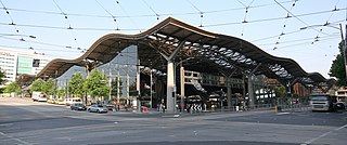
Spencer Street is a major street and thoroughfare in the Melbourne central business district, Victoria, Australia. The street was gazetted in 1837 as the westernmost boundary of the Hoddle Grid.

Station Pier is a historic Australian pier on Port Phillip, in Port Melbourne, Victoria. Opened in 1854, the pier is Melbourne's primary passenger terminal, servicing interstate ferries and cruise ships, and is listed on the Victorian Heritage Register.

West Melbourne is an inner-city suburb in Melbourne, Victoria, Australia, 2 km (1.2 mi) north-west of the Melbourne central business district, located within the City of Melbourne local government area. West Melbourne recorded a population of 8,025 at the 2021 census.

Batman's Hill in Melbourne, Australia was named for the Vandemonian adventurer and grazier John Batman. Now removed, the 18-metre-high hill was located to the south of today's Collins Street and Southern Cross railway station, and is the site of a steel marker the same height as the original hill.

The Banana Alley Vaults are near the Flinders Street station in Melbourne, Australia and extend onto the North Bank of the Yarra River.

Melbourne tram route 48 is operated by Yarra Trams on the Melbourne tram network from Balwyn North to Victoria Harbour. The 13.5-kilometre (8.4 mi) route is operated out of Kew depot with A and C class trams.

The Melbourne central business district is the city centre and main urban area of the city of Melbourne, Victoria, Australia, centred on the Hoddle Grid, the oldest part of the city laid out in 1837, and includes its fringes. The Melbourne CBD is located mostly in the local government area of the City of Melbourne, which also includes some of inner suburbs adjoining the CBD, while a small section extends into the City of Port Phillip.

The Charles Grimes Bridge is a dual-carriageway bridge that carries the Docklands Highway over the Yarra River in the Docklands precinct of Melbourne, Australia. It was named after New South Wales surveyor general Charles Grimes, who was the first European to see the Yarra River.
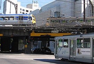
The Flinders Street Viaduct is a railway bridge in Melbourne, Australia. Made up of six tracks built at different times, it links Flinders Street station to Southern Cross station, forming the main connection between the eastern and western parts of the Victorian rail network.

Jolimont Yard was an array of railway lines and carriage sidings on the edge of the central business district of Melbourne, Australia. Located between Flinders Street station, Richmond Junction, the Yarra River and Flinders Street they were often criticised for cutting off the city from the river, being the site of many redevelopment proposals. The Princes Gate Towers were built over part of the yard in the 1960s, which themselves were replaced by Federation Square in the 2000s. The rail sidings themselves were progressively removed from the 1980s to the 1990s with only running lines today, but the area continues to be referred to as the 'Jolimont railyards' by Melburnians.

Batman Park is an urban park, located on the northern bank of the Yarra River in central Melbourne, Victoria, Australia.

Victoria Dock also known as Victoria Harbour is a large excavated harbour basin located off Footscray Road and Docklands Highway, Docklands, in Melbourne. It was constructed between 1887 and 1892, under the supervision of Melbourne Harbor Trust engineer Joseph Brady, to modified designs of British engineer Sir John Coode.

No. 2 Goods Shed is a large railway freight shed in the former Spencer Street rail yards off Flinders Street Extension, Melbourne, Australia. It was constructed in 1889, originally called 'A Goods Shed', and at the time was the longest single building in Australia. Its address is at 733 Bourke Street, Docklands.
The Melbourne tram network began in 1884 with the construction of the Fairfield Horse Tramway. However, the purpose of the line was to increase land prices in the area, and it soon closed during the depression in 1890. The first genuine attempt to construct a tramway network was the construction of the Richmond cable tram line by the Melbourne Tramway & Omnibus Company in 1885. Over the next few years, 16 more cable tram lines were constructed, as well as numerous other horse tramways. The depression of the early 1890s slowed further expansion of the cable network. The first electric tram line was the Box Hill and Doncaster tramway which opened in 1889. This was a pioneering line in what was then the countryside and thus didn't receive much patronage. It closed in 1896. The next attempt at an electric tramway was Victorian Railways' St Kilda to Brighton line, which opened in 1906. Later that year, the North Melbourne Electric Tramway & Lighting Company opened lines to Essendon and Maribyrnong. Many local councils formed their own tramway trusts and built tramways within their own constituency. The most successful of these was the Prahran & Malvern Tramways Trust.
References
- ↑ OnMyDoorStep 'Retaining Wall' Heritage 588-754 Flinders Street Extension Melbourne
- ↑ RETAINING WALL, Victorian Heritage Register (VHR) Number H0932
- ↑ Docklands Heritage Study: A Report to the Docklands Task Force, Andrew Ward, Peter Milner, Gary Vines and Ron Greenaway Docklands Task Force. Historic Buildings Council (Vic.) Jan 1, 1991
- ↑ 'Batmans Hill' eMelbourne encyclopaedia Published by School of Historical Studies Department of History, The University of Melbourne July 2008 Updated: 25 February 2010
- ↑ A History of Struggle on the Wharves, Sydney Trades Hall
- ↑ BATMAN'S HOUSE Victorian Heritage Inventory (HI) Number D7822-1958
- ↑ Image of pickup semicircle at Walsh Bay Sydney
- ↑ Robert Bollard, Victorian workers in the 1917 Mass Strike Australian National University
- ↑ "Flinders Street Extension Murder MYSTERIOUS MESSAGE TO POLICE". The Argus. Melbourne. 31 January 1947. p. 1. Retrieved 11 October 2013– via National Library of Australia.
- ↑ RETAINING WALL, Victorian Heritage Register (VHR) Number H0932
- ↑ 'Road Infrastructure at Docklands Now Complete' Melbourne Docklands Authority Friday, 15 September 2000