
The Union of the Peoples of Cameroon is a political party in Cameroon.
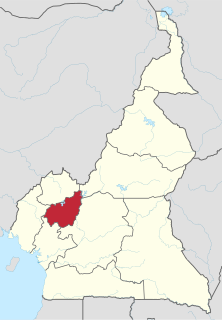
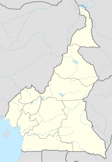
The West Region is 14,000 km² of territory located in the central-western portion of the Republic of Cameroon. It borders the Northwest Region to the northwest, the Adamawa Region to the northeast, the Centre Region to the southeast, the Littoral Region to the southwest, and the Southwest Region to the west. The West Region is the smallest of Cameroon's ten regions in area, yet it has the highest population density.

The Bamileke are a Grassfields people. They are the largest ethnic group in Cameroon and inhabit the country's West Region. The Bamileke are regrouped under several groups, each under the guidance of a chief or fon. They speak a number of related languages from the Eastern Grassfield branch of the GrassField language family. These languages are closely related, however, and some classifications identify a Bamileke dialect continuum with seventeen or more dialects. The Bamileke people are known for their very striking and often intricately beaded masquerades, including the impressive elephant mask.
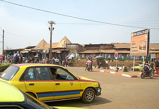
Bafoussam is the capital and largest city of the West Region of Cameroon, in the Bamboutos Mountains. It is the 3rd most important (financially) city in Cameroon, after Yaounde and Douala. The communauté urbaine of Bafoussam, is a decentralized territorial collectivity. Originally called Urban Commune of Bafoussam, the communauté urbaine of Bafoussam, was born after the Presidential Decree N ° 2008/022 of January 17, 2008 and composed of three communes, namely: the Commune of Bafoussam I, the Commune of Bafoussam II (Baleng) and the Commune of Bafoussam III (Bamougoum).
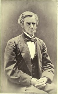
Alfred Saker was a British missionary of the London Baptist Missionary Society. In 1858 he led a Baptist Mission that relocated from the then Spanish island of Fernando Po and landed in Southern Cameroons. According to the record, he bought land from indigenous Bimbia chiefs, established a seaside settlement christened Victoria after the reigning British Empress. The settlement was renamed Limbe by decree in 1982 by President Ahmadou Ahidjo of Cameroun.
Bana is a sub-prefecture and commune in the West Province of Cameroon, some 8 km east of Bafang and 2 km south-west of Babouantou.
Bandjoun is a town and commune in the Koung-Khi Department in the West Region of Cameroon. Bandjoun is also the capital of the Koung-Khi department, and one of the largest traditional chiefdom (chefferie) in Bamiléké country. The chief dwells in Hialah, and has many wives.
Marie-Thérèse Assiga Ahanda was a Cameroonian novelist, chemist, and paramount chief of the Ewondo and Bene people. Early in life, Ahanda worked for the Chemistry Department of the University of Yaoundé. She later moved to the Republic of the Congo with her husband, Jean Baptiste Assiga Ahanda, and took to writing. When they returned to Cameroon, Ahanda became an elected delegate in the National Assembly of Cameroon, a position she held from 1983 to 1988. Ahanda became the Ewondo paramount chief in 1999. In December 2000, she began renovating her father's palace at Efoulan, Yaoundé, a project that cost an estimated 150,000,000 francs CFA. Ahanda is the daughter of Charles Atangana—paramount chief of the Ewondo and Bene peoples under the German and French colonial regimes—by his second wife, Julienne Ngonoa.

Sports in Cameroon is practiced widely by the population and advocated by the national government. Cameroonians take pride in victories at international competitions, making sport an important source of national unity. Traditional sports in Cameroon include canoe racing, swimming, tug of war, and wrestling. Wrestling has featured in the initiation rites and other ceremonies of ethnic groups such as the Bakweri and the Duala. However, in modern times, sports such as basketball, boxing, cycling, handball, netball, caber toss, and table tennis have become popular. The 40 km Mount Cameroon Race of Hope draws several hundred runners each year. Tourists hike, rock climb, and mountaineer, especially up Mount Cameroon. Yaoundé, Tiko and Kribi have golf courses. Rugby union is also played, with about 15 clubs and 3000 players nationally.
Claude Njiké-Bergeret is the grand daughter and daughter of the French Protestant missionaries Etienne Bergeret and Charles Bergeret which worked in the first half of the 20th century in the bamiléké area in Cameroon. She is the widow of the polygamic Bangangté chief Francois Njiké Pokam. She is also a book writer, farmer and community organiser near Foumbot.
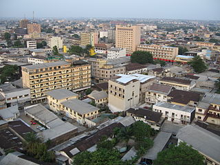
Douala is the largest city in Cameroon and its economic capital. It is also the capital of Cameroon's Littoral Region. Home to Central Africa's largest port and its major international airport, Douala International Airport (DLA), it is the commercial and economic capital of Cameroon and the entire CEMAC region comprising Gabon, Congo, Chad, Equatorial Guinea, Central African Republic and Cameroon. Consequently, it handles most of the country's major exports, such as oil, cocoa and coffee, timber, metals and fruits. As from 2018, the city and its surrounding area had an estimated population of 2,768,400. The city sits on the estuary of Wouri River and its climate is tropical.

NDE is one of the 58 divisions found in Cameroon. It is located in the western region of the Country, about 150km from Douala the economic capital and about 265 km from Yaoundé the political capital. Its estimated population is 304,800. There are two meanings that are attached to the acronym NDE. The first and most popular is Nobility, Dignity, Elegance. The second meaning is New, Deal, Economy. Bangangte has been the headquarter of the NDE division since June 14, 1961. Medumba is the most common language spoken in this region. Its kingdoms include; Bangangte, Bangoulap, Balengou, Bazou, Bakong, Bamena, Tonga (Badounga), Bahouoc, Bangang-Fokam, Bawock, Bangoua, Batchingou, Bamaha and Bagnoun. The main Religious belief is Christianity, with the two main denominations being Catholics and Protestant. Its climate ranges between 14- 22 Celsius at night and between 24-30 Celsius. Some anthropological research has been done by Pradelles de Latour.
Yabassi is a town and commune in western Cameroon, and capital of the Nkam department. Its population in 2001 was estimated at 12,000. The main dialect spoken is the Yabassi. However, there are also other dialects originating in the Nkam which are spoken.
Wabane is a town and council/commune in Cameroon. It is the headquarters of Wabane sub-division in Lebialem division Southwest Region of Cameroon.

French Cameroon or French Cameroons was a League of Nations Mandate territory in Central Africa. It now forms part of the independent country of Cameroon.
Tankeu Noé was a member of the Union of the Peoples of Cameroon (UPC) guerrilla forces in Cameroon fighting first against French colonial government and then against the government of Ahmadou Ahidjo in the Douala region.
The following is a timeline of the history of the city of Douala, Cameroon.

Tayap is a small village of Cameroon located in the Centre Region, between the country's capital Yaounde (86 km) and Douala (164 km). The village of Tayap is part of the Ngog-Mapubi district of the Nyong-et-Kéllé department.

Hervé Gabriel Ngamago Youmbi, born in Bangui on March 25, 1973, is a Cameroonian artist who lives and works in Douala. He is a founding member of the Cercle Kapsiki, a collective of five Cameroonian artists, founded in 1998.
Victor Fotso was a famous Cameroonian businessman. He was the founder of the Fotso Group of companies and his foundation, which carries out charitable works in Cameroon and other Sub-Saharan African countries, particularly in the field of education.
