
The North Kent Marshes are in the far north of the county of Kent spanning dry and wet south banks and inlets of the Thames Estuary in south-east England. The marshes are one of 22 Environmentally Sensitive Areas recognised by the UK's Department for Environment, Food and Rural Affairs (DEFRA). They are in the Thames Gateway regional planning area. They include the 5,289-hectare (20.4 sq mi) South Thames Estuary and Marshes biological SSSI.

The Swale is a tidal channel of the Thames estuary that separates the Isle of Sheppey from the rest of Kent. On its banks is a 6,509.4-hectare (16,085-acre) biological Site of Special Scientific Interest which stretches from Sittingbourne to Whitstable in Kent. It is also a Ramsar internationally important wetland site and a Special Protection Area under the European Union Directive on the Conservation of Wild Birds. Parts of it are a Nature Conservation Review site, Grade I, National Nature Reserves, a Kent Wildlife Trust nature reserve and a Local Nature Reserve.

Chiswick Eyot is a 3.266-acre (1.3 ha) narrow, uninhabited ait of the Thames. It is a tree- and reed-covered rise on the Tideway by Chiswick, in London, England and is overlooked by Chiswick Mall and by some of the Barnes riverside on the far bank.

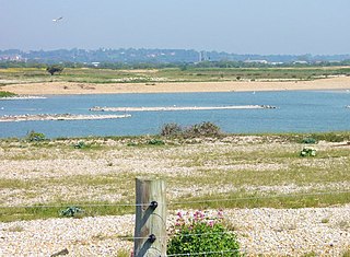
Oare Marshes is a 71.4-hectare (176-acre) Local Nature Reserve north of Faversham in Kent. It is owned and managed by Kent Wildlife Trust. It is part of The Swale Nature Conservation Review site, Grade I, National Nature Reserve, Ramsar internationally important wetland site, Special Protection Area under the European Union Directive on the Conservation of Wild Birds, and Site of Special Scientific Interest.

South Swale is a 410.5-hectare (1,014-acre) Local Nature Reserve north of Faversham in Kent. It is owned by Kent County Council and managed by Kent Wildlife Trust. It is part of The Swale Ramsar site, Special Protection Area and Site of Special Scientific Interest

Burham Marsh nature reserve is an 11 hectare tidal Reed bed on the River Medway 5 miles northwest of Maidstone. It is just east of Snodland but being on the east bank of the river it is accessed via Burham. It is part the Holborough to Wouldham Marshes Site of Special Scientific Interest.
Dungeness, Romney Marsh and Rye Bay is a 10,172.9-hectare (25,138-acre) biological and geological Site of Special Scientific Interest which stretches from New Romney in Kent to Winchelsea in East Sussex. An area of 5,129.5 hectares is a Special Protection Area, an area of 3,141.1 hectares is a Special Area of Conservation, and an area of 6,377.6 hectares is a Ramsar Site, a wetland site designated of international importance under the Ramsar Convention. Part of the site is in the High Weald Area of Outstanding Natural Beauty, parts are Geological Conservation Review sites, part is a Local Nature Reserve, and part is a Royal Society for the Protection of Birds nature reserve, and part is a National Nature Reserve.

Cranham Marsh is a 15.3 hectare Local Nature Reserve and a Site of Metropolitan Importance for Nature Conservation in Cranham in the London Borough of Havering. It is owned by Havering Council and managed by the Essex Wildlife Trust.

Crossness Nature Reserve is a 25.5 hectare local nature reserve in Crossness in the London Borough of Bexley. It is part of the Erith Marshes Site of Metropolitan Importance for Nature Conservation. The site is next to Crossness Sewage Works, and is owned and managed by Thames Water.
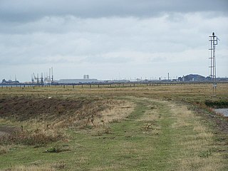
Medway Estuary and Marshes is a 4,748.8-hectare (11,735-acre) biological Site of Special Scientific Interest which stretches along the banks of the River Medway between Gillingham and Sheerness in Kent. It is a Nature Conservation Review site, Grade I, a Ramsar internationally important wetland site, and a Special Protection Area under the European Union Directive on the Conservation of Wild Birds.

South Thames Estuary and Marshes is a 5,289-hectare (13,070-acre) biological Site of Special Scientific Interest which stretches between Gravesend and the mouth of the River Medway in Kent. Part of it is a Nature Conservation Review site, Grade I, and part is a Royal Society for the Protection of Birds nature reserve. It is part of the Thames Estuary and Marshes Ramsar internationally important wetland site and Special Protection Area under the European Union Directive on the Conservation of Wild Birds.

Ambley Wood is a 14-hectare (35-acre) Local Nature Reserve in Gillingham in Kent. It is owned and managed by Medway Council.

Berengrave Chalk Pit is a 12.77-hectare (31.6-acre) Local Nature Reserve in Rainham in Kent. It is owned and managed by Medway Council.

Darland Banks is a 29.1-hectare (72-acre) Local Nature Reserve on the southern outskirts of Gillingham in Kent. It is owned by Medway Council and managed by Kent Wildlife Trust.

Prince's Beachlands is a 6-hectare (15-acre) Local Nature Reserve north of Sandwich in Kent. It is owned by Dover Town Council and managed by Kent Wildlife Trust as part of the Sandwich Bay to Hacklinge Marshes nature reserve. It is part of the Sandwich and Pegwell Bay Nature Conservation Review site, Grade I, Thanet Coast and Sandwich Bay Ramsar site, Sandwich Bay Special Area of Conservation, Thanet Coast and Sandwich Bay Special Protection Area and Sandwich Bay to Hacklinge Marshes Site of Special Scientific Interest.

Seasalter Levels is a 71.4-hectare (176-acre) Local Nature Reserve in Seasalter, on the western outskirts of Whitstable in Kent. It is owned and managed by Canterbury City Council. It is part of The Swale Ramsar site, Special Protection Area and Site of Special Scientific Interest.

South Wood is a 6.6-hectare (16-acre) Local Nature Reserve in Hempstead, south of Gillingham in Kent. It is owned and managed by Medway Council.
Vinters Valley Park is a 30.2-hectare (75-acre) Local Nature Reserve in Maidstone in Kent. It is owned by Kent County Council and Maidstone Borough Council and managed by the Vinters Valley Trust.

Foxburrow Wood is a 6.1-hectare (15-acre) Local Nature Reserve in Rainham in Kent. It is owned and managed by Medway Council.

