
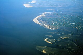
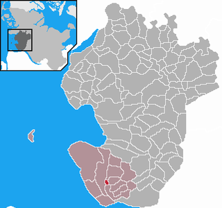
The Bay of Meldorf [1] [2] also called Meldorf Bay (German : Meldorfer Bucht), is a bay on the coast of the North German state of Schleswig-Holstein, which forms part of the Heligoland Bight.
The Bay of Meldorf [1] [2] also called Meldorf Bay (German : Meldorfer Bucht), is a bay on the coast of the North German state of Schleswig-Holstein, which forms part of the Heligoland Bight.
The bay lies about 90 km (as the crow flies) northwest of Hamburg and 30 km north-northeast of Cuxhaven. It falls within the district of Dithmarschen. To the north is the North Sea resort of Büsum, to the south the seaside resort of Friedrichskoog, which does not however border directly onto Meldorf Bay. To the east is the village of Hemmingstedt and the town of Meldorf, which gives the bay its name. To the west the bay opens out into the North Sea. Its most important channel is the Piep, which is up to 20 metres deep and divides in Meldorf Bay into three branches: the Wöhrdener Loch (north), the Kronenloch and the Sommerkoog-Steertloch (south).
As a result of several major storm floods in the late Middle Ages and early modern times, the bay expanded further and further into the low marshes and almost reached the town of Meldorf, sited on a geest ridge. Not until the 16th century was land reclaimed and the polders (Köge) within the bay dyked for the first time.
On 17 February 1500 the independent peasant republic of Dithmarschen fought the army of the King of Denmark and his brother at the Battle of Hemmingstedt. The king's cavalry, largely composed of nobles, was almost entirely drowned in the waters of the spring tide in Meldorf Bay.

When the last dykes were built from April 1969 to March 1978, taking in an area of about 8.5 x 8 kilometres, Meldorf Bay was left with an (estimated) area of 30 km². The construction of the latest dykes was not, however, primarily aimed at land reclamation but coastal defence. For example, by building new, 8.8 metre high dykes that were only 14.8 km long (in the core area of the bay), the crest of the dyke was raised significantly and the length of the dyke greatly shortened. The newly created Speicherkoog on Meldorf Bay is designed primarily to store water from the interior during inland flooding and to discharge it into the sea through two dyke sluices and scoop wheels. In addition, the salt marshes act as a protected sanctuary for birds. Agriculture only plays a minor role in Speicherkoog. Sheep are grazed here to help to stabilize the dykes. Both the Speicherkoog as well as the other undyked areas of Meldorf Bay belong to protection zone 1 of the Schleswig-Holstein Wadden Sea National Park and are therefore subject to special conservation laws.
In Meldorf Bay lies the uninhabited island of Helmsand, which is like one of the Halligen and many years ago was linked to the mainland by a causeway. It is also a bird reserve like the island of Trischen, which lies off the bay. Even the sandbanks of Blauort and Tertius may only be visited with special permission.
The immediate coastal areas are fully developed for tourism. The Norderpiep and Süderpiep channels provide access to the port of Büsum. The shrimp cutters stationed there fish Meldorf Bay as well as other areas. The southern part of the bay is used by the Bundeswehr as a weapons testing area. In the western part, just north of the Elbe estuary and the Vogelsand is a burial site for those buried at sea. [3]

Nordfriesland, also known as North Frisia, is the northernmost district of Germany, part of the state of Schleswig-Holstein. It includes almost all of traditional North Frisia, as well as adjacent parts of the Schleswig Geest to the east and Stapelholm to the south, and is bounded by the districts of Schleswig-Flensburg and Dithmarschen, the North Sea and the Danish county of South Jutland. The district is called Kreis Nordfriesland in German, Kreis Noordfreesland in Low German, Kris Nordfraschlönj in Mooring North Frisian, Kreis Nuurdfresklun in Fering North Frisian and Nordfrislands amt in Danish.

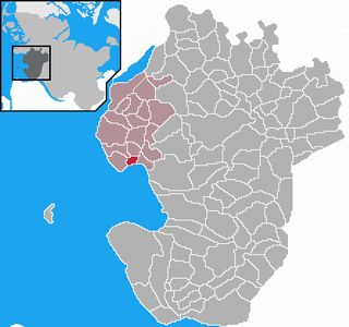
Dithmarschen is a district in Schleswig-Holstein, Germany. It is bounded by the districts of Nordfriesland, Schleswig-Flensburg, Rendsburg-Eckernförde, and Steinburg, by the state of Lower Saxony, and by the North Sea. From the 13th century up to 1559 Dithmarschen was an independent peasant republic within the Holy Roman Empire and a member of the Hanseatic League.
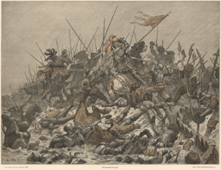
The Battle of Hemmingstedt took place on 17 February 1500 south of the village of Hemmingstedt, near the present village of Epenwöhrden, in the western part of present-day Schleswig-Holstein, Germany. It was an attempt by King John of Denmark and his brother Duke Frederick, who were co-dukes of Schleswig and Holstein, to subdue the peasantry of Dithmarschen, who had established a peasants' republic on the coast of the North Sea. John was at the time also king of the Kalmar Union.
The Schleswig-Holstein Wadden Sea National Park is a national park in the Schleswig-Holstein area of the German Wadden Sea. It was founded by the Parliament of Schleswig-Holstein on 1 October 1985 by the National Park Act of 22 July 1985 and expanded significantly in 1999. Together with the Lower Saxon Wadden Sea National Park, the Hamburg Wadden Sea National Park and those parts of Elbe estuary which are not nature reserves, it forms the German part of the Wadden Sea.

The Bay of Greifswald or Greifswald Bodden is a basin in the southwestern Baltic Sea, off the shores of Germany in the state of Mecklenburg-Vorpommern. With an area of 514 km², it is the largest Bodden of the German Baltic coast.

The Heligoland Bight, also known as Helgoland Bight, is a bay which forms the southern part of the German Bight, itself a bay of the North Sea, located at the mouth of the Elbe river. The Heligoland Bight extends from the mouth of the Elbe to the islands of Heligoland and lies between the East Frisian island of Wangerooge and the North Frisian peninsula of Eiderstedt.

Meldorf is a town in western Schleswig-Holstein, Germany, that straddles the river Miele in the district of Dithmarschen.

Büsum is a fishing and tourist town in the district of Dithmarschen, in Schleswig-Holstein, Germany. It is situated on the North Sea coast, approx. 18 km southwest of Heide.
Büsumer Deichhausen is a municipality belonging to the Amt Büsum-Wesselburen in the district Dithmarschen in Schleswig-Holstein, Germany.

Hedwigenkoog is a municipality belonging to the Amt Büsum-Wesselburen in the district Dithmarschen in Schleswig-Holstein, Germany.

Warwerort is a municipality in the Amt Büsum-Wesselburen in the district Dithmarschen in Schleswig-Holstein, Germany.
Westerdeichstrich is a municipality belonging to the Amt Büsum-Wesselburen in the district Dithmarschen in Schleswig-Holstein on the West Coast of Germany. It consists of the parts Westerdeichstrich, Groven, Augustenhof and Stinteck.
Marnerdeich is a municipality in the district of Dithmarschen, in Schleswig-Holstein, Germany.
Nordermeldorf is a borough in the district of Dithmarschen, in Schleswig-Holstein, Germany.

Blauort is one of Germany's uninhabited North Sea sandy islets off the coast of Dithmarschen, and measures about 1,200 m from north to south and 500 metres from east to west. It is surrounded by the sandbank of Blauortsand, which is bounded to the north by the creek of the Wesselburener Loch and to the south by the Piep.

is an uninhabited island in the Meldorf Bay, about 14 kilometres off the North Sea coast of Dithmarschen in north Germany – about 12 kilometres from the Trischendamm embankment. The island belongs to the municipality of Friedrichskoog and is only occupied from March to October by a bird warden from the Nature and Biodiversity Conservation Union or NABU. Otherwise it is out-of-bounds. Trischen originated about 400 years ago and moves about 3 m per month towards Büsum on the mainland.

Tourism is an important economic factor for Germany's northernmost state of Schleswig-Holstein.

Tertius is a sandbank located in the Heligoland Bight off the coast of Dithmarschen belonging to the German state of Schleswig-Holstein.

The Bay of Husum, Husum Bight or Husum Bay is a bay on the North Sea coast of the German state of Schleswig-Holstein. Its German name is used for marketing the holiday region around the town of Husum.
54°05′02″N8°53′10″E / 54.084°N 8.886°E
| International | |
|---|---|
| National | |