Arrowsmith Peninsula is a cape about 40 miles (64 km) long on the west coast of Graham Land, west of Forel Glacier, Sharp Glacier and Lallemand Fjord, and northwest of Bourgeois Fjord, with Hanusse Bay lying to the northwest. It was surveyed by the Falkland Islands Dependencies Survey (FIDS) in 1955-58 and named for Edwin Porter Arrowsmith, Governor of the Falkland Islands.
Barff Peninsula is a peninsula forming the east margin of Cumberland East Bay, South Georgia Island. It is 8 miles (13 km) long and extends northwest from Sörling Valley to Barff Point, its farthest extremity. It was probably first seen by the British expedition under James Cook in 1775. The peninsula as a whole takes its name from Barff Point, which was named for Royal Navy Lieutenant A.D. Barff of HMS Sappho, who, assisted by Captain C.A. Larsen, sketched a map of Cumberland Bay in 1906. Barff Point is considered the eastern headland of East Cumberland Bay.
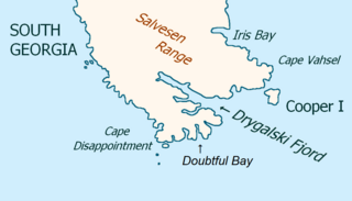
Drygalski Fjord is a bay 1 mile (1.6 km) wide which recedes northwestwards 7 miles (11 km), entered immediately north of Nattriss Head along the southeast coast of South Georgia. It was charted by the Second German Antarctic Expedition, 1911–12, under Wilhelm Filchner, and named for Professor Erich von Drygalski, the leader of the First German Antarctica Expedition, 1901–03.
Shoesmith Glacier is the largest glacier on Horseshoe Island, flowing westward into both Lystad Bay and Gaul Cove. Named by United Kingdom Antarctic Place-Names Committee (UK-APC) in 1958 in association with Horseshoe Island.

Prospect Point is a headland at the west extremity of Velingrad Peninsula on Graham Coast in Graham Land, nearly 2 nautical miles (3.7 km) south of Ferin Head and immediately east of the Fish Islands. Roughly charted by the British Graham Land Expedition (BGLE) under Rymill, 1934–37. Photographed by Hunting Aerosurveys Ltd. in 1956–57. The name was suggested in 1957 by E. P. Arrowsmith, Governor of the Falkland Islands.
Woodfield Channel is a deep water channel between the Dion Islands and Henkes and Rocca Islands, off the south end of Adelaide Island. Named by the United Kingdom Antarctic Place-Names Committee (UK-APC) in 1963 for Thomas Woodfield, First Officer of RRS Hydrographic Survey Unit in the survey of this area in 1963.

Bottrill Head is a rugged headland on the east side of Bourgeois Fjord which forms the southwest extremity of German Peninsula and the north side of the entrance to Dogs Leg Fjord in Fallières Coast, on the west side of Graham Land, Antarctica. It was first surveyed in 1936 by the British Graham Land Expedition (BGLE) under John Rymill. The headland was resurveyed in 1948 by the Falkland Islands Dependencies Survey (FIDS) who named it for Harold Bottrill, Chairman of the Board of Directors, later General Manager, of Maclean and Stapledon S.A., shipping agents at Montevideo, who gave great assistance to the BGLE, 1934–37, and to FIDS, 1943–48.

Norway Bight is a bay 4 nautical miles (7 km) wide indenting the south coast of Coronation Island between Meier Point and Mansfield Point, in the South Orkney Islands. The name appears on a chart by Petter Sorlle, Norwegian whaling captain who made a running survey of the South Orkney Islands in 1912–13.
Knuckle Reef is a reef lying off Beacon Head, Horseshoe Island, Antarctica. The reef was so named by the UK Antarctic Place-Names Committee in 1958 because the individual rocks in the reef, which are exposed at low tide, resemble the knuckles of a clenched fist.
Stride Peak is a peak rising to 675 m at the head of Dalgliesh Bay, Porquoi Pas Island, in Marguerite Bay. Named by United Kingdom Antarctic Place-Names Committee (UK-APC) in 1979 after Geoffrey A. Stride (1927–58), Falkland Islands Dependencies Survey (FIDS) diesel mechanic, Horseshoe Island, 1958, who, with S.E. Black and D. Statham, was lost between Dion Islands and Horseshoe Island in May 1958, in a breakup of the sea ice.

Gaul Cove is a cove indenting the northeast side of Horseshoe Island, off the coast of Graham Land, Antarctica. It was named by the UK Antarctic Place-Names Committee for Kenneth M. Gaul, first leader of the Falkland Islands Dependencies Survey Horseshoe Island station in 1955.
Mission Rock is a low-lying rock lying southwest of the Guébriant Islands, off the south end of Adelaide Island, Antarctica. It was surveyed by the Royal Navy Hydrographic Survey Unit, 1962–63, and was so named by the UK Antarctic Place-Names Committee in 1963 because of the rock's proximity to the Guébriant Islands, which were named for the French missionary Father Jean Budes de Guébriant.

Mount Searle is a peak between Sally and Gaul Coves on Horseshoe Island. Named for Derek J.H. Searle of Falkland Islands Dependencies Survey (FIDS), surveyor at Horseshoe Island in 1955 and 1956, who surveyed this feature.
Homing Head is a headland at the northeast side of Sally Cove on Horseshoe Island, off Graham Land, Antarctica. It was named by UK Antarctic Place-Names Committee in 1958; the name arose because this conspicuous black headland, formed by sheer cliffs 60 metres (200 ft) high, was treated as an objective by the Falkland Islands Dependencies Survey sledging parties returning to the Horseshoe Island station.
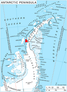
Horseshoe Island is an island 12 km (6.5 nmi) long and 6 km (3 nmi) wide occupying most of the entrance to Square Bay, along the west coast of Graham Land, Antarctica. It was discovered and named by the British Graham Land Expedition under John Rymill who mapped the area by land and from the air in 1936–37. Its name is indicative of the crescentic alignment of the 600 to 900 m peaks which give a comparable shape to the island.
Thomson Head is a steep, rocky headland rising to 915 m at the east side of Bourgeois Fjord, between Perutz and Bader Glaciers, forming the north extremity of German Peninsula on Fallières Coast on the west side of Graham Land, Antarctica. First surveyed in 1936 by the British Graham Land Expedition (BGLE) under Rymill. Resurveyed in 1948-49 by the Falkland Islands Dependencies Survey (FIDS) and named for William H. Thomson, FIDS air pilot at Stonington Island in 1947.

Russet Pikes are Antarctic peaks just east of the mouth of Gaul Cove on Horseshoe Island. Surveyed by Falkland Islands Dependencies Survey (FIDS) in 1955–57. The name is descriptive; reddish-brown colour is visible on the feature most of the year, the slopes being too steep to retain snow cover for any length of time.
Varcoe Headland is a low headland, with an elevation of 34 m, that marks the north entrance point to Horseshoe Bay in west Ross Island. It was named by the New Zealand Geographic Board (NZGB) after Technical Services Officer Garth Edwin Varcoe, who worked in the New Zealand Antarctic Programme over a period of 15 years until his accidental death in a helicopter crash near this headland in October 1992. His expertise was in the mechanical and electrical areas and he played a leading role in the reconstruction of Scott Base.

The Ryder Bay Islands Important Bird Area is a 520 ha designated site on the south-east coast of Adelaide Island, Antarctica. It has been identified as an Important Bird Area (IBA) by BirdLife International because it supports significant numbers of breeding seabirds, notably south polar skuas. The site encompasses the Léonie Islands lying at the mouth of Ryder Bay, as well as Rothera Point, the eastern headland of the bay.