Madagascar is a large island in the Indian Ocean off the eastern coast of southern Africa, east of Mozambique. It has a total area of 587,040 square kilometres (226,660 sq mi) with 581,540 square kilometres (224,530 sq mi) of land and 5,500 square kilometres (2,100 sq mi) of water. Madagascar is the fourth largest island and the 2nd largest island country in the world. The highest point is Maromokotro, in the Tsaratanana Massif region in the north of the island, at 2,876 metres (9,436 ft). The capital Antananarivo is in the Central Highlands near the centre of the island. It has the 25th largest Exclusive Economic Zone of 1,225,259 km2 (473,075 sq mi). Madagascar is 400 kilometres east of mainland Africa.

Mahajanga was a former province of Madagascar that had an area of 150,023 km². It had a population of 1,896,000 (2004). Its capital was Mahajanga, the second largest city in Madagascar.
Antsiafabositra is a town and commune in central Madagascar approximately 170 kilometres north-west of the capital Antananarivo. It belongs to the district of Maevatanana, which is a part of Betsiboka Region. The population of the commune was estimated to be approximately 8,000 in 2001 commune census.
Kandreho is a municipality in western Madagascar in Betsiboka Region approximately 200 kilometres (120 mi) north-west of the capital Antananarivo. It is situated at 144 km from Maevatanana.
Articles related to Madagascar include:

Betsiboka River is a 525-kilometre (326 mi) long river in central-north Madagascar. It flows northwestward and empties to Bombetoka Bay, forming a large delta. It originates to the east of Antananarivo. The river is surrounded in mangroves. The river is distinctive for its red-coloured water, which is caused by river sediments. The river carries an enormous amount of reddish-orange silt to the sea. Much of this silt is deposited at the mouth of the river or in the bay.

Analamanga is a region in central Madagascar, containing the capital Antananarivo and its surrounding metropolitan area. The region has an area of 17,488 square kilometres, and had a population of 3,618,128 in 2018.

Maevatanana is an urban municipality in Madagascar. The city is in the central-north part of the island, at the Ikopa River, and is connected by the national road RN 4 to Antananarivo and Mahajanga. The altitude is low and as it is located far from the coast, temperatures tend to be high. The city belongs to the district of Maevatanana, which is a part of Betsiboka Region. Maevatanana is the capital of the Betsiboka region, and the population of the commune was estimated to be approximately 24,000 in 2001 commune census.
Marovoay is an urban municipality in north-western Madagascar. It belongs to the district of Marovoay, which is a part of Boeny Region. The population of the commune was estimated to be approximately 65,000 in 2001 commune census.
Morafeno is the name of several municipalities in Madagascar:
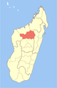
Betsiboka is a region of Madagascar. It borders Boeny Region in north, Sofia in northeast, Alaotra-Mangoro in east, Analamanga and Bongolava in south and Melaky in west. The capital of the region is Maevatanana. Until 2009 Betsiboka belonged to Mahajanga Province. The population was 394,561 in 2018 within the area of 30,025 km2 (11,593 sq mi). Betsiboka is one of the least densely populated regions in Madagascar.
Marovoay Banlieue is a rural municipality in Madagascar. It belongs to the district of Marovoay, which is a part of Boeny Region. The population of the commune was estimated to be approximately 9,000 in 2001 commune census.
Boanamary is a rural municipality in Madagascar. It belongs to the district of Mahajanga II, which is a part of Boeny Region. The population of the commune was estimated to be approximately 10,000 in 2001 commune census.
Antanimbary is a town and commune in Madagascar. It belongs to the district of Maevatanana, which is a part of Betsiboka Region. The population of the commune was estimated to be approximately 3,000 in 2001 commune census.
Mahatsinjo is a rural municipality in Madagascar. It belongs to the district of Maevatanana, which is a part of Betsiboka Region. The population of the municipality was 14675 in 2018.
The Betsiboka Bridge is a truss bridge over the Betsiboka River, in the district of Maevatanana, which is a part of Betsiboka Region, Madagascar. It is one of the longest bridge on the island, appr. 350 meters long.
Maevatanana is a district of Betsiboka in Madagascar.
Route nationale 4 (RN4) is a primary highway in Madagascar. The route runs from the capital city of Antananarivo to Mahajanga, a city on the north-east coast of the Madagascar. It covers a distance of 570 km.
Berivotra is a rural municipality in Madagascar. It belongs to the district of Maevatanana, which is a part of Betsiboka Region. The population of the municipality was 14,675 in 2018.
Maevatanana may refer to municipalities in Madagascar: