The Santa Ana River is the largest river entirely within Southern California in the United States. It rises in the San Bernardino Mountains and flows for most of its length through San Bernardino and Riverside Counties, before cutting through the northern Santa Ana Mountains via Santa Ana Canyon and flowing southwest through urban Orange County to drain into the Pacific Ocean. The Santa Ana River is 96 miles (154 km) long, and its drainage basin is 2,650 square miles (6,900 km2) in size.

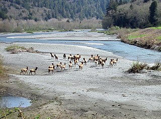
The Eel River is a major river, about 196 miles (315 km) long, of northwestern California. The river and its tributaries form the third largest watershed entirely in California, draining a rugged area of 3,684 square miles (9,540 km2) in five counties. The river flows generally northward through the Coast Ranges west of the Sacramento Valley, emptying into the Pacific Ocean about 10 miles (16 km) downstream from Fortuna and just south of Humboldt Bay. The river provides groundwater recharge, recreation, and industrial, agricultural and municipal water supply.

The Mattole, including the Bear River Indians, are a group of Native Americans in California. Their traditional lands were along the Mattole and Bear Rivers near Cape Mendocino in Humboldt County, California. A notable difference between the Mattole and other indigenous peoples of California is that the men traditionally had facial tattoos, while other local groups traditionally restricted facial tattooing to women.

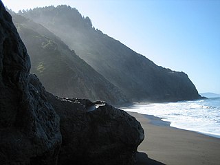
The Lost Coast is a mostly natural and undeveloped area of the California North Coast in Humboldt and Mendocino Counties, which includes the King Range. It was named the "Lost Coast" after the area experienced depopulation in the 1930s. In addition, the steepness and related geotechnical challenges of the coastal mountains made this stretch of coastline too costly for state highway or county road builders to establish routes through the area, leaving it the most undeveloped and remote portion of the California coast. Without any major highways, communities in the Lost Coast region such as Petrolia, Shelter Cove, and Whitethorn are isolated from the rest of California.

The King Range is a mountain range of the Outer Northern California Coast Ranges System, located entirely within Humboldt County on the North Coast of California.

Honeydew is an unincorporated community in Humboldt County, California. It is located 17 miles (27 km) south of Scotia, at an elevation of 322 feet, 15 miles (24 km) from the Pacific Ocean in the Lost Coast, near the King Range. It has a general store, elementary school, post office, and a few houses nearby. Many of the locals live in the hills surrounding the Mattole valley, named after the Mattole River which runs through the valley. The ZIP code is 95545 and the community is inside area code 707.
The Mendocino Range is one of several coastal mountain ranges which compose the Pacific Coast Range. This massive range of coastal mountains was formed during a period of coastal orogeny, millions of years ago. The Mendocino Range is a component of the California Coast Ranges of California. The Klamath Range is north of this region, and the Cascade Range runs to the northeast.

The Mad River is a river in upper Northern California. It flows for 113 miles (182 km) in a roughly northwest direction through Trinity County and then Humboldt County, draining a 497-square-mile (1,290 km2) watershed into the Pacific Ocean north of the town of Arcata near Arcata-Eureka Airport in McKinleyville. The river's headwaters are in the Coast Range near South Kelsey Ridge.

The Mattole River is a river on the north coast of California, that flows northerly, then westerly into the Pacific Ocean. The vast majority of its 62 miles (100 km) course is through southern Humboldt County, though a short section of the river flows through northern Mendocino County. Communities, from north to south, closely associated with the Mattole River include: Petrolia, Honeydew, Ettersburg, Thorn Junction, and Whitethorn. The river enters the ocean at the Mattole Estuary about 4 miles (6.4 km) west-southwest of Petrolia and 10 miles (16 km) south of Cape Mendocino.

Redwood Creek is a 61.8-mile (99.5 km) river in Humboldt County, California. The river's headwaters are in the Coast Range at about 5,000 feet (1,500 m) and it flows roughly northwest until it empties into the Pacific Ocean near the small town of Orick, the only development in the 280-square-mile (730 km2)-watershed.

The Van Duzen River is a river on the north coast of California. It is a major tributary of the Eel River and drains 429 square miles (1,110 km2), mostly in Humboldt County, with a small portion in Trinity County. The river travels 63 miles (101 km) from its headwaters on the west side of the North Coast Range to its confluence with the Eel River, about 14 miles (23 km) upstream from the Pacific Ocean and 17 miles (27 km) south of Eureka, California. The river's elevation is over 5,000 feet (1,500 m) at its source and only 60 feet (18 m) when it merges with the Eel River. The river has two forks in its upper reaches. The North Fork travels northwest until it reaches the small town of Dinsmore, where it starts flowing west. The Little Van Duzen, which also flows northwest, joins the North Fork a few miles later. The river flows roughly west from then on. It meets its largest tributary, Yaeger Creek, about 5 miles (8.0 km) before it reaches the Eel River.

Petrolia is an unincorporated community in Humboldt County, California, 10 miles (16 km) southeast of Cape Mendocino, at an elevation of 121 feet (37 m) above sea level, within ZIP Code 95558, and area code 707. Petrolia was the site of the first oil well drilled in California.

The King Range Wilderness is a 42,585-acre (172 km2) federally designated wilderness area within the King Range National Conservation Area in northern California, United States. The area was set aside with the passage of the Northern California Coastal Wild Heritage Wilderness Act of 2006. The Bureau of Land Management is the responsible agency and is currently working on a Management Plan for the King Range Wilderness. This section of California's coastline is known as the "Lost Coast", a landscape too rugged for highway building, which forced the construction of State Highway 1 and U.S. 101 inland. The King Range Wilderness is the longest undeveloped coast, outside of Alaska, in the United States.

The South Fork Eel River is the largest tributary of the Eel River in north-central California in the United States. The river flows 105 miles (169 km) north from Laytonville to Dyerville/Founders' Grove where it joins the Eel River. The South Fork drains a long and narrow portion of the Coast Range of California in parts of Mendocino and Humboldt counties. U.S. Route 101 follows the river for much of its length.

The Middle Fork Eel River is a major tributary of the Eel River of northwestern California in the United States. It drains a rugged and sparsely populated region of the Yolla Bolly Mountains, part of the California Coast Range, in Trinity and Mendocino Counties. Its watershed comprises roughly 745 square miles (1,930 km2) of land, or 20% of the entire Eel River basin. The river provides groundwater recharge and is used for recreation and for industrial, agricultural and municipal water supply by residents.

Outlet Creek is an Eel River tributary draining the Little Lake Valley northerly through a canyon of the California Coast Ranges. The Northwestern Pacific Railroad bridges the creek twelve times, following it through the canyon. California State Route 162 bridges the creek once, following the canyon closely downstream of Longvale, California, and U.S. Route 101 bridges the creek twice, paralleling it less closely upstream of Longvale. After leaving Quaternary alluvium of the Little Lake Valley, the canyon exposes undivided Cretaceous marine sedimentary and metasedimentary rocks upstream of Longvale and Franciscan Assemblage downstream of Longvale. Outlet Creek provides groundwater recharge, recreation, and agricultural and industrial water supply plus wildlife habitat including cold freshwater habitat for fish migration and spawning.

The Salt River is a formerly navigable hanging channel of the Eel River which flowed about 9 miles (14 km) from near Fortuna and Waddington, California, to the estuary at the Pacific Ocean, until siltation from logging and agricultural practices essentially closed the channel. It was historically an important navigation route until the early 20th century. It presently intercepts and drains tributaries from the Wildcat Hills along the south side of the Eel River floodplain. Efforts to restore the river began in 1987, permits and construction began in 2012, and water first flowed in the restored channel in October 2013.

Bull Creek is the largest Eel River tributary drainage basin preserved within Humboldt Redwoods State Park. The basin contains the world's largest remaining contiguous old-growth forest of coast redwoods. Bull Creek flows in a clockwise semi-circle around 3373-foot (1028-meter) Grasshopper Mountain to enter the South Fork Eel River approximately 1.5 miles (2.5 km) upstream of the South Fork confluence with the Eel River.

Little River is the largest Pacific coastal drainage basin between the Mad River and Big Lagoon. Its 19.6 miles (31.5 km) of river drains forested Franciscan assemblage of the California Coast Ranges. The lowermost mile of channel is through Quaternary alluvium and dune sand of an estuarine floodplain typical of coastal inlets along the Cascadia subduction zone. Land seaward of U.S. Route 101 forms Little River State Beach and Clam Beach County Park. Little River State Park was established in 1931. The floodplain upstream of the highway 101 bridge is cleared as grazing pasture; and the upland portion of the drainage basin, including the former company town of Crannell, is in private ownership growing forest products. In 2014 the North Coast regional water board recommended that Little River be listed and an impaired waterway due to E. coli contamination 600 times greater than normal.
Blue goo is a sticky, plasticky, blueish-grey, clay-textured soil derived from a highly weathered serpentinite mélange. The name derives from the soil's color; a result of undergoing anaerobic conditions and becoming gleyed. A greyer variation is called "grey goo". Blue goo is primarily found along the Northern California coast.


