Beaver River (Grey County)

Last updated
Beaver River
Eugenia Falls.JPG
The Beaver River passing over the Eugenia Falls
Canada Southern Ontario relief location map.jpg
Red pog.svg
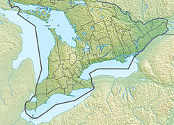
Location of the mouth of the Beaver River in southern Ontario
Location
CountryCanada
Province Ontario
RegionSouthern Ontario
Counties
Physical characteristics
Source field
  location Clearview, Simcoe County
  coordinates 44°23′29″N80°15′27″W / 44.39139°N 80.25750°W / 44.39139; -80.25750
  elevation513 m (1,683 ft)
Mouth Georgian Bay on Lake Huron
  location
The Blue Mountains, Grey County
  coordinates
44°33′54″N80°26′52″W / 44.56500°N 80.44778°W / 44.56500; -80.44778
  elevation
176 m (577 ft)
Basin features
River system Great Lakes Basin
Tributaries 
  left Boyne River, Little Beaver River

The Beaver River is a river in Grey County and Simcoe County in Southern Ontario, Canada. [1] It is part of the Great Lakes Basin, and is a tributary of Lake Huron. The river's drainage basin is under the auspices of Grey Sauble Conservation. [2]
Contents

Course

The river begins in a field in Clearview, Simcoe County, and flows west immediately into Grey Highlands, Grey County. The river continues southwest, takes in the left tributary Little Beaver River, and heads into Eugenia Lake at the edge of the Niagara Escarpment at the community of Eugenia; the lake was formed when the river was regulated for flow control and a hydroelectric plant was built. It continues over the Eugenia Falls and takes in the left tributary Boyne River, and turns north, flowing through Beaver Valley into the municipality of The Blue Mountains. The river then heads north, passes over two dams and reaches its mouth at Nottawasaga Bay on Georgian Bay, Lake Huron, at the community of Thornbury.

Natural history

A fish ladder near Thornbury allows fish to reach spawning areas up river.

Recreation

The river is also a popular recreational canoe route. The Beaver River valley is home to the Beaver Valley Ski Club.

Tributaries

Related Research Articles

<span class="mw-page-title-main">Lake Simcoe</span> Lake in Ontario, Canada

Lake Simcoe is a lake in southern Ontario, Canada, the fourth-largest lake wholly in the province, after Lake Nipigon, Lac Seul, and Lake Nipissing. At the time of the first European contact in the 17th century the lake was called Ouentironk by the native Wendat/Ouendat (Huron) people. It was also known as Lake Taronto until it was renamed by John Graves Simcoe, the first Lieutenant-Governor of Upper Canada, in memory of his father, Captain John Simcoe of the Royal Navy. In Anishinaabemowin, the ancestral language of the First Nations living around this lake, namely Anishinaabek of Rama and Georgina Island First Nations, Lake Simcoe is called Zhooniyaang-zaaga'igan, meaning "Silver Lake".

<span class="mw-page-title-main">Humber River (Ontario)</span> River in Canada

The Humber River is a river in Southern Ontario, Canada. It is in the Great Lakes Basin, is a tributary of Lake Ontario and is one of two major rivers on either side of the city of Toronto, the other being the Don River to the east. It was designated a Canadian Heritage River on September 24, 1999.

<span class="mw-page-title-main">Nottawasaga River</span> River in Ontario, Canada

The Nottawasaga River is a river in Simcoe County and Dufferin County in Central Ontario, Canada. It is part of the Great Lakes Basin, and is a tributary of Lake Huron. The river flows from the Orangeville Reservoir in the town of Orangeville, Dufferin County, through the Niagara Escarpment and the Minesing Wetlands, the latter a wetland of international significance, and empties into Nottawasaga Bay, an inlet of Georgian Bay on Lake Huron, at the town of Wasaga Beach, Simcoe County.

<span class="mw-page-title-main">Sauble River (Ontario)</span> River in Ontario, Canada

The Sauble River is a river in Bruce County and Grey County in southwestern Ontario, Canada that flows from its headwaters in the township of Chatsworth to Lake Huron north of the community of Sauble Beach.

<span class="mw-page-title-main">Rankin River</span> River in Ontario, Canada

The Rankin River is a river in the town of South Bruce Peninsula, Bruce County in southwestern Ontario, Canada which flows from the east side of the Bruce Peninsula to join the Sauble River near Sauble Falls Provincial Park on the west side. The river is in the Lake Huron drainage basin and was named after Charles Rankin, who first surveyed the Bruce Peninsula.

<span class="mw-page-title-main">Maitland River</span> River in Ontario, Canada

The Maitland River is a river in Huron County, Perth County and Wellington County in Southwestern Ontario, Canada. The river is in the Great Lakes Basin and empties into Lake Huron at the town of Goderich. It is 150 kilometres (93 mi) long, and is named after Sir Peregrine Maitland, Lieutenant-Governor of Upper Canada from 1818 to 1828. It was formerly known as the Menesetung River.

The Pottawatomi River is a river in the municipalities of Owen Sound and Georgian Bluffs, Grey County in Southwestern Ontario, Canada. It is in the Great Lakes Basin and empties into Owen Sound, an inlet of Georgian Bay on Lake Huron, at Owen Sound Harbour.

<span class="mw-page-title-main">Crowe River</span> River in Ontario, Canada

The Crowe River is a river in the counties of Haliburton, Hastings, Northumberland and Peterborough in southern Ontario, Canada. It is in the Lake Ontario drainage basin and is a tributary of the Trent River.

<span class="mw-page-title-main">Eugenia, Ontario</span> Place in Ontario, Canada

Eugenia is a small community in the municipality of Grey Highlands, Grey County, in Southwestern Ontario, Canada, located just north of the community of Flesherton. An unincorporated hamlet of Artemesia Township for most of its history, Eugenia was amalgamated into the Grey Highlands in 2001. Due to nearby Lake Eugenia, Eugenia Falls, the Bruce Trail and the ski resorts of the Beaver Valley, it has become a popular tourist and cottage destination. The nearby Eugenia Power Station has the highest head of water of any hydroelectric generator in Ontario, and has provided a significant amount of electricity to the provincial grid for a century.

Sixteen Mile Creek is a stream in the municipality of Lake of Bays, District Municipality of Muskoka in Central Ontario, Canada. It is part of the Great Lakes Basin and flows from Hickory Lake to its mouth at the Boyne River. The Boyne River flows to the Lake of Bays, then via the Muskoka River, and the Moon River and Musquash River to Georgian Bay on Lake Huron.

The Boyne River is a river in the municipality of Lake of Bays, District Municipality of Muskoka in Central Ontario, Canada. It is part of the Great Lakes Basin, and flows from Fowler Lake to its mouth at Dwight Bay on the Lake of Bays near the community of Dwight on Ontario Highway 60. The Lake of Bays flows via the Muskoka River, then the Moon River and Musquash River to Georgian Bay on Lake Huron.

<span class="mw-page-title-main">Boyne River (Grey County)</span> River in Ontario, Canada

The Boyne River is a river in the municipality of Grey Highlands, Grey County in Southwestern Ontario, Canada. It is part of the Great Lakes Basin, and lies entirely within geographic Artemesia Township.

<span class="mw-page-title-main">Boyne River (Nottawasaga River tributary)</span> River in Ontario, Canada

The Boyne River is a river in Simcoe County and Dufferin County in Central Ontario, Canada. It is part of the Great Lakes Basin, and is a left tributary of the Nottawasaga River. The rivers falls within the jurisdiction of the Nottawasaga Valley Conservation Authority.

<span class="mw-page-title-main">Beaver River (Lake Simcoe)</span> River in Ontario, Canada

The Beaver River is a river in Durham Region in Central Ontario, Canada. It is part of the Great Lakes Basin, and is a tributary of Lake Simcoe. The river's drainage basin is mostly in Durham Region with the remaining portion in the city of Kawartha Lakes; the entire watershed is under the auspices of the Lake Simcoe Region Conservation Authority.

<span class="mw-page-title-main">Black River (York Region)</span> River in Ontario, Canada

The Black River is a river in the Regional Municipality of York and the Regional Municipality of Durham in Central Ontario, Canada. It is part of the Great Lakes Basin, and is a tributary of Lake Simcoe; the entire watershed is under the auspices of the Lake Simcoe Region Conservation Authority.

The Black River is a river in Simcoe County in Central Ontario, Canada. It is part of the Great Lakes Basin, and is a left tributary of the Severn River.

The Little White River is a river in the Unorganized North Part of Algoma District in Northeastern Ontario, Canada. It is in the Great Lakes Basin and is a left tributary of the Mississagi River.

The Black River is a river in Simcoe County, the District Municipality of Muskoka, the City of Kawartha Lakes, and Haliburton County in Central Ontario, Canada. It is part of the Great Lakes Basin, and is a right tributary of the Severn River.

Little Mud Lake is a lake in South Bruce Peninsula, Bruce County in southwestern Ontario, Canada. It is part of the Great Lakes Basin, and is about 5.5 kilometres (3.4 mi) northwest of the community of Wiarton.

Bid Mud Lake is a lake in South Bruce Peninsula, Bruce County in southwestern Ontario, Canada. It is part of the Great Lakes Basin, and is about 6 kilometres (3.7 mi) northwest of the community of Wiarton.

References

  1. "Beaver River". Geographical Names Data Base . Natural Resources Canada . Retrieved 2014-04-19.
  2. "Watershed Report Card 2013" (PDF). Grey Sauble Conservation. 2013. Archived from the original (PDF) on 2014-04-17. Retrieved 2014-04-19.

Sources

See also