The Blue Mountains, Ontario

Last updated

The Blue Mountains
Town of The Blue Mountains
Blue Mountains ON gondola.jpg
Town of The Blue Mountains viewed from the top of Blue Mountain
Grey locator map 2021.svg
Red pog.svg
The Blue Mountains
Canada Southern Ontario location map 2.png
Red pog.svg
The Blue Mountains
Coordinates: 44°29′N80°23′W / 44.483°N 80.383°W / 44.483; -80.383
Country Canada
Province Ontario
County Grey
FormedJanuary 1, 1998
Government
  MayorAndrea Matrosovs
  Federal riding Simcoe—Grey
  Prov. riding Simcoe—Grey
Area
[1]
  Land287.24 km2 (110.90 sq mi)
Population
 (2016) [1]
  Total
7,025
  Density24.5/km2 (63/sq mi)
Time zone UTC-5 (EST)
  Summer (DST) UTC-4 (EDT)
Postal Code
N0H 2P0
Area code(s) 519 & 226
Highways Ontario 26 crown.svg  Highway 26
Website www.thebluemountains.ca

The Blue Mountains is a town in Grey County, southwestern Ontario, Canada, located where the Beaver River flows into Nottawasaga Bay. It is named for the Blue Mountain, and hence the economy of the town is centred on tourism, particularly on the Blue Mountain ski resort and the private Georgian Peaks, Osler, Craigleith and Alpine Ski Clubs.

Contents

The town was formed on January 1, 1998, when the Town of Thornbury was amalgamated with the Township of Collingwood. Thornbury is home to the architecturally unique L.E. Shore Memorial Library, named after the founding partner of the architectural practice of Shore Tilbe Irwin + Partners, and designed by the firm.

During the Southern Ontario Tornado Outbreak of 2009, a tornado passed through the Blue Mountains area on August 20. The tornado passed by Thornbury and hit Craigleith before moving out onto Georgian Bay.

Recreation

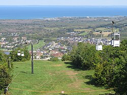
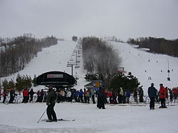
The Blue Mountains has a host of recreational activities for all seasons. Most notably is the winter skiing, snowboarding, snowshoeing and cross-country skiing. In the summer there is hiking, downhill/cross-country biking, a scenic putting course, [2] the Ridge Runner coaster [3] and events such as Met Con Blue. [4] The Village at Blue Mountain [5] has boutiques, coffee shops, restaurants, hotels and chalets, as well as golf courses within walking distance. Less than a 5-minute drive away there is the Scandinave Spa [6] , situated on 25 acres of natural Ontario birch, as well as the Scenic Caves. [7]

Craigleith Provincial Park is located along Highway 26 near Blue Mountain resort.

The Bruce Trail passes through sections of the town. Nearby are the Kolapore area for mountain biking and cross-country skiing, Metcalfe Rock which is popular with rock climbers, and the Duncan Crevice Caves Nature Reserve.

Communities

Residential area across from the ski hills Blue Mountains Ontario residential.jpg
Residential area across from the ski hills
Thornbury harbour from the Royal Harbour Resort Thornbury Harbour Entrance.JPG
Thornbury harbour from the Royal Harbour Resort

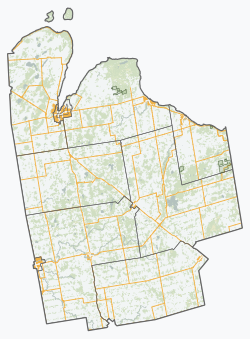
The primary population centres are Thornbury and the modern resort-style communities clustered around the foot of the escarpment near the ski resorts, commonly referred to as Blue Mountain Village. Additionally the town's territory also includes the rural communities of Banks, Camperdown, Castle Glen Estates, Christie Beach, Clarksburg, Craigleith, Duncan, Gibraltar, Swiss Meadows, Heathcote, Kolapore, Little Germany, Lora Bay, Loree, Ravenna, Red Wing, Slabtown, and Victoria Corners.

Thornbury

Thornbury was first incorporated in 1831 and divided from Collingwood Township in 1887 as a separate administration. [8] It existed as a separate municipality until 1998 when it remerged with Collingwood Township to form Town of The Blue Mountains municipality. The town was a shipping and processing centre for local agricultural produce especially apples through its harbour on Georgian Bay, Lake Huron. There was also a small fishing fleet that operated from the harbour and the post office dates from 1854. [9]

Thornbury's Grand Trunk Railway station c. 1910. Thornbury, ON GTR station c1910.jpg
Thornbury's Grand Trunk Railway station c.1910.

Rail service reached Thornbury on September 2, 1872, when the Northern Railway of Canada's North Grey Railway was built westward through Grey County from Collingwood to Meaford; the line reached Meaford later that year, in December. [10] The line was originally planned to extend all the way to Owen Sound, but this vision went unrealized due to factors such as terrain, financial limitations, and competition from the Toronto, Grey and Bruce Railway, which reached Owen Sound in 1873. [11] The railway was later part of the Grand Trunk Railway and Canadian National Railways (CNR) systems. Thereafter, it became known as the CN Meaford Subdivision. Regular passenger service ceased in 1960; the line itself was abandoned in 1985. [11]

Many large late nineteenth century houses on tree lined streets characterize the town suburbs. [12] Thornbury is home to the architecturally unique L.E. Shore Memorial Library, built in 1995 and named after the founding partner of the architectural practice of Shore Tilbe Irwin + Partners who designed it. [13] In more recent years, Thornbury has become a winter and summer destination for individuals from across Ontario to vacation. The town also holds an annual Canada Day celebration that takes place on the main street. [14]

Climate

Climate data for Thornbury, Ontario (1981−2010)
MonthJanFebMarAprMayJunJulAugSepOctNovDecYear
Record high °C (°F)15.0
(59.0)
18.0
(64.4)
24.0
(75.2)
30.5
(86.9)
32.8
(91.0)
34.0
(93.2)
35.5
(95.9)
36.0
(96.8)
33.5
(92.3)
28.9
(84.0)
22.5
(72.5)
20.0
(68.0)
36.0
(96.8)
Mean daily maximum °C (°F)−2.6
(27.3)
−1.5
(29.3)
2.9
(37.2)
10.2
(50.4)
16.6
(61.9)
22.0
(71.6)
24.8
(76.6)
24.0
(75.2)
20.1
(68.2)
13.2
(55.8)
6.5
(43.7)
0.6
(33.1)
11.4
(52.5)
Daily mean °C (°F)−6.3
(20.7)
−5.4
(22.3)
−1.5
(29.3)
5.5
(41.9)
11.5
(52.7)
16.7
(62.1)
19.8
(67.6)
19.2
(66.6)
15.5
(59.9)
9.1
(48.4)
3.1
(37.6)
−2.7
(27.1)
7.0
(44.6)
Mean daily minimum °C (°F)−9.9
(14.2)
−9.3
(15.3)
−5.8
(21.6)
0.9
(33.6)
6.2
(43.2)
11.4
(52.5)
14.8
(58.6)
14.3
(57.7)
10.8
(51.4)
4.9
(40.8)
−0.3
(31.5)
−5.9
(21.4)
2.7
(36.9)
Record low °C (°F)−30.6
(−23.1)
−31.5
(−24.7)
−28.0
(−18.4)
−13.3
(8.1)
−3.3
(26.1)
0.6
(33.1)
5.0
(41.0)
3.9
(39.0)
−2.0
(28.4)
−5.0
(23.0)
−16.5
(2.3)
−26.0
(−14.8)
−31.5
(−24.7)
Average precipitation mm (inches)100.0
(3.94)
68.4
(2.69)
64.0
(2.52)
65.3
(2.57)
82.7
(3.26)
79.1
(3.11)
72.1
(2.84)
78.2
(3.08)
95.9
(3.78)
87.3
(3.44)
99.6
(3.92)
99.4
(3.91)
991.9
(39.05)
Average rainfall mm (inches)20.9
(0.82)
19.4
(0.76)
36.7
(1.44)
57.4
(2.26)
82.7
(3.26)
79.1
(3.11)
72.1
(2.84)
78.2
(3.08)
95.9
(3.78)
84.0
(3.31)
70.4
(2.77)
28.5
(1.12)
725.3
(28.56)
Average snowfall cm (inches)79.1
(31.1)
49.0
(19.3)
27.4
(10.8)
7.9
(3.1)
0.0
(0.0)
0.0
(0.0)
0.0
(0.0)
0.0
(0.0)
0.0
(0.0)
3.3
(1.3)
29.2
(11.5)
70.8
(27.9)
266.6
(105.0)
Average precipitation days (≥ 0.2 mm)18.913.312.512.612.010.69.510.813.215.816.317.6163.0
Average rainy days (≥ 0.2 mm)4.23.86.911.512.010.69.510.813.215.512.56.4116.9
Average snowy days (≥ 0.2 cm)15.910.67.02.20.00.00.00.00.00.675.012.353.6
Source: Environment Canada [15]

Demographics

Historical populations
YearPop.±%
19915,036    
1996 5,667+12.5%
2001 6,116+7.9%
2006 6,825+11.6%
2011 6,453−5.5%
2016 7,025+8.9%

In the 2021 Census of Population conducted by Statistics Canada, The Blue Mountains had a population of 9,390 living in 4,348 of its 7,396 total private dwellings, a change of 33.7% from its 2016 population of 7,025. With a land area of 284.65 km2 (109.90 sq mi), it had a population density of 33.0/km2 (85.4/sq mi) in 2021. [16]

Canada census – The Blue Mountains, Ontario community profile
2016 2011
Population7,025 (+8.9% from 2011)6,453 (-5.5% from 2006)
Land area287.24 km2 (110.90 sq mi)287.23 km2 (110.90 sq mi)
Population density24.5/km2 (63/sq mi)22.5/km2 (58/sq mi)
Median age57.6 (M: 57.7, F: 57.6)
Private dwellings6,477 (total) 6,200 (total) 
Median household income$78,490
References: 2016 [17] 2011 [18]

Population trend: [19]

Canada 2016 CensusPopulation% of Total population
Visible minority group
Source: [20]
South Asian 00
Chinese 200.2
Black 00
Filipino 200.2
Latin American 00
Southeast Asian 00
Other visible minority600.8
Total visible minority population1001.4
Aboriginal group
Source: [20]
First Nations 801.1
Métis 300.4
Inuit 00
Total Aboriginal population1051.4
White 6,82097.1
Total population7,025100

Notable residents

Images

See also

References

  1. 1 2 "Census Profile, 2016 Census: The Blue Mountains, Town". Statistics Canada . Retrieved June 13, 2019.
  2. https://www.bluemountain.ca/things-to-do/activities/cascade-putting-course
  3. https://www.bluemountain.ca/things-to-do/activities/ridge-runner-coaster
  4. Met Con Blue Mountain Adventure Race
  5. Blue Mountain Village
  6. Scandinave Spa Blue Mountain
  7. Scenic Caves Nature Adventures
  8. "Thornbury BIA - 3". www.thornbury.ca. Retrieved 2016-07-11.[ dead link ]
  9. Hamilton, William (1978). The Macmillan Book of Canadian Place Names. Toronto: Macmillan. p. 174. ISBN   0-7715-9754-1.
  10. Smith, Jeffrey P. (20 June 2016). "C.N.Rys. Meaford Subdivision". CNR-in-Ontario.com. Retrieved 19 December 2021.
  11. 1 2 Cooper, Charles. "The North Grey Railway" (PDF).
  12. "We Used to have a Railway Running through Thornbury" (PDF). beavervalleyprobus.com/. Archived from the original (PDF) on September 18, 2016. Retrieved July 11, 2016.
  13. "The Leonard E. Shore Memorial Library: A Living Legacy" (PDF). The Blue Mountains Public Library. 30 Nov 2012.[ dead link ]
  14. "Canada Day - Town of the Blue Mountains, ON".
  15. "Thornbury Slama". Canadian Climate Normals 1981–2010. Environment Canada. 25 September 2013. Archived from the original on July 24, 2019. Retrieved July 24, 2019.
  16. "Population and dwelling counts: Canada, provinces and territories, census divisions and census subdivisions (municipalities), Ontario". Statistics Canada. February 9, 2022. Retrieved March 30, 2022.
  17. "2016 Community Profiles". 2016 Canadian census . Statistics Canada. August 12, 2021. Retrieved 2019-06-13.
  18. "2011 Community Profiles". 2011 Canadian census . Statistics Canada. March 21, 2019. Retrieved 2012-03-15.
  19. Statistics Canada: 1996, 2001, 2006 census
  20. 1 2 "Blue Mountains, Ontario (Town) Census Subdivision". Community Profiles, Canada 2006 Census . Statistics Canada.