Boyne River (Grey County)

Last updated
Boyne River
River
Hoggs Falls.jpg
The river passing over Hoggs Falls
Country Canada
Province Ontario
Region Southwestern Ontario
County Grey
Municipality Grey Highlands
Part of Great Lakes Basin
Tributaries
 - rightFlesherton Creek
Source Wilcox Lake
 - elevation469 m (1,539 ft)
 - coordinates 44°13′52″N80°33′30″W / 44.23111°N 80.55833°W / 44.23111; -80.55833
Mouth Beaver River
 - elevation295 m (968 ft)
 - coordinates 44°18′53″N80°32′22″W / 44.31472°N 80.53944°W / 44.31472; -80.53944 Coordinates: 44°18′53″N80°32′22″W / 44.31472°N 80.53944°W / 44.31472; -80.53944
Canada Southern Ontario location map 2.png
Red pog.svg
Location of the mouth of the Boyne River in southern Ontario

The Boyne River is a river in the municipality of Grey Highlands, Grey County in Southwestern Ontario, Canada. [1] It is part of the Great Lakes Basin, and lies entirely within geographic Artemesia Township. [2]

River Natural flowing watercourse

A river is a natural flowing watercourse, usually freshwater, flowing towards an ocean, sea, lake or another river. In some cases a river flows into the ground and becomes dry at the end of its course without reaching another body of water. Small rivers can be referred to using names such as stream, creek, brook, rivulet, and rill. There are no official definitions for the generic term river as applied to geographic features, although in some countries or communities a stream is defined by its size. Many names for small rivers are specific to geographic location; examples are "run" in some parts of the United States, "burn" in Scotland and northeast England, and "beck" in northern England. Sometimes a river is defined as being larger than a creek, but not always: the language is vague.

Grey County County in Ontario, Canada

Grey County is a county of the Canadian province of Ontario. The county seat is in Owen Sound. It is located in the subregion of Southern Ontario named Southwestern Ontario. Grey County is also a part of the Georgian Triangle. At the time of the Canada 2016 Census the population of the County was 93,830.

Southwestern Ontario Secondary region in Ontario, Canada

Southwestern Ontario is a secondary region of Southern Ontario in the Canadian province of Ontario. It occupies most of the Ontario Peninsula bounded by Lake Huron, including Georgian Bay, to the north and northwest; the St. Clair River, Lake St. Clair, and Detroit River, to the west; and Lake Erie to the south. To the east, on land, Southwestern Ontario is bounded by Central Ontario and the Golden Horseshoe. The region had a population of 2,583,544 in 2016.

Contents

Course

The river begins at Wilcox Lake and flows north under the Toronto, Grey and Bruce Railway line. It passes through Flesherton Community Pond at the community of Flesherton, then exits the pond over a weir and passes under Ontario Highway 10. It continues north and starts to descend the Niagara Escarpment by passing over the Hoggs Falls, [3] named after William Hogg,[ citation needed ] takes in the right tributary Flesherton Creek, and continues downhill to its mouth at the Beaver River west of the community of Eugenia. The Beaver River flows to Georgian Bay on Lake Huron.

The Toronto, Grey and Bruce Railway was chartered in 1868 to build a narrow-gauge railway from Toronto to Grey and Bruce Counties in Ontario, Canada.

Flesherton Former Village in Ontario, Canada

Flesherton is a community in the Municipality of Grey Highlands, in Grey County, Ontario, Canada, located at the junction of Highway 10 and Grey County Road 4. Although the area initially showed a high rate of growth in the 1850s and its founder believed that it would become an important centre of economic activity, growth stagnated when an all-important rail link bypassed it, and the community never grew larger than a small village. The self-proclaimed "Gateway to the Beaver Valley" recently lost its autonomy as a village when it was amalgamated with the surrounding Artemesia Township.

Weir barrier across a river designed to alter its flow characteristics

A weir or low head dam is a barrier across the horizontal width of a river that alters the flow characteristics of water and usually results in a change in the height of the river level. There are many designs of weir, but commonly water flows freely over the top of the weir crest before cascading down to a lower level.

Tributaries

Related Research Articles

York River (Ontario) river in Canada

The York River is a river in Renfrew County, Hastings County and Haliburton County in Ontario, Canada. The river is in the Saint Lawrence River drainage basin, and flows from the southern extension of Algonquin Provincial Park to the Madawaska River.

Pottawatomi River river in Canada

The Pottawatomi River is a river in the municipalities of Owen Sound and Georgian Bluffs, Grey County in Southwestern Ontario, Canada. It is in the Great Lakes Basin and empties into Georgian Bay on Lake Huron at Owen Sound Harbour.

Crowe River river in Ontario, Canada

The Crowe River is a river in the counties of Haliburton, Hastings, Northumberland and Peterborough in southern Ontario, Canada. It is in the Lake Ontario drainage basin and is a tributary of the Trent River.

Black Lake (Gull River) lake in Minden Hills, Haliburton County in Central Ontario, Canada

Black Lake is a lake in the municipality of Minden Hills, Haliburton County in Central Ontario, Canada. It is part of the Great Lakes Basin and lies within geographic Lutterworth Township.

Clyde River (Ontario)

The Clyde River is a river in Lanark County in Eastern Ontario, Canada. It is in the Saint Lawrence River drainage basin, is a left tributary of the Mississippi River, and was named after the River Clyde in Scotland.

Grey Highlands Municipality in Ontario, Canada

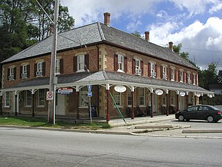
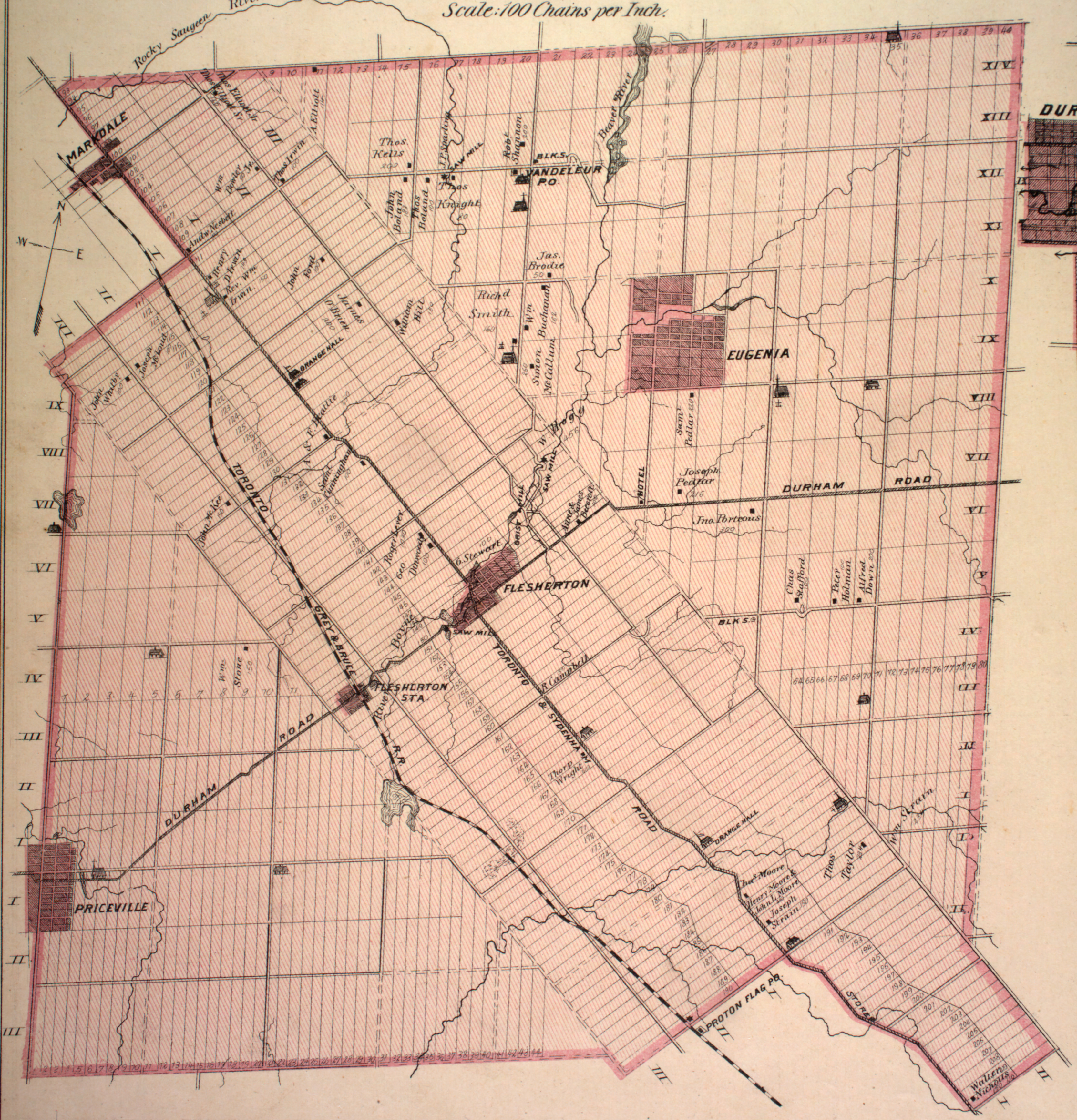
Grey Highlands is a municipality in the southeast corner of Grey County, Ontario, Canada that was formed on January 1, 2001, by the amalgamation of the village of Markdale and the townships of Artemesia, Euphrasia and Osprey, which included the unincorporated hamlets of Eugenia Ceylon, Maxwell, Singhampton, Priceville, Kimberley, and Feversham. The former village of Flesherton is also located within the municipality; it was amalgamated with Artemesia Township in 1998.

Eugenia, Ontario Place in Ontario, Canada

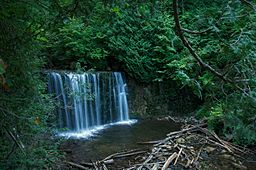
Eugenia is a small community in the municipality of Grey Highlands, Grey County, in Southwestern Ontario, Canada, located just north of the community of Flesherton. An unincorporated hamlet of Artemesia Township for most of its history, Eugenia was amalgamated into the Grey Highlands in 2001. Due to nearby Lake Eugenia, Eugenia Falls, the Bruce Trail and the ski resorts of the Beaver Valley, it has become a popular tourist and cottage destination. The nearby Eugenia Power Station has the highest head of water of any hydroelectric generator in Ontario, and has provided a significant amount of electricity to the provincial grid for a century.

Englehart River river in Canada

The Englehart River is a river in Timiskaming District in northeastern Ontario, Canada. It is in the Saint Lawrence River drainage basin and is a right tributary of the Blanche River.

Nipissing River river in Canada

The Nipissing River is a river in the Saint Lawrence River drainage basin in the Unorganized South Part of Nipissing District in northeastern Ontario, Canada. The river is entirely within Algonquin Provincial Park, and is a left tributary of the Petawawa River.

Blanche River (Lake Timiskaming) river in Canada

The Blanche River is a river in the Saint Lawrence River drainage basin in Timiskaming District in northeastern Ontario, Canada. The river is a tributary of Lake Timiskaming and its name is from the French for the colour "white".

Kapuskasing River river in Northeastern Ontario, Canada

The Kapuskasing River is a river in the James Bay drainage basin in Cochrane District and Algoma District in northeastern Ontario, Canada. The river is a left tributary of the Mattagami River.

Sixteen Mile Creek (Muskoka District)

Sixteen Mile Creek is a stream in the municipality of Lake of Bays, District Municipality of Muskoka in Central Ontario, Canada. It is part of the Great Lakes Basin and flows from Hickory Lake to its mouth at the Boyne River. The Boyne River flows to the Lake of Bays, then via the Muskoka River, and the Moon River and Musquash River to Georgian Bay on Lake Huron.

Boyne River (Muskoka District) River in Muskoka, Ontario, Canada

The Boyne River is a river in the municipality of Lake of Bays, District Municipality of Muskoka in Central Ontario, Canada. It is part of the Great Lakes Basin, and flows from Fowler Lake to its mouth at Dwight Bay on the Lake of Bays near the community of Dwight on Ontario Highway 60. The Lake of Bays flows via the Muskoka River, then the Moon River and Musquash River to Georgian Bay on Lake Huron.

Boyne River (Nottawasaga River tributary) River in the counties of Simcoe and Dufferin in Central Ontario, Canada

The Boyne River is a river in Simcoe County and Dufferin County in Central Ontario, Canada. It is part of the Great Lakes Basin, and is a left tributary of the Nottawasaga River. The rivers falls within the jurisdiction of the Nottawasaga Valley Conservation Authority.

Beaver River (Grey County)

The Beaver River is a river in Grey County and Simcoe County in Southern Ontario, Canada. It is part of the Great Lakes Basin, and is a tributary of Lake Huron. The river's drainage basin is under the auspices of Grey Sauble Conservation.

Black River (Abitibi River tributary) river in Canada

The Black River is a river in Cochrane District and Timiskaming District in Northeastern Ontario, Canada. It is part of the James Bay drainage basin, and is a right tributary of the Abitibi River. The municipality of Black River-Matheson is named after the river.

Black River (Severn River tributary)

The Black River is a river in Simcoe County, the District Municipality of Muskoka, the City of Kawartha Lakes, and Haliburton County in Central Ontario, Canada. It is part of the Great Lakes Basin, and is a right tributary of the Severn River.

Matawin River (Ontario)

The Matawin River is a river in Thunder Bay District in Northwestern Ontario, Canada. It is in the Great Lakes Basin and is a right tributary of the Kaministiquia River.

Irondale River river in Canada

The Irondale River is a river in Haliburton County in Central Ontario, Canada. It is part of the Great Lakes Basin, and is a left tributary of the Burnt River.

Percy Creek (Northumberland County) stream in Northumberland County, Ontario, Canada

Percy Creek is a stream in the municipalities of Trent Hills and Alnwick/Haldimand, Northumberland County, in Central Ontario, Canada. It is in the Great Lakes Basin and is a right tributary of the Trent River. Percy Creek is named after Elizabeth Percy, Duchess of Northumberland.

References

  1. "Boyne River". Geographical Names Data Base. Natural Resources Canada . Retrieved 2014-04-19.
  2. "Township of Artemesia" (JPG). Canadian County Atlas Project. McGill University. 2001. Retrieved 2014-04-19.
  3. "Hoggs Falls". County of Grey. Retrieved 2014-04-19.

Sources

Ministry of Transportation of Ontario government ministry in Ontario

The Ministry of Transportation of Ontario (MTO) is the provincial ministry of the Government of Ontario that is responsible for transport infrastructure and related law in Ontario. The ministry traces its roots back over a century to the 1890s, when the province began training Provincial Road Building Instructors. In 1916, the Department of Public Highways of Ontario (DPHO) was formed and tasked with establishing a network of provincial highways. The first was designated in 1918, and by the summer of 1925, sixteen highways were numbered. In the mid-1920s, a new Department of Northern Development (DND) was created to manage infrastructure improvements in northern Ontario; it merged with the Department of Highways of Ontario (DHO) on April 1, 1937. In 1971, the Department of Highways took on responsibility for Communications and in 1972 was reorganized as the Ministry of Transportation and Communications (MTC), which then became the Ministry of Transportation in 1987.

The Ministry of Municipal Affairs and Housing is the department of the Government of Ontario that is responsible for municipal affairs and housing in the Canadian province of Ontario.