
Trout Lake is an unincorporated community and census-designated place (CDP) in Klickitat County, Washington, United States. The population was 557 at the 2010 census. The town is notable for its organic dairy and herb farms, and as an access point to Mount Adams and the Gifford Pinchot National Forest.

Gifford Pinchot National Forest is a National Forest located in southern Washington, USA, managed by the United States Forest Service. With an area of 1.32 million acres (5300 km2), it extends 116 km along the western slopes of Cascade Range from Mount Rainier National Park to the Columbia River. The forest straddles the crest of the South Cascades of Washington State, spread out over broad, old growth forests, high mountain meadows, several glaciers, and numerous volcanic peaks. The forest's highest point is at 12,276 ft. at the top of Mount Adams, the second tallest volcano in the state after Rainier. Often found abbreviated GPNF on maps and in texts, it includes the 110,000-acre (450 km2) Mount St. Helens National Volcanic Monument, established by Congress in 1982.

Mount Stimson is the second highest peak in Glacier National Park, located in Montana, United States. It is part of the Lewis Range, which spans much of the park. It is located in the remote southwestern portion of the park, approximately 5 miles (8.0 km) west of the Continental Divide and 12 miles (19 km) southeast of Lake McDonald. It is drained by Pinchot Creek and Nyack Creek, both of which flow into the Middle Fork of the Flathead River. The mountain is named for Henry L. Stimson (1867–1950), former U.S. Secretary of State and twice Secretary of War, who hiked and assisted George Bird Grinnell survey the area in and around Glacier National Park in the 1890s, and supported efforts to establish the national park.

Mount Saint Nicholas is a peak in the remote southwestern section of Glacier National Park, in Montana, United States. It is a particularly steep, pointed rock pinnacle, and its distinctive profile is visible from many summits in the southern half of the park. Because even its easiest ascent route is technical, with poor rock quality, it is "considered the most dangerous and difficult mountain for climbers in Glacier National Park."

Glacier View Wilderness is a 3,073-acre (1,244 ha) wilderness adjacent to the west side of Mount Rainier National Park in Washington state. It was designated as wilderness in 1984. Glacier View Wilderness has views of the glaciated slopes of Mount Rainier which lies to the east. This includes viewing points from Mt. Belijica and Glacier View Point. Glacier View Point is the former site of a fire lookout built in 1934. The wilderness is administered by the Gifford Pinchot National Forest through the Cowlitz Valley Ranger district with headquarters located in Randle, Washington.

James Willard Schultz, or Apikuni, was a noted author, explorer, Glacier National Park guide, fur trader and historian of the Blackfeet Indians. He operated a fur trading post at Carroll, Montana 47°34′25″N108°22′24″W and lived among the Pikuni tribe during the period 1880-82. He was given the name Apikuni by the Pikuni chief, Running Crane. Apikuni in Blackfeet means "Spotted Robe." Schultz is most noted for his 37 books, most about Blackfoot life, and for his contributions to the naming of prominent features in Glacier National Park.

The Centennial Mountains are the southernmost sub-range of the Bitterroot Range in the United States states of Idaho and Montana. The Centennial Mountains include the Western and Eastern Centennial Mountains. The range extends east from Monida Pass along the Continental Divide to Henrys Fork 48 km (30 mi) NNW of Ashton, Idaho; bounded on the west by Beaver Creek, on the north by Centennial Valley and Henrys Lake Mountains, on the east by Henrys Lake Flat, and on the south by Shotgun Valley and the Snake River Plain. The highest peak in the range is Mount Jefferson.

The following articles relate to the history, geography, geology, flora, fauna, structures and recreation in Glacier National Park (U.S.), the U.S. portion of the Waterton-Glacier International Peace Park.

Battlement Mountain is located in the Lewis Range, Glacier National Park in the U.S. state of Montana. Lake Isabel is northeast of the peak.
Eaglehead Mountain is located in the Lewis Range, Glacier National Park in the U.S. state of Montana. Buffalo Woman Lake is east of the peak.
Mount Pinchot is located in the Lewis Range, Glacier National Park in the U.S. state of Montana. Mount Pinchot is less than 1.5 miles (2.4 km) SSE of Mount Stimson while Beaver Woman Lake is southeast of Mount Pinchot.
The Green River is the largest tributary of the North Fork Toutle River in the U.S. state of Washington. Situated near Mount St. Helens in the Cascade Range in the southern part of the state, it flows generally west through Mount St. Helens National Volcanic Monument and industrial timberlands for 37.4 miles (60.2 km). The river drains more than 130 square miles (340 km2) in parts of three Washington counties: Skamania, Lewis, and Cowlitz.
Striped Elk Lake is located in Glacier National Park, in the U. S. state of Montana. Striped Elk Lake is 1.25 miles (2.01 km) northeast of Mount Saint Nicholas.
Lake Isabel is located in Glacier National Park, in the U. S. state of Montana. Lake Isabel is northeast of Battlement Mountain and northwest of Vigil Peak. Located in a remote region of Glacier National Park, Lake Isabel is a 30 miles (48 km) roundtrip hike from Two Medicine Lake.
Aurice Lake is located in Glacier National Park, in the U. S. state of Montana. Aurice Lake is immediately west of Mount Rockwell.

Buffalo Woman Lake is located in Glacier National Park, in the U. S. state of Montana. Buffalo Woman Lake is east of Eaglehead Mountain and .60 miles (0.97 km) south of Beaver Woman Lake.

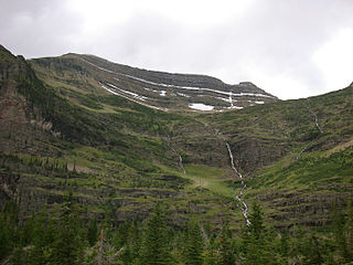
Lincoln Lake is located in Glacier National Park, in the U. S. state of Montana. Lincoln Lake is .25 miles (0.40 km) downstream from Lake Ellen Wilson but sits more than 1,300 feet (400 m) lower in elevation. A series of cascades including Beaver Chief Falls can be found between the two lakes.

Lake Ellen Wilson is located in Glacier National Park, in the U. S. state of Montana. Lake Ellen Wilson is .25 miles (0.40 km) upstream from Lincoln Lake but is more than 1,300 feet (400 m) higher in elevation. A series of cascades including Beaver Chief Falls can be found between the two lakes.
Lake Pinchot is a lake in Sweet Grass County, Montana, in the United States.


