
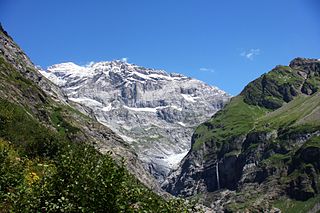
Piz Palü is a mountain in the Bernina Range of the Alps, located between Switzerland and Italy. It is a large glaciated massif composed of three main summits, on a ridge running from west to east. The main summit is 3,900 metres high and is located within the Swiss canton of Graubünden, although the border with the Italian region of Lombardy runs about 100 metres west of it at almost the same height. The western summit is named Piz Spinas and is the only one not covered by ice. The eastern summit is named Piz Palü Orientale. The name Palü derives from the Latin palus, meaning a swamp, and the mountain is said to be named after the Alpe Palü, a high alpine pasture some 4 km to its east.

The Aiguille d'Argentière is a mountain in the Mont Blanc massif on the border between France and Switzerland.

Les Droites is a mountain in the Mont Blanc massif in the French Alps and is the lowest of the 4000-metre peaks in the Alps. The mountain has two summits:
The Schärhorn is a mountain in the Glarus Alps near Klausen Pass. The highest summit is named Gross Schärhorn while a second summit is named Chli Schärhorn. The mountain overlooks the valley of Schächental to the north side, and the Hüfifirn to the southeast, which finally leads to the Maderanertal to the southwest. Both valleys are located in the canton of Uri.
The Pointe d'Orny is a mountain of the Mont Blanc massif, located west of Orsières in the canton of Valais. It lies north-east of the Plateau du Trient.

Le Portalet is a mountain of the Mont Blanc massif, located west of Praz de Fort in the canton of Valais. It lies on the range between the glaciers of Trient and Saleina. It has two important subsidiary summits: Grand Clocher du Portalet and Petit Clocher du Portalet. The latter forms a needle and is particularly hard to climb.

The Becs de Bosson are a multi-summited mountain of the Pennine Alps, located between St-Martin and Grimentz, in the canton of Valais.

The Oldenhorn is a mountain in the western Bernese Alps in Switzerland. The summit is the tripoint between the cantons of Vaud, Berne and Valais.

La Singla, also spelled La Sengla, is a 3,714 m mountain of the Pennine Alps, located on the border between Switzerland and Italy. It is the highest summit lying between the valleys of Bagnes (Valais) and Valpelline. On its northern side La Singla overlooks the Otemma Glacier.

Tête Blanche is a mountain of the Pennine Alps on the Swiss-Italian border. Its summit is the tripoint between the valleys of Hérens, Mattertal and Valpelline, thus forming the linguistic tri-point between French, German, and Italian-speaking areas.

The Aiguilles Dorées are a multi-summited mountain of the Mont Blanc massif, overlooking the Plateau du Trient in the canton of Valais. They lie east of the Petite Fourche, on the range between the glaciers of Trient and Saleina.
The Pointe des Plines is a minor peak on the east edge of the Mont Blanc massif, close to the Aiguille Dorees, and overlooking the Saleina Glacier in the canton of Valais.

La Maya is a mountain of the Pennine Alps, overlooking St-Martin in the canton of Valais. It lies between the Val d'Hérens and the Val de Réchy, west of the Becs de Bosson.
The Roc d'Orzival is a mountain of the Swiss Pennine Alps, overlooking Grimentz in the canton of Valais. It lies north of the Becs de Bosson, on the chain between the Val de Réchy and the Val d'Anniviers.

The Dents de Bouquetins or just the Bouquetins are a multi-summited mountain of the Alps between Switzerland and Italy. They form a ridge composed of several summits above 3,600 metres, of which the highest is 3,838 metres. The Bouquetins are the highest mountain on the main watershed of the Pennine Alps west of the Dent d'Hérens.
The Pigne de la Lé is a mountain of the Swiss Pennine Alps, located south of Zinal in the canton of Valais. It lies north of the Grand Cornier, on the range between the Moiry Glacier and the valley of Zinal.

The Bec du Corbeau is a mountain of the Chablais Alps, overlooking Morgins in the Swiss canton of Valais. It lies west of Pointe de Bellevue, on the watershed between the valleys of the Dranse d'Abondance and Illiez. The French border runs west of the mountain.

